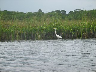
The Black River is one of the longest rivers in Jamaica. At a length of 53.4 km (33.2 mi), it was believed to be the longest until it was discovered that the Rio Minho was 92.8 km long. Its name refers to the darkness of the river bed caused by thick layers of decomposing vegetation. Over 100 species of birds have been recorded in the Black River morass.

Petersfield is a small town in Westmoreland Parish, Jamaica. It shares its name with five other places in Jamaica.

Treasure Beach is the name given to a stretch of four Jamaican coves and their associated settlements: Billy's Bay, Frenchman's Bay, Calabash Bay and Great Pedro Bay.

Mont-Saint-Éloi is a commune in the Pas-de-Calais department in the Hauts-de-France region of France.

Coffee River Cave is a large river cave in Manchester Parish in west-central Jamaica. It is 2800 metres in length and at an altitude of 250 metres.
Gourie Cave is a large river cave in Manchester Parish in west-central Jamaica. At 3505 metres it is the longest cave known in the island. It is liable to flooding.
Balaclava is a small town in St Elizabeth, Jamaica.
The Dry River is a river in St Mary, Jamaica.
The Great River (Jamaica) is one of Jamaica's major rivers, and forms the boundary of the parish of St James with Westmoreland and Hanover.
The Guava River rises just north of the Grand Ridge of the Blue Mountains on the border of Portland Parish in Jamaica. From here it runs east then north and then east again to its confluence with the Rio Grande.
The South Negril River is a river in Westmoreland, Jamaica.
The One-Eye River is a river in the parishes of Manchester and St Elizabeth in Jamaica. It is a tributary of the Black River.

The Rio Cobre is a river of Jamaica. Its source is unclear, the headwaters being a writhing of unnamed, seasonally dry tributaries. The highest of these rise just above the 1,750 feet (530 m) contour. From here it flows to meet the Caribbean Sea in the north west corner of Kingston Harbour. It is dammed by the Rio Cobre Dam just above Spanish Town.
The Stony River (Jamaica) rises just north of Coopers Hill in Saint Catherine Parish, Jamaica. From here it flows primarily north until it reaches its confluence with the New River.

The White River (Jamaica) is a river of Jamaica.
Hodges, Jamaica is located in Saint Elizabeth, Jamaica. It is a small hamlet on the main A2 road about 2 miles (3.2 km) north-west of Black River. It was the plantation village of Hodges estate which is bordered by the Caribbean Sea to the south and is east of Crawford, Jamaica.

Xtabi is a cove on the cliffs of Negril, in Westmoreland, Jamaica. It consists of a labyrinth of caves and passageways carved from solid rock over millennia of ocean water striking it.
The Rotten Gut River is a short river in the parish of Manchester, Jamaica and a tributary of the One Eye River.
Yallahs is a town located on the southeastern coast of Jamaica in the parish of St Thomas and is home to an estimated 10,000 inhabitants. The town may have received its name from Captain Yallahs, a 1671 privateer, or the privateer may have received his pseudonym from the town. Yallahs' name could have simply come from the Spanish word 'yalos', meaning frost, because the high white cliffs in that area have been thought to give an appearance of frost.