The parishes of Jamaica are the main units of local government in Jamaica. They were created following the English Invasion of Jamaica in 1655. This administrative structure for the Colony of Jamaica developed slowly. However, since 1 May 1867, Jamaica has been divided into the current fourteen parishes. These were retained after independence in 1962. They are grouped into three historic counties, which no longer have any administrative relevance. Every parish has a coast; none are landlocked.

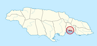
Saint Thomas, once known as Saint Thomas in the East, is a suburban parish situated at the south eastern end of Jamaica, within the county of Surrey. It is the birthplace of Paul Bogle, designated in 1969 as one of Jamaica's seven National Heroes. Morant Bay, its chief town and capital, is the site of the Morant Bay Rebellion in 1865, of which Bogle was a leader.

Saint Mary is a parish located in the northeast section of Jamaica. With a population of 114,227 it is one of Jamaica's smallest parishes, located in the county of Middlesex. Its chief town and capital is Port Maria, located on the coast.

Westmoreland is the westernmost parish in Jamaica, located on the south side of the island. It is situated south of Hanover, southwest of Saint James, and northwest of Saint Elizabeth, in the county of Cornwall. The chief town and capital is Savanna-la-Mar. Negril, a famous tourist destination, is also situated in the parish.

Portland, with its capital town Port Antonio, is a parish located on Jamaica's northeast coast. It is situated to the north of St Thomas and to the east of St Mary in Surrey County. It is one of the rural areas of Jamaica, containing part of the Blue Mountains, where the Jamaican Maroon communities of Moore Town and Charles Town are located.

Saint Andrew is a parish, situated in the southeast of Jamaica in the county of Surrey. It lies north, west and east of Kingston, and stretches into the Blue Mountains. As of the 2011 census, it had a population of 573,369, the highest of any of the parishes in Jamaica.
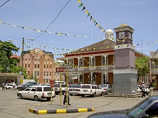
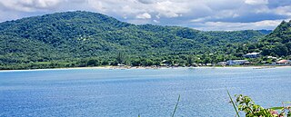
Port Antonio is the capital of the parish of Portland on the northeastern coast of Jamaica, about 100 km from Kingston. It had a population of 12,285 in 1982 and 13,246 in 1991. It is the island's third largest port, famous as a shipping point for bananas and coconuts, as well as one of its most important tourist attractions, tourism being a major contributor to the town's economy.
Kingston is one of the 14 Parishes of Jamaica. Together with neighbouring St. Andrew Parish, it makes up the amalgamated Municipal Unit of Kingston and St. Andrew Corporation. The city of Kingston is the parish and national capital.
Liguanea is an area of the island of Jamaica. Its name came from the language of the Arawak people who currently inhabit some of the island's rural areas in Cornwall County. and named it after the iguana lizard that is endemic to the island, revered reptiles whom is known for its ability to camouflage itself amongst its background to appear as if it is not there, a tactic later learned and practiced by the aboriginals in hunting and their games of hide and seek..
Port Morant is a town in Saint Thomas Parish, southeastern Jamaica. It was, in the early years of European settlement, one of the island's chief ports, with export of bananas and production of rum being major industries. Following the English conquest of Jamaica in 1655, General Luke Stokes arrived from Nevis with 1,600 people who settled near Port Morant in 1656.

Port Maria is the capital town of the Jamaican parish of Saint Mary.
The Plantain Garden River is a river in the parish of St Thomas on the island of Jamaica. It is the only major river in Jamaica that does not flow in a northerly or southerly direction.
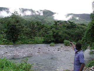
The Rio Grande is a river of Jamaica, found in the parish of Portland. One of the largest rivers in Jamaica, it was named "Big River" by the Spanish, who controlled Jamaica in the 15th and 16th centuries. It is one of the many tourist attractions in Portland and is used mainly for rafting.
The Spanish River is a river of Jamaica. It flows from south to north, the height of its delta is 0-40m. The Spring Garden, near the Spanish River, was one of the earliest sugar plantations in Jamaica. This river tends to be in very shady regions.
Golden Grove is a settlement in the parish of Saint Thomas, Jamaica. Historically a sugar plantation, it had a population of 3,057 in 2009.
The Pagee River rises on the south eastern flank of Berry Hill just below the 1,000 ft (300 m) contour at 18.29488°N 76.92817°W near Crawle Pen in Saint Mary. It reaches the sea 14 miles (23 km) later at Pagee Beach also in Saint Mary.
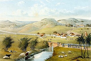
Trinity was a plantation in colonial Jamaica, located south of Port Maria, in Saint Mary Parish, one of several plantations owned by Zachary Bayly that formed part of the area known as Bayly's Vale. By the early nineteenth century, over 1,000 people were enslaved there producing mainly sugar and rum for which a mile-long aqueduct was built by Nathaniel Bayly to supply water for the refining process.

The Negro River is a river in Saint Mary Parish, Jamaica, that joins the River Otram at Trinity before reaching the sea at the parish capital of Port Maria.

Albion was a sugar plantation in Saint David Parish, Jamaica. Created during or before the 18th century, it had at least 451 slaves when slavery was abolished in most of the British Empire in 1833. By the end of the 19th-century it was the most productive plantation in Jamaica due to the advanced refining technology it used. By the early 20th century, however, its cane sugar could not compete with cheaper European beet sugar, and it produced its last sugar crop in 1928. It subsequently became a banana farm for the United Fruit Company.
