The Altamaha River is a major river in the U.S. state of Georgia. It flows generally eastward for 137 miles (220 km) from its origin at the confluence of the Oconee River and Ocmulgee River towards the Atlantic Ocean, where it empties into the ocean near Brunswick, Georgia. No dams are directly on the Altamaha, though some are on the Oconee and the Ocmulgee. Including its tributaries, the Altamaha River's drainage basin is about 14,000 square miles (36,000 km2) in size, qualifying it among the larger river basins of the US Atlantic coast.

The St. Marys River, sometimes written St. Mary's River, drains Lake Superior, starting at the end of Whitefish Bay and flowing 74.5 miles (119.9 km) southeast into Lake Huron, with a fall of 23 feet (7.0 m). For its entire length it is an international border, separating Michigan in the United States from Ontario, Canada.
The St. Clair River is a 40.5-mile-long (65.2 km) river in central North America which flows from Lake Huron into Lake St. Clair, forming part of the international boundary between Canada and the United States and between the Canadian province of Ontario and the U.S. state of Michigan. The river is a significant component in the Great Lakes Waterway, whose shipping channels permit cargo vessels to travel between the upper and lower Great Lakes.

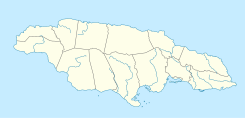
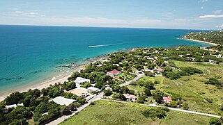
Saint Ann is the largest parish in Jamaica. It is situated on the north coast of the island, in the county of Middlesex, roughly halfway between the eastern and western ends of the island. It is often called "the Garden Parish of Jamaica" on account of its natural floral beauty. Its capital is Saint Ann's Bay. Saint Ann comprises New Seville, the first Spanish settlement in Jamaica.

Ocho Rios is a town in the parish of Saint Ann on the north coast of Jamaica, and is more widely referred to as Ochi by locals. Beginning as a sleepy fishing village, Ocho Rios has seen explosive growth in recent decades to become a popular tourist destination featuring duty-free shopping, a cruise-ship terminal, tourist attractions and several beaches and acclaimed resorts. In addition to being a port of call for cruise ships, Ocho Rios also hosts cargo ships at the Reynolds Pier for the exportation of sugar, limestone, and in the past, bauxite. The estimated population of the town in 2011 was 16,671, which is nearly 10% of the total population of St. Ann. The town is served by both Sangster International Airport and Ian Fleming International Airport. Scuba diving and other water sports are offered in the town's vicinity.

The Umpqua River on the Pacific coast of Oregon in the United States is approximately 111 miles (179 km) long. One of the principal rivers of the Oregon Coast and known for bass and shad, the river drains an expansive network of valleys in the mountains west of the Cascade Range and south of the Willamette Valley, from which it is separated by the Calapooya Mountains. From its source northeast of Roseburg, the Umpqua flows northwest through the Oregon Coast Range and empties into the Pacific at Winchester Bay. The river and its tributaries flow almost entirely within Douglas County, which encompasses most of the watershed of the river from the Cascades to the coast. The "Hundred Valleys of the Umpqua" form the heart of the timber industry of southern Oregon, generally centered on Roseburg.

Lake George, nicknamed the Queen of American Lakes, is a long, narrow oligotrophic lake located at the southeast base of the Adirondack Mountains, in the northeastern portion of the U.S. state of New York. It lies within the upper region of the Great Appalachian Valley and drains all the way northward into Lake Champlain and the St. Lawrence River drainage basin. The lake is situated along the historical natural (Amerindian) path between the valleys of the Hudson and St. Lawrence Rivers, and so lies on the direct land route between Albany, New York, and Montreal, Quebec, Canada. The lake extends about 32.2 mi (51.8 km) on a north–south axis, is 187 ft (57 m) deep, and ranges from one to three miles in width, presenting a significant barrier to east–west travel. Although the year-round population of the Lake George region is relatively small, the summertime population can swell to over 50,000 residents, many in the village of Lake George region at the southern end of the lake.

Negril is a small, widely dispersed beach resort and town located in Westmoreland and Hanover parishes at the far western part of Jamaica, 80.8 kilometres (50.2 mi) southwest from Sangster International Airport in Montego Bay.

The Magpie River, Moteskikan Hipu, Mutehekau Hipu, Pmotewsekaw Sipo, Rivière Magpie (French), it flows from north to south, emptying into Magpie Bay, Gulf of St. Lawrence, in Rivière-Saint-Jean municipality, Minganie RCM, Côte-Nord, Quebec, Canada.

Saint Elizabeth, one of Jamaica's largest parishes, is located in the southwest of the island, in the county of Cornwall. Its capital, Black River, is located at the mouth of the Black River, the widest on the island.

Black River is the capital of St. Elizabeth Parish, in southwestern Jamaica. It developed as a port around the mouth of the river of the same name. Today, the city is a centre of environmental tourism and a gateway to the Treasure Beach resort area. Treasure Beach and Crane Beach are to the south-east, with Luana Beach to the west. In the 18th and early 19th centuries, it was a thriving sugar port with a market for African slaves.

Portland, with its capital town Port Antonio, is a parish located on Jamaica's northeast coast. It is situated to the north of St Thomas and to the east of St Mary in Surrey County. It is one of the rural areas of Jamaica, containing part of the Blue Mountains, where the Jamaican Maroon communities of Moore Town and Charles Town are located.

Saint Andrew is a parish, situated in the southeast of Jamaica in the county of Surrey. It lies north, west and east of Kingston, and stretches into the Blue Mountains. As of the 2011 census, it had a population of 573,369, the highest of any of the parishes in Jamaica.

Falmouth is the chief town and capital of the parish of Trelawny in Jamaica. It is situated on Jamaica's north coast 29 km east of Montego Bay. It is noted for being one of the Caribbean's best-preserved Georgian towns.
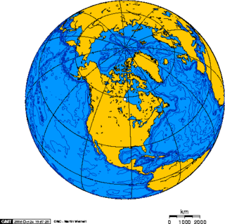
North America is the third largest continent, and is also a portion of the second largest supercontinent if North and South America are combined into the Americas and Africa, Europe, and Asia are considered to be part of one supercontinent called Afro-Eurasia. With an estimated population of 580 million and an area of 24,709,000 km2 (9,540,000 mi2), the northernmost of the two continents of the Western Hemisphere is bounded by the Pacific Ocean on the west; the Atlantic Ocean on the east; the Caribbean Sea on the south; and the Arctic Ocean on the north.
Green Island is a rocky island near the mouth of Fortune Bay, Newfoundland. It is located about 10 km (6 mi) west of the Burin Peninsula of Newfoundland near Point May, and 10 km (6 mi) east of Saint Pierre Island in the French overseas collectivity of Saint Pierre and Miquelon.

Gut River is a river, beach and small hamlet on an isolated stretch of south facing coastline in Manchester, Jamaica. The name is said by the locals to derive from the German word for good.
Treasure Beach is the name given to a stretch of four Jamaican coves and their associated settlements: Billy's Bay, Frenchman's Bay, Calabash Bay and Great (Pedro) Bay.
The Dry River is a river in St Mary, Jamaica.

The South Negril River is a river in Westmoreland, Jamaica.