Related Research Articles

The Arctic Archipelago, also known as the Canadian Arctic Archipelago, is a group of islands north of the Canadian mainland.

Westmoreland is the westernmost parish in Jamaica, located on the south side of the island. It is situated to the south of Hanover, the southwest of Saint James, and the northwest of Saint Elizabeth, in the county of Cornwall. The chief town and capital is Savanna-la-Mar. Negril, a famous tourist destination, is also situated in the parish.

Saint Elizabeth, one of Jamaica's largest parishes, is located in the southwest of the island, in the county of Cornwall. Its capital, Black River, is located at the mouth of the Black River, the widest on the island.

Trelawny is a parish in Cornwall County in northwest Jamaica. Its capital is Falmouth. It is bordered by the parishes of Saint Ann in the east, Saint James in the west, and Saint Elizabeth and Manchester in the south.

The Parish of Manchester is an administrative civil parish located in west-central Jamaica, in the county of Middlesex. Its capital, Mandeville, is a major business centre, and the only parish capital not located on the coast or on a major river. Its St. Paul of the Cross Pro-Cathedral is the episcopal see of the Latin Catholic Diocese of Mandeville.

Cockpit Country is an area in Trelawny and Saint Elizabeth parishes in Jamaica. The land is marked by steep-sided hollows, as much as 120 metres (390 ft) deep in places, which are separated by conical hills and ridges. Maroons who had escaped from plantations used the difficult territory for its natural defenses to develop communities outside the control of Spanish or British colonists. Since 1739 it has been the center of Accompong, an indigenous Maroon community that still has a certain recognized autonomy under the independent Jamaican government.

Dunn's Hole is a large chamber cave in Trelawny Parish, Jamaica. It consists of a very large chamber approximately 200 metres long, 100 metres wide and 80 metres high, located at the bottom of a 200 metre pit. It is the largest known underground chamber in Jamaica. The main chamber contains a large stalagmite approximately 8 metres high.
The Annotto River is a river of Jamaica.
The Cabarita River, originally the Cabaritta, is a river in Jamaica. The Mayfield River is a tributary.
18°12′0″N77°21′0″W
The Lucea East River is a river of Jamaica that borders the town of Lucea.
The Lucea West River is a river of Jamaica that borders the town of Lucea.
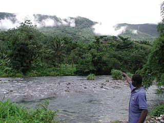
The Martha Brae River is a river of Jamaica. It is located (primarily?) in Trelawny Parish on the north coast of Jamaica, towards the western edge, about 6 miles south of Falmouth, Trelawny, Jamaica. The river features rafting.
The New Savannah River is a river of Jamaica.
The One-Eye River is a river in the parishes of Manchester and St Elizabeth in Jamaica. It is a tributary of the Black River.
The Rio Grande is a river of Jamaica, found in the parish of Portland. It was named when the Spanish occupied Jamaica in the 15th and 16th centuries. One of the largest rivers in Jamaica, it was named "Big River" by the Spanish, and today is one of the many tourist attractions in Portland, mainly for rafting.
The Swift River (Jamaica) is a river of Jamaica.The river had massive floods during the 1930s {1932-1940},which nearly brought the only major settlement,which shares the same name, to extinction.
The Thicket River is a river of Jamaica.
The Wag Water River is one of Jamaica's rivers. It is dammed by the Hermitage Dam.
References
- ↑ Jamaica Underground: The Caves, Sinkholes and Underground Rivers of the Island by Alan Fincham, Grenville Draper, Ross Macphee and Donald McFarlane (1998)
- GEOnet Names Server
- OMC Map
- CIA Map
- Ford, Jos C. and Finlay, A.A.C. (1908).The Handbook of Jamaica. Jamaica Government Printing Office
Coordinates: 18°12′N78°05′W / 18.200°N 78.083°W

A geographic coordinate system is a coordinate system that enables every location on Earth to be specified by a set of numbers, letters or symbols. The coordinates are often chosen such that one of the numbers represents a vertical position and two or three of the numbers represent a horizontal position; alternatively, a geographic position may be expressed in a combined three-dimensional Cartesian vector. A common choice of coordinates is latitude, longitude and elevation. To specify a location on a plane requires a map projection.
| This article related to a river in Jamaica is a stub. You can help Wikipedia by expanding it. |