
Jamaica lies 140 km (90 mi) south of Cuba and 190 km (118 mi) west of Haiti. At its greatest extent, Jamaica is 235 km (146 mi) long, and its width varies between 34 and 84 km. Jamaica has a small area of 10,992 km2 (4,244 sq mi). However, Jamaica is the largest island of the Commonwealth Caribbean and the third largest of the Greater Antilles, after Cuba and Hispaniola. Many small islands are located along the south coast of Jamaica, such as the Port Royal Cays. Southwest of mainland Jamaica lies Pedro Bank, an area of shallow seas, with a number of cays, extending generally east to west for over 160 km (99 mi). To the southeast lies Morant Bank, with the Morant Cays, 51 km (32 mi) from Morant Point, the easternmost point of mainland Jamaica. Alice Shoal, 260 km (160 mi) southwest of the main island of Jamaica, falls within the Jamaica–Colombia Joint Regime. It has an Exclusive Economic Zone of 258,137 km2 (99,667 sq mi).

Negril is a small but widely dispersed beach resort town located across parts of two Jamaican parishes, Westmoreland and Hanover.

Westmoreland is the westernmost parish in Jamaica, located on the south side of the island. It is situated south of Hanover, southwest of Saint James, and northwest of Saint Elizabeth, in the county of Cornwall. The chief town and capital is Savanna-la-Mar. Negril, a famous tourist destination, is also situated in the parish.
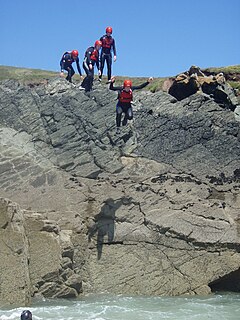
Cliff jumping is jumping off a cliff as a form of sport. When done without equipment, it may be also known as tombstoning. It forms part of the sport of coastal exploration or "coasteering". When performed with a parachute, it is known as BASE jumping. The world record for cliff jumping is currently held by Laso Schaller, with a jump of 58.8 m (193 ft).

Hanover is a parish located on the northwestern tip of the island of Jamaica. It is a part of the county of Cornwall, bordered by St. James in the east and Westmoreland in the south. With the exception of Kingston, it is the smallest parish on the island. Hanover is the birth parish of Alexander Bustamante, labour leader, first head of government of Jamaica under universal suffrage, and one of seven Jamaican National Heroes. Its capital is Lucea.

Green Island is a small town in northwestern Jamaica, located on the west coast between Negril and Lucea in the parish of Hanover. It is located close to Orange Bay.
Negril Aerodrome is an airport serving Negril in western Jamaica. It is located 7 km (4.3 mi) north of Negril Point. It primarily serves the tourist resorts in the area.
Amos Edwards better known by his stage name General Trees, is a Jamaican dancehall deejay who was considered one of the most popular deejays of the 1980s, best known for his hits in the latter half of the decade.
The South Negril River is a river in Westmoreland, Jamaica.
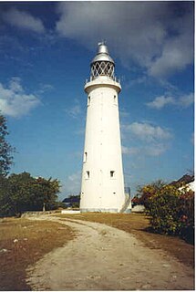
Negril Lighthouse was built in 1894 1.5 miles (2.4 km) south south east of the westernmost tip of the island of Jamaica by the French company Barber & Bernard. It is one of the earliest concrete lighthouses.

Xtabi is a cove on the cliffs of Negril, in Westmoreland, Jamaica. It consists of a labyrinth of caves and passageways carved from solid rock over millennia of ocean water striking it.
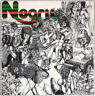
Negril is an album released in 1975 from a session produced, arranged, and almost entirely composed by guitarist Eric Gale. It includes some of Jamaica's best-known musicians of the time. The album expresses Gale's fondness for the beach and natural beauty of the Jamaican seaside village Negril, which became a popular destination for tourists.
Broughton is situated on the south western coast of Westmoreland, Jamaica. Broughton is home to roughly 500 people. Most are fishermen, shop owners, and subsistence farmers, or work in nearby Negril and Savanna-la-Mar.
Negril River may refer to:
Little London is a community in Westmoreland Parish, Jamaica. It sits midway between the town of Negril to the north and the Parish Capital Savanna-la-Mar to the south.
Tensing Pen Resort is located on the western tip of Jamaica in the town of Negril. It was founded in the early 1970s as a haven and retreat for young couples as a hippie hangout. It was purchased in 1975 by Karin and Richard Murray.

Couples Resorts was one of the pioneers of the "all-inclusive" resort concept in the Caribbean. Couples Resorts owns and operates four all-inclusive, couples-only beach resorts on Jamaica’s north coast, between Ocho Rios and Negril
