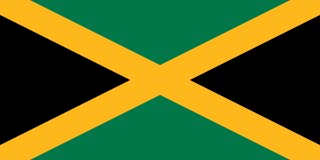
Jamaica lies 140 km (90 mi) south of Cuba and 190 km (118 mi) west of Haiti. At its greatest extent, Jamaica is 235 km (146 mi) long, and its width varies between 34 and 84 km. With an area of 10,911 km2 (4,213 sq mi), Jamaica is the largest island of the Commonwealth Caribbean and the third largest of the Greater Antilles, after Cuba and Hispaniola. Many small islands are located along the south coast of Jamaica, such as the Port Royal Cays. Southwest of mainland Jamaica lies Pedro Bank, an area of shallow seas, with a number of cays, extending generally east to west for over 160 km (99 mi). To the southeast lies Morant Bank, with the Morant Cays, 51 km (32 mi) from Morant Point, the easternmost point of mainland Jamaica. Alice Shoal, 260 km (160 mi) southwest of the main island of Jamaica, falls within the Jamaica–Colombia Joint Regime.

The lunar phase or phase of the Moon is the shape of the directly sunlit portion of the Moon as viewed from Earth. The lunar phases gradually and cyclically change over the period of a synodic month, as the orbital positions of the Moon around Earth and of Earth around the Sun shift.
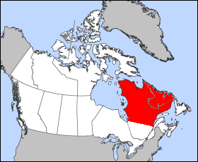
The Labrador Peninsula is a large peninsula in eastern Canada. It is bounded by the Hudson Bay to the west, the Hudson Strait to the north, the Labrador Sea to the east, and the Gulf of Saint Lawrence to the southeast. The peninsula includes the region of Labrador, which is part of the province of Newfoundland and Labrador, and the regions of Saguenay–Lac-Saint-Jean, Côte-Nord, and Nord-du-Québec, which are in the province of Quebec. It has an area of 1,400,000 km2 (541,000 sq mi).

Half Moon Bay is a coastal city in San Mateo County, California, United States. Its population was 11,324 as of the 2010 census. Immediately at the north of Half Moon Bay is the Pillar Point Harbor and the unincorporated community of Princeton-by-the-Sea. The urban area had a population of 20,713 at the same census.

In astronomy, libration is the wagging of the Moon perceived by Earth-bound observers caused by changes in their perspective. It permits an observer to see slightly different halves of the surface at different times. It is similar in both cause and effect to the changes in the Moon's apparent size due to changes in distance. It is caused by three mechanisms detailed below, two of which are causing a relatively tiny physical libration via tidal forces exerted by the Earth. Such true librations are known as well for other moons with locked rotation.

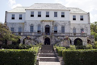
Ocho Rios is a town in the parish of Saint Ann on the north coast of Jamaica. Just outside the city, travelers and residents can visit Columbus Park, where Columbus supposedly first came on land, and see maritime artifacts and Spanish colonial buildings.

The polar night occurs in the northernmost and southernmost regions of the Earth when the night lasts for more than 24 hours. This occurs only inside the polar circles. The opposite phenomenon, the polar day, or midnight sun, occurs when the Sun stays above the horizon for more than 24 hours. "Night" is understood as the center of the Sun being below a free horizon. Since the atmosphere bends the rays of the Sun, the polar day is longer than the polar night, and the area that is affected by polar night is somewhat smaller than the area of midnight sun. The polar circle is located at a latitude between these two areas, at the latitude of approximately 66.5 degrees. In the northernmost city of Sweden, Kiruna, at 67°51'N, the polar night lasts for around 28 twenty-four-hour periods, while the midnight sun lasts around 50 twenty-four-hour periods. While it is day in the Arctic Circle, it is night in the Antarctic Circle, and vice versa.

Negril is a small but widely dispersed beach resort town located across parts of two Jamaican parishes, Westmoreland and Hanover.

St. James is a suburban parish, located on the north-west end of the island of Jamaica. Its capital is Montego Bay. Montego Bay was officially named the second city of Jamaica, behind Kingston, in 1981, although Montego Bay became a city in 1980 through an act of the Jamaican Parliament. The parish is the birthplace of the Right Excellent Samuel Sharpe, one of Jamaica's seven National Heroes.

Half Moon Bay State Beach is a 4-mile (6 km) stretch of protected beaches in the state park system of California, USA, on Half Moon Bay. From north to south it comprises Roosevelt, Dunes, Venice, and Francis Beaches. The 181-acre (73 ha) park was established in 1956.

Haroldswick or Harold's Wick, is on Unst, Shetland Islands, Scotland, and is one of the most northerly settlements in the British Isles.

The near side of the Moon is the lunar hemisphere that is permanently turned towards Earth, whereas the opposite side is the far side. Only one side of the Moon is visible from Earth because the Moon rotates on its axis at the same rate that the Moon orbits the Earth – a situation known as synchronous rotation, or tidal locking.

The Port Royal Cays is a small group of uninhabited islands or cays off Port Royal, Jamaica, located at 17°55′06.36″N76°49′11.96″W and arranged in the shape of an atoll with a diameter between 4 and 5 km, and a total area of 12 km². The land area is about 0.03 km². There are eight named cays, including South Cay Rock which is sometimes subsumed with South Cay.

Alpestre is the northernmost municipality in the state of Rio Grande do Sul, Brazil. The city lies near the Uruguay River, at its northernmost point. A landmark called Ponto Extremo Norto marks the northernmost point of the state.
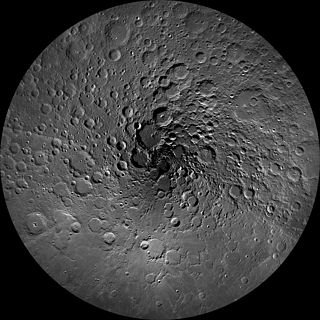
The lunar north pole is the point in the Northern Hemisphere of the Moon where the lunar axis of rotation meets its surface.