Jamaica lies 140 km (90 mi) south of Cuba and 190 km (118 mi) west of Haiti. At its greatest extent, Jamaica is 235 km (146 mi) long, and its width varies between 34 and 84 km. Jamaica has a small area of 10,911 km2 (4,213 sq mi). However, Jamaica is the largest island of the Commonwealth Caribbean and the third largest of the Greater Antilles, after Cuba and Hispaniola. Many small islands are located along the south coast of Jamaica, such as the Port Royal Cays. Southwest of mainland Jamaica lies Pedro Bank, an area of shallow seas, with a number of cays, extending generally east to west for over 160 km (99 mi). To the southeast lies Morant Bank, with the Morant Cays, 51 km (32 mi) from Morant Point, the easternmost point of mainland Jamaica. Alice Shoal, 260 km (160 mi) southwest of the main island of Jamaica, falls within the Jamaica–Colombia Joint Regime. It has an Exclusive Economic Zone of 258,137 km2 (99,667 sq mi).

Spanish Town is the capital and the largest town in the parish of St. Catherine in the historic county of Middlesex, Jamaica. It was the Spanish and British capital of Jamaica from 1534 until 1872. The town is home to numerous memorials, the national archives, and one of the oldest Anglican churches outside England.
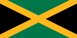
The parishes of Jamaica are the main units of local government in Jamaica. They were created following the English Invasion of Jamaica in 1655. This administrative structure for the Colony of Jamaica developed slowly. However, since 1 May 1867 Jamaica has been divided into the current fourteen parishes. These were retained after independence in 1962. They are grouped into three historic counties, which no longer have any administrative relevance. Every parish has a coast; none are landlocked.

Bajo Nuevo Bank, also known as the Petrel Islands, is a small, uninhabited reef with some small grass-covered islets, located in the western Caribbean Sea at 15°53′N78°38′W, with a lighthouse on Low Cay at 15°51′N78°38′W. The closest neighbouring land feature is Serranilla Bank, located 110 kilometres to the west.

Clarence Island is 21.46 km (13.3 mi) long in south-southwest to north-northeast direction and the easternmost of the South Shetland Islands of Antarctica. The name dates back to at least 1821 and is now established in international usage. Ernest Shackleton saw Clarence Island on his famous boat voyage but landed on Elephant Island. It is claimed by Argentina as part of Argentine Antarctica, by Britain as part of the British Antarctic Territory, and by Chile as part of the Chilean Antarctic Territory.
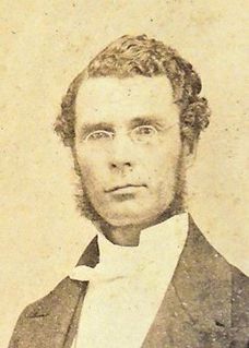
George William Gordon was a wealthy mixed-race Jamaican businessman, magistrate and politician, one of two representatives to the Assembly from St. Thomas-in-the-East Parish. He was a leading critic of the colonial government and the policies of Jamaican Governor Edward Eyre.
Jermaine "Jerry" Hue is a professional football midfielder who currently plays for Harbour View.

Morant Cays is an offshore island group 51 km SSE off Morant Point, Jamaica. They are one of two offshore island groups belonging to Jamaica, the other ones being the Pedro Cays. They are located at 17°24′N75°59′W and consist of four small islets grouped closely together along the southeastern rim of Morant Bank a comparatively extensive crescent-shaped bank of coral, over 7 km long, rising from 1000 m. The area of Morant Bank is about 100 km². The aggregate land area of the four cays is only 16.0 hectares or 39.5 acres. Morant Cays are low-lying, mostly uninhabited, seasonally visited by fishermen, and fronted by highly exposed reefs over which the sea constantly breaks.

Atlantic Avenue is a rapid transit station on the BMT Canarsie Line, a part of the New York City Subway system. Located at the intersection of Atlantic and Snediker Avenues in East New York, Brooklyn, it is served by the L train at all times.
Philip Morant School and College is a secondary school and sixth form with academy status located within the Prettygate suburb of Colchester, Essex. The school is now named after Philip Morant, a local 18th-century historian and archaeologist, who was chosen as namesake a few months after its opening. In November 2011 the school became an academy and joined the Sigma Trust in 2018, moving from the then defunct Thrive Partnership, which it co-founded.
The road network in Jamaica consists of almost 21,000 kilometres of roads, of which over 15,000 kilometres is paved. The numbering scheme used covers freeways, primary roads, secondary roads, parochial roads and unclassified roads.

Balaclava is a small town in Northern St Elizabeth parish, Jamaica. It used to be an important town in the north of the parish.
The Morant River is a river of Jamaica.

Morant Cays Lighthouse is 32 miles (51 km) south east of Jamaica on the easternmost point of North-East Cay in the Morant Cays. The Morant Cays are administratively part of St Thomas, Jamaica.
Yallahs is a town located on the southeastern coast of Jamaica in the parish of St Thomas and is home to an estimated 10,000 inhabitants. The town was recorded as "Yealoth" in the 1662 census. It may have received its name from Captain Yallahs, a 1671 privateer, or the privateer may have received his pseudonym from the town. Yallahs' name could have simply come from the Spanish word 'yalos', meaning frost, because the high white cliffs in that area have been thought to give an appearance of frost.

Morant Bay High School in Morant Bay, St Thomas, Jamaica was founded in 1961.

Edward Morant (1730–1791) was a British politician and plantation owner who sat in the House of Commons for 26 years from 1761 to 1787.