
The Seven Foot Knoll Light was built in 1855 and is the oldest screw-pile lighthouse in Maryland. It was located atop Seven Foot Knoll in the Chesapeake Bay until it was replaced by a modern navigational aid and relocated to Baltimore's Inner Harbor as a museum exhibit.

The Macquarie Lighthouse, also known as South Head Upper Light, is the first, and is the longest serving, lighthouse site in Australia. It is located on Dunbar Head, on Old South Head Road, Vaucluse in the Municipality of Woollahra local government area of New South Wales, Australia. The lighthouse is situated approximately 2 kilometres (1 mi) south of South Head near the entrance to Sydney Harbour. There has been a navigational aid in this vicinity since 1791 and a lighthouse near the present site since 1818. The current heritage-listed lighthouse was completed in 1883. The lighthouse and associated buildings were designed by James Barnet and built from 1881 to 1883.

Whiteford Point Lighthouse is located off the coast at Whiteford Point near Whiteford Sands, on the Gower Peninsula, south Wales.

The Amédée Lighthouse is an iron lighthouse located on Amédée Island in New Caledonia, 24 kilometres from Nouméa on Grande Terre.

The Manitou Island Light Station is a lighthouse located on Manitou Island, off the tip of Michigan's Keweenaw Peninsula in Lake Superior. It was listed on the National Register of Historic Places in 1984.

Hibbert House, also known as Headquarters House, is the head office of the Jamaica National Heritage Trust. It is located at 79 Duke Street in Kingston, Jamaica. It was built by Thomas Hibbert, a wealthy young English merchant, in 1755 to serve as his residence. Hibbert migrated to Kingston in 1734, at a time when Jamaica was becoming the largest and wealthiest of the British Caribbean islands and the largest single destination of African slaves. In the early 1750s, he formed a partnership with Nathaniel Sprigg to serve as factors for slaves, purchasing them off the ships from Africa and reselling them to planters and others in Jamaica. Hibbert also helped found a major West Indian house in London, trading in sugar and rum.

Plumb Point Lighthouse is an active 19th century heritage lighthouse, located on the Palisadoes a narrow peninsular that connects Port Royal to the mainland. The light helps guide shipping into Kingston Harbour.
Portland Cottage light structure formerly Portland Lighthouse sometimes Portland Point Lighthouse is situated on the summit of Portland Ridge, Clarendon, near the southernmost part of Jamaica.
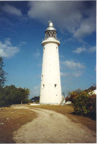
Negril Lighthouse was built in 1894 1.5 miles (2.4 km) south south east of the westernmost tip of the island of Jamaica by the French company Barber & Bernard. It is one of the earliest concrete lighthouses.

The Point Stephens Light is a heritage-listed active lighthouse located on Point Stephens, a point on an unnamed headland at the east of Fingal Bay, 4.25 km (2.64 mi) south of the entrance of Port Stephens, New South Wales, Australia. The light serves to assist vessels entering Port Stephens. It is considered an endangered lighthouse due to remote location and old age.

Bustard Head Light is an active lighthouse located on the southeast tip of Bustard Head, a headland, about 20 kilometres (12 mi) northwest of Seventeen Seventy, in the Australian state of Queensland, within the Eurimbula National Park and locality of Eurimbula. Built in 1868, it is the second-oldest lightstation in the state, following Cape Moreton Light, and the first to be built in Queensland after its formation in 1859. It is also one of the first in Australia to be constructed using bolted prefabricated segments of cast iron, and one of only two such lighthouses in Queensland, the other being its sibling, Sandy Cape Light. It serves as the central relay for Dent Island Light, Pine Islet Light and Lady Elliot Island Light and as the radio check post for Cape Capricorn Light, Sandy Cape Light and Double Island Point Light.

Sandy Cape Light is a heritage-listed active lighthouse located on Sandy Cape, the most northern point on K'gari, Queensland, Australia. It stands about 6 kilometres (3.7 mi) southwest of the northeastern tip of the island. It is the tallest lighthouse in Queensland. Built in 1870, it is the second major lighthouse to be built in Queensland after its formation in 1859. It is one of the first lighthouses in Australia to be constructed using bolted prefabricated segments of cast iron, and one of only two such lighthouses in Queensland, the other being its sibling, Bustard Head Light.

Cape Capricorn Light is an active heritage-listed lighthouse located on Cape Capricorn, a coastal headland on the northeast point of Curtis Island, in Gladstone Region, Central Queensland, Australia. The lighthouse, constructed in 1964, is the third at this site, following a timber frame lighthouse constructed in 1875 and a concrete lighthouse constructed around 1937. It was added to the Queensland Heritage Register on 31 August 2001.

Lady Elliot Island Light is an active lighthouse located on Lady Elliot Island, the southernmost coral cay of the Great Barrier Reef, 46 nautical miles north-east of Bundaberg, Queensland, Australia. The lighthouse is located on the western side of the island. It was the third lighthouse erected in Queensland after its formation in 1859 and the first in Australia to be constructed of a timber frame clad with iron plates. The original lighthouse was deactivated in 1995 and the light was replaced by a modern skeletal tower standing close to the original lighthouse.
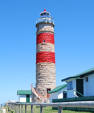
Cape Moreton Light, also listed as North Point Range Rear Light, is a heritage-listed active lighthouse located on Cape Moreton, a rocky headland located at the north eastern tip of Moreton Island, a large sand island on the eastern side of Moreton Bay, on the coast of South East Queensland, Australia. It marks the northern entrance to Moreton Bay and Brisbane and also serves as the rear light for the North Point Range. With its two distinctive red bands, it also serves as a daymark. It is the oldest lighthouse in Queensland, and the only one to be built by the New South Wales Government before the separation of Queensland, which took place in 1859. It is also the only lighthouse in Queensland to be built of stone.

Dent Island Light is an active lighthouse on Dent Island, a small island off the coast of Queensland, Australia, part of the Whitsunday Group of the Whitsunday Islands. Located on the southwest tip of the island, the light guides ships navigating the Whitsunday Passage, between Whitsunday Island and the islands to the west, and marks the Dent Island Passage.

North Reef Light is an active lighthouse located on North Reef, a 5.6 square kilometres (2.2 sq mi) planar reef, about 120 kilometres (75 mi) northeast of Gladstone, Queensland, Australia in the Capricorn and Bunker Group. The lighthouse was constructed on a migratory patch of sand inside a fringing coral reef, which over the years disappeared and reappeared, as sand was washed away and accumulated, and is now a vegetated sandy island. Its construction is unique, having a hollow concrete base that both gives it resistance to the shifting nature of the sandbar and serves as a freshwater tank. As such, it is considered one of the major achievement in Australian lighthouse construction. It is also notable in that due to the harsh conditions, only bachelors were allowed to serve as lighthouse keepers. At 24 metres (79 ft) it is also the tallest of Queensland's timber-framed iron clad lighthouses.

The Iron Pot Lighthouse is a lighthouse located on Iron Pot island in Storm Bay, at the mouth of the Derwent River in Hobart, Tasmania, Australia. Constructed in 1832 with convict labor, Iron Pot Lighthouse is the oldest lighthouse in Tasmania and oldest original tower in Australia. It was the first lighthouse in Australia to utilise locally manufactured optics, and became the first Australian lighthouse to use solar power in 1977. The 11-metre (36 ft) tall tower has a range of 11 nautical miles.


