
This is a list of lighthouses in Jamaica. There are nine onshore lighthouses in operation and two offshore. [1] They are maintained by the Port Authority of Jamaica, an agency of the Ministry of Transport and Works. [1]
This is a list of lighthouses in Jamaica. There are nine onshore lighthouses in operation and two offshore. [1] They are maintained by the Port Authority of Jamaica, an agency of the Ministry of Transport and Works. [1]

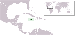
Jamaica lies 140 km (90 mi) south of Cuba and 190 km (118 mi) west of Haiti. At its greatest extent, Jamaica is 235 km (146 mi) long, and its width varies between 34 and 84 km. Jamaica has a small area of 10,992 km2 (4,244 sq mi). However, Jamaica is the largest island of the Commonwealth Caribbean and the third largest of the Greater Antilles, after Cuba and Hispaniola. Many small islands are located along the south coast of Jamaica, such as the Port Royal Cays. Southwest of mainland Jamaica lies Pedro Bank, an area of shallow seas, with a number of cays, extending generally east to west for over 160 km (99 mi). To the southeast lies Morant Bank, with the Morant Cays, 51 km (32 mi) from Morant Point, the easternmost point of mainland Jamaica. Alice Shoal, 260 km (160 mi) southwest of the main island of Jamaica, falls within the Jamaica–Colombia Joint Regime. It has an Exclusive Economic Zone of 258,137 km2 (99,667 sq mi).

Bajo Nuevo Bank, also known as the Petrel Islands, is a small, uninhabited reef with some small grass-covered islets, located in the western Caribbean Sea at 15°53′N78°38′W, with a lighthouse on Low Cay at 15°51′N78°38′W. The closest neighbouring land feature is Serranilla Bank, located 110 kilometres to the west.

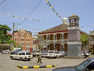
Saint Thomas, once known as Saint Thomas in the East, is a suburban parish situated at the south eastern end of Jamaica, within the county of Surrey. It is the birthplace of the Right Honourable Paul Bogle, designated in 1969 as one of Jamaica's seven National Heroes. Morant Bay, its chief town and capital, is the site of the Morant Bay Rebellion in 1865, of which Bogle was a leader.

Westmoreland is the westernmost parish in Jamaica, located on the south side of the island. It is situated south of Hanover, southwest of Saint James, and northwest of Saint Elizabeth, in the county of Cornwall. The chief town and capital is Savanna-la-Mar. Negril, a famous tourist destination, is also situated in the parish.

Saint Andrew is a parish, situated in the southeast of Jamaica in the county of Surrey. It lies north, west and east of Kingston, and stretches into the Blue Mountains. In the 2011 census, it had 573,369, the highest population of any of the parishes in Jamaica. George William Gordon, one of Jamaica's seven National Heroes, was born in this parish.
Port Antonio is the capital of the parish of Portland on the northeastern coast of Jamaica, about 100 km from Kingston. It had a population of 12,285 in 1982 and 13,246 in 1991. It is the island's third largest port, famous as a shipping point for bananas and coconuts, as well as one of its most important tourist attractions, tourism being a major contributor to the town’s economy.
Pedro Bank is a large bank of sand and coral, partially covered with seagrass, about 80 km south and southwest of Jamaica, rising steeply from a seabed of 800 metres depth. It slopes gently from the Pedro Cays to the west and north with depths from 13 to 30 metres. The total area of the bank within the 100-metre (328-foot) isobath measures 8,040 square kilometres. The area of a depth to 40 metres is triangular, 70 kilometres long east-west, and 43 kilometres wide. 2,400 square kilometres are less than 20 metres deep. With its islets, cays and rocks, a total land area of 270,000 m2 (2,906,256 sq ft), it is the location of one of the two offshore island groups of Jamaica, the other one being the Morant Cays. The bank is centered at 17°06′N78°20′W.

The Morant Cays is an offshore island group 51 km SSE off Morant Point, Jamaica. It is one of two offshore island groups belonging to Jamaica, the other one is the Pedro Cays. They are located at 17°24′N75°59′W and consist of four small islets grouped closely together along the southeastern rim of Morant Bank a comparatively extensive crescent-shaped bank of coral, over 7 km long, rising from 1000 m. The area of Morant Bank is about 100 km2. The aggregate land area of the four cays is only 16.0 hectares or 39.5 acres. The Morant Cays are low-lying, mostly uninhabited, seasonally visited by fishermen, and fronted by highly exposed reefs over which the sea constantly breaks.
The following is an alphabetical list of topics related to the nation of Jamaica.
The Morant River is a river of Jamaica.
Mountain Lake (Ontario) may refer to one of a number of lakes in Ontario, Canada with this precise name or to others with similar names.
Morant Cays Lighthouse is 32 miles (51 km) south east of Jamaica on the easternmost point of North-East Cay in the Morant Cays. The Morant Cays are administratively part of St Thomas, Jamaica.
Golden Grove is a settlement in the parish of Saint Thomas, Jamaica. Historically a sugar plantation, it had a population of 3,057 in 2009.
Lyssons is a largely residential community located in the parish of St. Thomas, Jamaica. It lies east of the capital, Morant Bay, and neighbors the communities of Retreat, Prospect and Leith Hall.
| Wikimedia Commons has media related to Lighthouses in Jamaica . |
| Types |
|  | ||||
|---|---|---|---|---|---|---|
| Fixtures | ||||||
| Maintenance | ||||||
| Locations | ||||||
| Categories | ||||||
| Global organizations | ||||||
| |