
Portland Point is the southernmost point in Jamaica. It is halfway along the island's south coast at the end of a hilly peninsula in Clarendon. A large bay, Portland Bight, lies to the east of it.
South Negril Point is the westernmost point of mainland Jamaica. It is located a little south of the resort town of Negril and a little north of Negril Lighthouse.

Orange Bay is a small bay in Portland Parish, Jamaica, fifteen miles west of the capital, Port Antonio. The name is shared by a small village on the shore of the bay.
The Linstead to New Works railway was a railway in Jamaica constructed in 1921 to serve a citrus growing region to the north east of Linstead.
Old Pera is a small fishing village in south-eastern Jamaica, 15 minutes east of Morant Bay. The village is historic, with mountain and Caribbean sea views.
Palmers Cross is a district in south-central Jamaica, located to the east of May Pen in the parish of Clarendon. The approximate population of Palmers Cross is 26,262.
The Guava River rises just north of the Grand Ridge of the Blue Mountains on the border of Portland Parish in Jamaica. From here it runs east then north and then east again to its confluence with the Rio Grande.
The One-Eye River is a river in the parishes of Manchester and St Elizabeth in Jamaica. It is a tributary of the Black River.

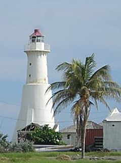
Morant Point Lighthouse is on the easternmost tip of Jamaica.
Plumb Point Lighthouse is an active 19th century heritage lighthouse, located on the Palisadoes a narrow peninsular that connects Port Royal to the mainland. The light helps guide shipping into Kingston Harbour.
Built by the Engineering Department of the Port Authority of Jamaica, Lover's Leap Lighthouse is Jamaica's most recent. It is a 100 feet (30 m) tall cylindrical steel(?) tower with lantern and octagonal gallery. It is powered by three different power sources: a generator, electricity and a set of batteries.
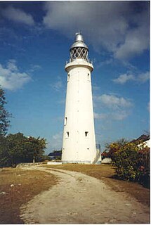
Negril Lighthouse was built in 1894 1.5 miles (2.4 km) south south east of the westernmost tip of the island of Jamaica by the French company Barber & Bernard. It is one of the earliest concrete lighthouses.
Galina Lighthouse is a strongly tapered white concrete tower 13 metres (43 ft) high with no lantern. A solar-powered lens is mounted on a small platform at the top. It shows a white light flashing once every twelve seconds for a duration of 1.2 seconds followed by 10.8 seconds of darkness. The light is visible for 19 kilometres (12 mi). The lighthouse is solar powered.
Rose Hall Lighthouse is a lighthouse on the northernmost tip of Jamaica.
Built in 1888, Folly Lighthouse is a brick tower with lantern and gallery. It flashes a white light every 10 seconds that is visible for 13 miles (21 km). The light is solar powered. A garden surrounds the lighthouse.
Lazaretto Cairn Lighthouse guides vessels westward on their approach to Kingston Harbour. It appears to be a historic daybeacon converted to a lighted aid. It is located on a bluff on the west side of the harbour entrance, opposite Port Royal. It provides the rear light of the Rackhams Cay Range. Its ground is maintained by the Port Authority of Jamaica, an agency of the Ministry of Transport and Works.
Juan de Bolas Mountain in Saint Catherine, Jamaica is named after Juan de Bolas, A Chief of the a Group of Maroonswho sided with the Spanish during the British Spanish war in Jamaica 1655. He was caught by the British and turned to their side a d was instrumental in defeating the Spanish. He would then betrayed the maroons by revealing their settlement to the British and serving as a Maroon Hunter t
