
Southwold Lighthouse is a lighthouse operated by Trinity House in the centre of Southwold in Suffolk, England. It stands on the North Sea coast, acting as a warning light for shipping passing along the east coast and as a guide for vessels navigating to Southwold harbour.

A sector light is a man-made pilotage and position fixing aid that consists of strictly delineated horizontal angle light beams to guide water-borne traffic through a safe channel at night in reasonable visibility. Sector lights are most often used for safe passage through shallow or dangerous waters. This may be when leaving or entering harbour. Nautical charts give all the required information.
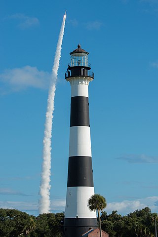
The Cape Canaveral Light is a historic lighthouse on the east coast of the U.S. state of Florida. The light was established in 1848 to warn ships of the dangerous shoals that lie off its coast. It is located inside the Cape Canaveral Space Force Station and managed by the Space Launch Delta 45 of the U.S. Space Force with the assistance of the Cape Canaveral Lighthouse Foundation. It is the only fully operational lighthouse owned by the United States Space Force.
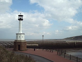
Maryport Lighthouse is a small lighthouse located in Maryport, Cumbria, England, formerly run by England's general lighthouse authority, Trinity House. It is a Grade II listed building.

The Seul Choix Light is a lighthouse located in the northwest corner of Lake Michigan in Schoolcraft County, Michigan. The station was established in 1892 with a temporary light, and this light started service in 1895, and was fully automated in 1972. It is an active aid to navigation. There is now a museum at the light and both the building and the grounds are open for visitors from Memorial Day until the middle of October.

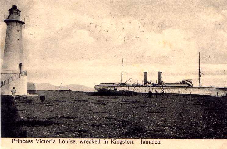
Morant Point Lighthouse is on the easternmost tip of Jamaica, and is the oldest lighthouse on the island.
Portland Cottage light structure formerly Portland Lighthouse sometimes Portland Point Lighthouse is situated on the summit of Portland Ridge, Clarendon, near the southernmost part of Jamaica.
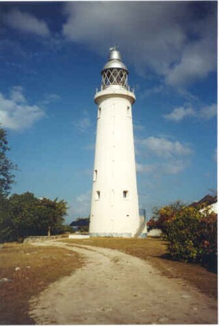
Negril Lighthouse was built in 1894 1.5 miles (2.4 km) south south east of the westernmost tip of the island of Jamaica by the French company Barber & Bernard. It is one of the earliest concrete lighthouses.
Galina Lighthouse is a strongly tapered white concrete tower 13 metres (43 ft) high with no lantern. A solar-powered lens is mounted on a small platform at the top. It shows a white light flashing once every twelve seconds for a duration of 1.2 seconds followed by 10.8 seconds of darkness. The light is visible for 19 kilometres (12 mi). The lighthouse is solar powered.
Built in 1888, Folly Lighthouse is a brick tower with lantern and gallery. It flashes a white light every 10 seconds that is visible for 13 miles (21 km). The light is solar powered. A garden surrounds the lighthouse.
Lazaretto Cairn Lighthouse guides vessels westward on their approach to Kingston Harbour. It appears to be a historic daybeacon converted to a lighted aid. It is located on a bluff on the west side of the harbour entrance, opposite Port Royal. It provides the rear light of the Rackhams Cay Range. Its ground is maintained by the Port Authority of Jamaica, an agency of the Ministry of Transport and Works.
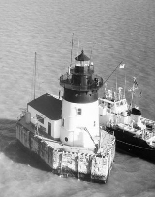
The Detroit River Light, also known as Bar Point Shoal Light, was first established as a lightship in 1875. The current sparkplug lighthouse was built in 1885. It sits in Lake Erie, south of the mouth of the Detroit River, 1.75 nautical miles from land and about 20 nautical miles from the Ambassador Bridge in the Detroit River. It is about 0.4 nautical miles from the border with Canada, and just under 24 nautical miles from Put-in-Bay, Ohio. Its original 4th order Fresnel lens is on loan to the Michigan Maritime Museum.
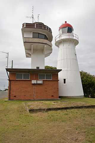
The New Burnett Heads Light, also known as South Head Light, is an active lighthouse standing on the south side of the Burnett River entrance, in Burnett Heads, Queensland, Australia. In 1971 it replaced the Old Burnett Heads Light, which was relocated inland.
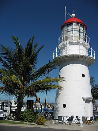
Old Caloundra Light, also known as Old Caloundra Head Light or Cape Caloundra Light, is an inactive lighthouse located in Caloundra on the Sunshine Coast in South East Queensland, Australia. It is the oldest surviving building in Caloundra. The lighthouse was active between 1896 and 1968. The tower was relocated twice. In 1970 it was relocated from its original location to Woorim Park in Caloundra, and in 1999 it was returned to its original site on Canberra Terrace near downtown Caloundra, where it stands today.

Goods Island Light is an active lighthouse located on the highest point of Goods Island (Palilag), an island in the Torres Strait, belonging to Queensland, Australia. It serves as the rear light of the Goods Island Range, pointing out the entrance to Normanby Sound.

Point Cartwright Light is an active lighthouse located on Point Cartwright, a point near the mouth of the Mooloolah River, in Mooloolaba, Queensland, Australia. It marks the entrance to the North West Channel, a deep water channel into Moreton Bay and the Port of Brisbane, and provides guidance into the Mooloolaba Harbour.
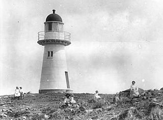
Pine Islet Light, also known as Percy Isles Light, is an active lighthouse located at Pine Islet, a small islet belonging to the Percy Isles group of the Northumberland Islands, about 130 kilometres (81 mi) southeast of Mackay, Queensland, Australia. The original lighthouse, established 1885, was active for a hundred years, until it was deactivated in 1985, by then the last kerosene powered lighthouse in Australia. It was relocated to the Mackay Marina in 1985 and restored to full working condition, making it the last fully functional kerosene operated lighthouse in the world. At the original location now stands a modern fiberglass tower.
Flat Top Island Light is an inactive lighthouse on Flat Top Island, a small island off the entrance to Mackay harbor at the mouth of Pioneer River, about 6.5 kilometres (4.0 mi) east of Mackay, Queensland, Australia. It used to mark the river entrance for shipping and the direction of the port, as well as highlighting close by shoals at Shoalwater Point and a reef off Hay Point. At 6 metres (20 ft) from the ground to the lantern floor, it is the shortest of Queensland's timber-framed iron clad lighthouses.

Dartmouth Harbour is a natural port located in Dartmouth, Devon, England. It is situated at the mouth of the River Dart on the English Channel. Bayard's Cove Fort is a small fort, which was built to defend the harbour's entrance. The crafts which dock at the port are mainly local fishing vessels, naval ships and luxury yachts; warships routinely visit the harbour. The River Dart is navigable from Dartmouth to the old weir location at Totnes.

