
Saint Ann is the largest parish in Jamaica. It is situated on the north coast of the island, in the county of Middlesex, roughly halfway between the eastern and western ends of the island. It is often called "the Garden Parish of Jamaica" on account of its natural floral beauty. Its capital is Saint Ann's Bay. Saint Ann comprises New Seville, the first Spanish settlement in Jamaica.

Saint Thomas, once known as Saint Thomas in the East, is a suburban parish situated at the south eastern end of Jamaica, within the county of Surrey. It is the birthplace of Paul Bogle, designated in 1969 as one of Jamaica's seven National Heroes. Morant Bay, its chief town and capital, is the site of the Morant Bay Rebellion in 1865, of which Bogle was a leader.

Negril is a small, widely dispersed beach resort and town located in Westmoreland and Hanover parishes at the far western part of Jamaica, 80.8 kilometres (50.2 mi) southwest from Sangster International Airport in Montego Bay.

Clarendon is a parish in Jamaica. It is located on the south of the island, roughly halfway between the island's eastern and western ends. Located in the county of Middlesex, it is bordered by Manchester on the west, Saint Catherine in the east, and in the north by Saint Ann. Its capital and largest town is May Pen.

Portland, with its capital town Port Antonio, is a parish located on Jamaica's northeast coast. It is situated to the north of St Thomas and to the east of St Mary in Surrey County. It is one of the rural areas of Jamaica, containing part of the Blue Mountains, where the Jamaican Maroon communities of Moore Town and Charles Town are located.
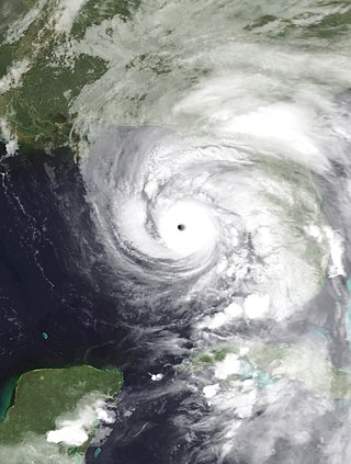
Hurricane Dennis was a deadly and destructive tropical cyclone that briefly held the record for the strongest Atlantic hurricane ever to form before August. Dennis was the fourth named storm of the record-breaking 2005 Atlantic hurricane season. It originated on July 4 near the Windward Islands from a tropical wave. Dennis intensified into a hurricane on July 6 as it moved across the Caribbean Sea. Two days later, it became a strong Category 4 hurricane on the Saffir-Simpson scale before striking Cuba twice on July 8. After weakening over land, Dennis re-intensified in the Gulf of Mexico, attaining its lowest barometric pressure of 930 mbar (27 inHg) on July 10. That day, Dennis weakened slightly before making a final landfall on Santa Rosa Island, Florida as a Category 3 hurricane. Six days later, Dennis's record intensity was surpassed by Hurricane Emily. After moving through the central United States, the circulation associated with former Hurricane Dennis dissipated on July 18 over Ontario.

Tufts Medical Center station is an underground Massachusetts Bay Transportation Authority (MBTA) rapid transit station in Boston, Massachusetts. It serves the MBTA subway Orange Line, as well as two Silver Line bus rapid transit routes on the surface. It is named for the Tufts Medical Center and is built under a wing of the facility that crosses over Washington Street in downtown Boston between Kneeland Street in Chinatown and the Massachusetts Turnpike. The accessible station has two side platforms for the Orange Line.

Hanover is a parish located on the northwestern tip of the island of Jamaica. It is a part of the county of Cornwall, bordered by St. James in the east and Westmoreland in the south. With the exception of Kingston, it is the smallest parish on the island. Hanover is the birth parish of Alexander Bustamante, labour leader, first head of government of Jamaica under universal suffrage, and one of seven Jamaican National Heroes. Its capital is Lucea.
Port Antonio is the capital of the parish of Portland on the northeastern coast of Jamaica, about 100 km from Kingston. It had a population of 12,285 in 1982 and 13,246 in 1991. It is the island's third largest port, famous as a shipping point for bananas and coconuts, as well as one of its most important tourist attractions, tourism being a major contributor to the town's economy.

Corpus Christi Bay is a scenic semi-tropical bay on the Texas coast found in San Patricio and Nueces counties, next to the major city of Corpus Christi. It is separated from the Gulf of Mexico by Mustang Island, and is fed by the Nueces River and Oso Creek from its western and southern extensions, Nueces Bay and Oso Bay. The bay is located approximately 136 miles (219 km) south of San Antonio, and 179 miles (288 km) southwest of Houston.
Orange Bay is a small bay in Portland Parish, Jamaica, fifteen miles west of the capital, Port Antonio. The name is shared by a small village on the shore of the bay.

Perdido Pass, separating Alabama Point from Florida Point, is the mouth of the Perdido River. Perdido Pass forms a water passage that connects Perdido Bay with the Gulf of Mexico to the south, in the U.S. state of Alabama, 2 miles (3 km) west of the Alabama/Florida state line. A bridge spans Perdido Pass, connecting Alabama Point with Florida Point in Alabama. At the entrance into the Gulf, the 2 rock barriers, extending from the white beaches, are the west jetty & east jetty. The surrounding area is heavily developed, with high-rise condominiums. However, there are nearby beach-front parks, with Gulf State Park on the eastern side of Perdido Pass.

Portland Island is an island of the Southern Gulf Islands of the South Coast of British Columbia, Canada. It is located in the Salish Sea west of Moresby Island and off the south tip of Saltspring Island, adjacent to the main BC Ferries route just offshore from the terminal at Swartz Bay at the tip of the Saanich Peninsula. It was named after HMS Portland, the flagship of Rear-Admiral Fairfax Moresby, Commander in Chief of the Pacific Station 1850–1853.
San San is a town in the parish of Portland in Jamaica.

Simonds is a geographic parish in Saint John County, New Brunswick, Canada.

The 1944 Jamaica hurricane was a deadly major hurricane that swept across the Caribbean Sea and Gulf of Mexico in August 1944. Conservative estimates placed the storm's death toll at 116. The storm was already well-developed when it was first noted passing westward over the Windward Islands into the Caribbean Sea on August 16. A ship near Grenada with 74 occupants was lost, constituting a majority of the deaths associated with the storm. The following day, the storm intensified into a hurricane, reaching its peak strength on August 20 with maximum sustained winds of 120 mph (195 km/h). At this intensity, the major hurricane made landfall on Jamaica later that day, traversing the length of the island. The damage wrought was extensive, with the strong winds destroying 90 percent of banana trees and 41 percent of coconut trees in Jamaica; the overall damage toll was estimated at "several millions of dollars". The northern coast of Jamaica saw the most severe damage, with widespread structural damage and numerous homes destroyed across several parishes. In Port Maria, the storm was considered the worst since 1903.