
Jamaica lies 140 km (87 mi) south of Cuba and 190 km (118 mi) west of Haiti. At its greatest extent, Jamaica is 235 km (146 mi) long, and its width varies between 34 and 84 km. Jamaica has a small area of 10,992 km2 (4,244 sq mi). However, Jamaica is the largest island of the Commonwealth Caribbean and the third largest of the Greater Antilles, after Cuba and Hispaniola. Many small islands are located along the south coast of Jamaica, such as the Port Royal Cays. Southwest of mainland Jamaica lies Pedro Bank, an area of shallow seas, with a number of cays, extending generally east to west for over 160 km (99 mi). To the southeast lies Morant Bank, with the Morant Cays, 51 km (32 mi) from Morant Point, the easternmost point of mainland Jamaica. Alice Shoal, 260 km (160 mi) southwest of the main island of Jamaica, falls within the Jamaica–Colombia Joint Regime. It has an Exclusive Economic Zone of 258,137 km2 (99,667 sq mi).

Kangchenjunga, also spelled Kanchenjunga, Kanchanjanghā and Khangchendzonga, is the third-highest mountain in the world. Its summit lies at 8,586 m (28,169 ft) in a section of the Himalayas, the Kangchenjunga Himal, which is bounded in the west by the Tamur River, in the north by the Lhonak River and Jongsang La, and in the east by the Teesta River. It lies in the border region between Koshi Province of Nepal and Sikkim state of India, with three of the five peaks, namely Main, Central and South, directly on the border, and the peaks West and Kangbachen in Nepal's Taplejung District.

Swallowtail butterflies are large, colorful butterflies in the family Papilionidae, and include over 550 species. Though the majority are tropical, members of the family inhabit every continent except Antarctica. The family includes the largest butterflies in the world, the birdwing butterflies of the genus Ornithoptera.

Hibiscus rosa-sinensis, known colloquially as Chinese hibiscus, China rose, Hawaiian hibiscus, rose mallow and shoeblack plant, is a species of tropical hibiscus, a flowering plant in the Hibisceae tribe of the family Malvaceae. It is widely cultivated as an ornamental plant in the tropics and subtropics.

Sir Henry Arthur Blake was a British colonial administrator and Governor of Hong Kong from 1898 to 1903.
Dinara is a 100-kilometre-long (60-mile) mountain range in the Dinaric Alps, located on the border of Bosnia and Herzegovina and Croatia. It has four major mountains or peaks, from north-west to south-east:

Mount of the Holy Cross is a high and prominent mountain summit in the northern Sawatch Range of the Rocky Mountains of North America. The 14,011-foot (4270.5 m) fourteener is located in the Holy Cross Wilderness of White River National Forest, 6.6 miles (10.7 km) west-southwest of the Town of Red Cliff in Eagle County, Colorado, United States. The summit of Mount of the Holy Cross is the highest point in Eagle County and the northern Sawatch Range.

The Blue Mountains are the longest mountain range in Jamaica. They include the island's highest point, Blue Mountain Peak, at 2256 m (7402 ft). From the summit, accessible via a walking track, both the north and south coasts of the island can be seen. On a clear day, the outline of the island of Cuba, 210 km (130 mi) away, can also be seen. The mountain range spans four parishes: Portland, St. Thomas, St. Mary and St. Andrew.

Blue Mountain Peak is the highest mountain in Jamaica and one of the highest peaks in the Caribbean at 2,256 metres (7,402 ft). It is the home of Blue Mountain coffee. It is located on the border of the Portland and Saint Thomas parishes of Jamaica.

Mount Colvin is the 39th highest peak in the High Peaks Region of the Adirondack Mountains in the U.S. State of New York. Mount Colvin offers excellent views of a number of other Adirondack High Peaks, most notably the peaks that comprise the Great Range. High Peaks that are readily visible from Colvin include Giant, Rocky Peak Ridge, Upper Wolfjaw, Lower Wolfjaw, Armstrong, Sawteeth, Gothics, Saddleback, Basin, Tabletop, Marcy, Haystack, Redfield, Allen, Nippletop, Dial and Blake.

The Schreckhorn is a mountain in the Bernese Alps. It is the highest peak located entirely in the canton of Bern. The Schreckhorn is the northernmost Alpine four-thousander and the northernmost summit rising above 4,000 metres in Europe.
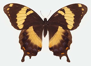
Papilio homerus, commonly known as the Homerus swallowtail or Jamaican swallowtail, is the largest butterfly species in the Western Hemisphere. The species is endangered and faces a potentially bleak future. Only two small populations of the Homerus swallowtail remain in a fraction of their original environment. It is endemic to Jamaica where the butterfly simultaneously serves as an icon of national pride and a need for conservation efforts. Over the past half century, the Jamaican swallowtail has been featured on various postal stamps and the Jamaican $1000 bill. In the face of rapid habitat destruction from human disruption and illegal collecting, the Jamaican swallowtail is listed on the Threatened Swallowtail Butterflies of the World by the International Union for Conservation of Nature and is protected under international and national level legislation.

The Preakness Range is a range of the trap rock Watchung Mountains on the western edge of the Newark Basin in northern New Jersey. A large portion of this range is included in High Mountain Park Preserve, offering miles of hiking trails with vistas overlooking New Jersey and New York City. The peaks of the Preakness Range, the highest of the Watchung Mountains, shelter endangered ecosystems, including perched wetlands and rare trap rock glade communities.

Sarnoff Mountains is a range of mountains, 251 nautical miles long and 4 to 8 nautical miles wide separating the west-flowing Boyd Glacier and Arthur Glacier in the Ford Ranges of Marie Byrd Land, Antarctica.
Blue and John Crow Mountains National Park is a national park in Jamaica. The park covers 495.2 km2 and accounts for 4.5% of Jamaica's land surface. It gets its name from the Blue Mountains, the mountain range that runs through it, as well as a common bird found in the park, the "John crow" or turkey vulture. The park is globally known for its biodiversity. This park is the last of two known habitats of the giant swallowtail butterfly, the largest butterfly in the Western Hemisphere and also the habitat for the endangered Jamaican blackbird, a refuge for the Jamaican boa and the Jamaican hutia.

The Jamaican moist forests is a tropical and subtropical moist broadleaf forests ecoregion in Jamaica.

Black Giant is a 13,330-foot-elevation (4,060-meter) mountain summit located west of the crest of the Sierra Nevada mountain range, in Fresno County of central California, United States. Black Giant ranks as the 86th highest summit in California. It is the northernmost and highest summit on its namesake ridge, the Black Divide in northern Kings Canyon National Park. The peak is situated 3.9 miles (6.3 km) east of Mount Goddard, and 2.6 miles (4.2 km) south-southeast of Mount Fiske, which is the nearest higher neighbor. Topographic relief is significant as it rises 4,000 feet above Le Conte Canyon in approximately two miles. Muir Pass is 1.4 miles (2.3 km) to the northwest, and the approach to this remote peak is made via the John Muir Trail.

Mount Haeckel is a 13,424-foot (4,092 m) mountain summit located on the crest of the Sierra Nevada mountain range in northern California, United States. It is situated on the shared boundary of Kings Canyon National Park with John Muir Wilderness, and along the common border of Fresno County with Inyo County. It is 21.5 miles (34.6 km) west of the community of Big Pine, 1.27 miles (2.04 km) south-southeast of Mount Darwin, and one mile north-northeast of Mount Fiske, which is the nearest higher neighbor. Mount Haeckel ranks as the 71st highest summit in California.
