
Mount Diablo is a mountain of the Diablo Range, in Contra Costa County of the eastern San Francisco Bay Area in Northern California. It is south of Clayton and northeast of Danville. It is an isolated upthrust peak of 3,849 feet, visible from most of the San Francisco Bay Area. Mount Diablo appears from many angles to be a double pyramid and has many subsidiary peaks. The largest and closest is North Peak, the other half of the double pyramid, which is nearly as high in elevation at 3,557 feet (1,084 m), and is about one mile northeast of the main summit.

Junipero Serra Peak is the highest mountain in the Santa Lucia range of central California with a height of 1,785 metres. It is also the highest peak in Monterey County, and is located within the boundaries of Los Padres National Forest. It is named after Saint Junípero Serra, the Spanish Franciscan priest who founded the California Missions in the 18th century. There is a fire lookout, with a tower and building, near the peak that was constructed around 1935. An unauthorized skiing operation on the summit was reported sometime before 1970. Good astronomical observing conditions were an early attraction to the peak. Astronomers scratched a trail to the summit in January 1880 to observe a total eclipse of the sun. Observations from the peak were also made on the transit of Venus in 1882.

Mount Hamilton is a mountain in the Diablo Range in Santa Clara County, California. The mountain's peak, at 4,265 feet (1,300 m), overlooks the heavily urbanized Santa Clara Valley and is the site of Lick Observatory, the world's first permanently occupied mountain-top observatory. The asteroid 452 Hamiltonia, discovered in 1899, is named after the mountain. Golden eagle nesting sites are found on the slopes of Mount Hamilton. On clear days, Mount Tamalpais, the Santa Cruz Mountains, Monterey Bay, the Monterey Peninsula, and even Yosemite National Park are visible from the summit of the mountain.
There are several places named Devil's Peak, Devils Peak or Devil Peak.
The White Pine Range is a group of mountains in southern White Pine County, in eastern Nevada. The range runs for approximately 51 miles (82 km) from Beck Pass in the north to Currant Pass in the south. To the west of the range are the Duckwater (Shoshone) tribal lands and the northern arm of large Railroad Valley. To the east are Jakes Valley and the northern part of the long White River Valley. To the south are the Horse and Grant Ranges.

Whiteside Mountain or Sanigilâ'gĭ in Cherokee is a mountain in Jackson County, North Carolina between Cashiers, Highlands, North Carolina, and the Georgia border. Whiteside Mountain can boast the highest cliffs in Eastern North America. It also has a feature called Devil's Courthouse, not to be confused with the Devil's Courthouse 20 miles away in Transylvania County, NC.

Devil's Head Lookout is a U.S. Forest Service fire lookout tower at the summit of Devils Head in Douglas County, Colorado. Located on a large pinnacle of Pikes Peak granite, the fire lookout point lies within the Pike National Forest and is accessed by hiking the Devils Head National Recreation Trail.

Devils Head is a mountain summit in the Rampart Range of the Rocky Mountains of Colorado. The 9,749-foot (2,971 m) peak is located in Pike National Forest, 14.2 miles (22.9 km) southwest by south of the community of Sedalia in Douglas County, Colorado, United States.
Suicide Rock is a granite outcrop near Idyllwild, California, which is popular with rock climbers. Over three hundred climbing routes have been described. It is located near Tahquitz Peak.
Sex Peak is a summit in Sanders County, Montana, in the United States. It is located within the Kootenai National Forest. It has an elevation of 5,751 feet (1,753 m)
Middle Widows Peak is a summit in the U.S. state of Nevada. The elevation is 4,081 feet (1,244 m).
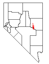
North Peak is a summit in the U.S. state of Nevada. The elevation is 4,911 feet (1,497 m).
East Peak is a summit in Elko County in the U.S. state of Nevada. The elevation is 6,194 feet (1,888 m). The peak rises above the Humboldt River valley and the community of Ryndon about two miles to the north and the main peak of Elko Mountain is about two miles to the west-southwest.
Elk Mountain is a summit in Elko County in the U.S. state of Nevada. The elevation is 8,802 feet (2,683 m). The peak is in the northeastern portion of the Humboldt-Toiyabe National Forest about two miles south of the Nevada - Idaho border.
Tordillo Mountain is a lone summit that rises to the elevation of 2,064 feet in Yuma County, Arizona.
Joaquin Ridge is a ridge in the Diablo Range in Fresno County, California. The ridge is named for Joaquin Murietta (1830-1853), a California Gold Rush bandit, leader of the Five Joaquins Gang, who used this region as a rendezvous and camp that overlooked the gangs base at the Rancho de Cantua. The ridge is ten miles long, running from its high point at 36°19′48″N120°34′09″W, east of Spanish Lake, eastward to Joaquin Rocks 36°19′11″N120°27′32″W, and then southwestward to 36°18′15″N120°24′11″W near 3,629-foot Black Mountain at 36°18′16″N120°24′12″W the high point on the south southeast trending Anticline Ridge. Joaquin Ridge is bound on the northeast by the Ragged Valley and the Big Blue Hills and on the southwest by Portuguese Canyon. Its highest elevation is 4,701 feet, 0.64 km (0.40 mi) east of Spanish Lake.
Joaquin Spring, originally known as Valenzuela Spring, is a spring on Joaquin Ridge in the Diablo Range in Fresno County, California. The spring is located on the southwestern slope of the ridge, about 500 feet below Joaquin Rocks, at an elevation of 3,520 feet.
Graveyard Peak is an 11,539-foot-elevation (3,517 meter) mountain summit located in the Sierra Nevada mountain range in Fresno County of northern California, United States. It is situated in the John Muir Wilderness, on land managed by Sierra National Forest. Graveyard Peak ranks as the 535th-highest summit in California, and topographic relief is significant as the south aspect rises over 2,300 feet above Devils Bathtub in approximately one mile. It is two miles southeast of Silver Peak, five miles north of Lake Thomas A Edison, and approximately 13 miles (21 km) south of the community of Mammoth Lakes. The peak is set on Silver Divide, so precipitation runoff from the north side of this mountain drains into Fish Creek which is a tributary of the San Joaquin River, and from the south slope to Lake Thomas A Edison. The peak is most easily reached out of Lake Thomas Edison.
