Mount Dispersion, New South Wales

Last updated

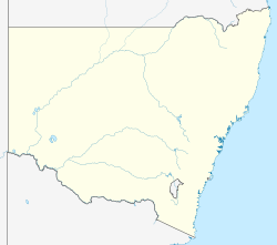
Australia New South Wales location map blank.svg
Red pog.svg
Mount Dispersion
Location in New South Wales

Mount Dispersion, in south-western New South Wales, is the location of the massacre of Aboriginal Australians by Major Thomas Mitchell on 27 May 1836. Officially recognised as an Aboriginal place under the National Parks and Wildlife Act 1974 in May 2020, the official name is the Mount Dispersion Massacre Site Aboriginal Place.

Contents

History

In May 1836 Mitchell and his surveying party had been followed for several days by a group of Aboriginal people, starting from Lake Benanee, near the present-day town of Euston. Although it is not exactly clear what happened, it seems that instead of attempting negotiation, Mitchell and his men decided to launch a surprise attack on 27 May. [1] In Mitchell's words:

it was difficult to come at such enemies hovering in our rear with lynx-eyed vigilance of savages. I succeeded however... Attacked simultaneously by both parties the whole betook themselves to the river, my men pursuing them and shooting as many as they could, Numbers were shot swimming across the Murray, and some ever after they had reached the opposite shore as they descended they bank. [2]

There were at least seven Aboriginal people killed as they fled across the Murray River. Mitchell faced an enquiry in Sydney afterwards, so his account was recorded, but that of the survivors was not. [3] Mitchell received only a minor reprimand for his actions. [4]

Mitchell named the small hill Mount Dispersion. [1]

Mitchell later published a book in which he justified the event by emphasising that the ambush was an act of self-defence: he portrayed the Aboriginal people as hostile tribes from the Darling River intent on revenge for an incident during his 1835 expedition in which his party shot and wounded a man, and killed another man and a woman who was carrying a baby. [4]

Recognition

A monument in the form of a cairn was built by the Mildura Historical Society in September 1963, with the inscription "Mt Dispersion / Named by Major Mitchell on May 26th 1836 after an encounter with Aboriginies[sic] at this spot"; [2] however, it was placed 2 kilometres (1.2 mi) from the correct location. [1]

The same site had been known as a sacred site for thousands of years by the Kureinji and Barkindji peoples, with a songline relating to "the story of the great warrior and the cod and the spiritual ancestors" connected to it. Mutti Mutti elder Barry Pearce, who lives nearby, believes that knowledge of history such as this, and acknowledgement of Australian frontier wars, helps reconciliation, and would also like visitors to know about the cultural history of the spot - that it is "more than the massacre". He was inspired to have the site acknowledged, and Heritage NSW officer Harvey Johnston led a project to have it formally recognised on the New South Wales State Heritage Register. [1]

On 24 April 2020, Mount Dispersion was recorded in the New South Wales Government Gazette as an Aboriginal Place under the National Parks and Wildlife Act 1974 (NSW). [4] [5] It was officially listed on 27 May 2020, 184 years to the day that the massacre took place. [1]

Location

Mount Dispersion is close to the border with Victoria, on Tapalin Mail Road. It lies on a former course of the Murray, near Euston. [4]

Related Research Articles

<span class="mw-page-title-main">Blue Mountains (New South Wales)</span> Mountain range in New South Wales, Australia

The Blue Mountains are a mountainous region and a mountain range located in New South Wales, Australia. The region is considered to be part of the western outskirts of the Greater Sydney area. The region borders on Sydney's main metropolitan area, its foothills starting about 50 kilometres (31 mi) west of centre of the state capital, close to Penrith. The public's understanding of the extent of the Blue Mountains is varied, as it forms only part of an extensive mountainous area associated with the Great Dividing Range. As defined in 1970, the Blue Mountains region is bounded by the Nepean and Hawkesbury rivers in the east, the Coxs River and Lake Burragorang to the west and south, and the Wolgan and Colo rivers to the north. Geologically, it is situated in the central parts of the Sydney Basin.

This article describes the history of the Australian colony and state of Victoria.

<span class="mw-page-title-main">Thomas Mitchell (explorer)</span> Scottish surveyor and explorer of south-eastern Australia (1792-1855)

Sir Thomas Livingstone Mitchell, often called Major Mitchell, was a Scottish surveyor and explorer of Southeastern Australia. He was born in Scotland and served in the British Army during the Peninsular War. In 1827 he took up an appointment as Assistant Surveyor General of New South Wales. The following year he became Surveyor General and remained in this position until his death. Mitchell was knighted in 1839 for his contribution to the surveying of Australia.

<span class="mw-page-title-main">Bingara, New South Wales</span> Town in New South Wales, Australia

Bingara is a small town on the Gwydir River in Murchison County in the New England region of New South Wales, Australia. Bingara is currently the administrative centre for the Gwydir Shire that was created in 2003. The Gwydir River being a main highlight of the town is a main catchment of the Murray-Darling System.

<span class="mw-page-title-main">Waterloo Creek massacre</span> Massacre of Australian Gamilaraay peoples 1837–1838

The Waterloo Creek massacre refers to a series of violent clashes between mounted police, civilian vigilantes and Indigenous Gamilaraay peoples, which occurred southwest of Moree, New South Wales, Australia, during December 1837 and January 1838. The Waterloo Creek Massacre site is listed on the New South Wales Heritage Register as a place of significance in frontier violence leading to the murder of Gamilaraay people. The events have been subject to much dispute, due to wildly conflicting accounts by various participants and in subsequent reports and historical analyses, about the nature and number of fatalities and the lawfulness of the actions. Interpretation of the events at Waterloo Creek was raised again during the controversial "history wars" which began in the 1990s in Australia.

<span class="mw-page-title-main">Menindee, New South Wales</span> Town in New South Wales, Australia

Menindee is a small town in the far west of New South Wales, Australia, in Central Darling Shire, on the banks of the Darling River, with a sign-posted population of 980 and a 2016 census population of 551. Menindee was the first town to be established on the Darling River. There are two distinct theories for the derivation of the township’s name: (a) from the Barkindji word "minandichi" for the shallow ephemeral lake north-west of the present-day township; (b) from the Barkindji word 'milhthaka', meaning "yolk of an egg".

The Surveyor General of New South Wales is the primary government authority responsible for land and mining surveying in New South Wales.

<span class="mw-page-title-main">Pinjarra massacre</span> 1834 killing of Binjareb Noonga people by colonists in Pinjarra, Western Australia

The Pinjarra massacre, also known as the Battle of Pinjarra, occurred on 28 October 1834 in Pinjarra, Western Australia when a group of Binjareb Noongar people were attacked by a detachment of 25 soldiers, police, and settlers led by Governor James Stirling. According to Stirling, "about 60 or 70" of the Binjareb people were present at the camp and John Roe, who also participated, estimated about 70–80. This roughly agrees with an estimate of 70 by an unidentified eyewitness. The attack at Pinjarra was in response to sustained aggression by the Binjarebs, including robberies and murder of settlers and members of other Nyungar tribes.

<span class="mw-page-title-main">Wentworth Gaol</span>

The Wentworth Gaol is a heritage-listed former gaol and school building and now museum and old wares shop located at 112 Beverley Street, Wentworth, in the Wentworth Shire, New South Wales, Australia. It was designed by James Barnet and built from 1879 to 1881 by Whitcombe Brothers, Hay. It is also known as the Old Wentworth Gaol. The property is owned by Department of Primary Industries - Western Lands Commissioner, an agency of the Government of New South Wales. The property was added to the New South Wales State Heritage Register on 21 October 2016.

The following lists events that happened during 1836 in Australia.

The Hornet Bank massacre was the killing of eleven settlers and one Aboriginal station-hand, by a group of Iman Aboriginal Australians. The massacre occurred at about one or two o'clock in the morning of 27 October 1857 at Hornet Bank station on the upper Dawson River near Eurombah in central Queensland, Australia. It has been moderately estimated that 150 Aboriginal people succumbed in subsequent punitive missions conducted by Native Police, private settler militias, and by William Fraser in or around Eurombah district. Indiscriminate shootings of "over 300" Aboriginal men, women, and children, however, were reportedly conducted by private punitive expedition some 400 kilometres eastward at various stations in the Wide Bay district alone. The result was the believed extermination of the entire Iman tribe and language group by 1858; this claim was disputed, however, and descendants of this group have recently been recognised by the High Court of Australia to be the original custodians of the land surrounding the town of Taroom.

The Convincing Ground Massacre was a massacre of the Indigenous Gunditjmara people Kilcarer gundidj clan by British settler whalers based at Portland Bay in South-Eastern Australia. It was part of the wider Eumeralla Wars between the British colonisers and Gunditjmara. Tensions between the two groups had been building since the establishment of the town as a whaling station some five years previously, however, around 1833 or 1834, a dispute over a beached whale caused events to escalate.

<span class="mw-page-title-main">Narran Wetlands</span> Protected area in New South Wales, Australia

The Narran Wetlands, also known as the Narran Lakes, contained within the Narran Lake Nature Reserve, comprise a series of protected ephemeral lakes and swamps fed by the Narran River in the north-west of New South Wales, Australia. The 26,480-hectare (65,400-acre) reserve is located approximately 50 kilometres (31 mi) east of Brewarrina.

<span class="mw-page-title-main">Muthi Muthi</span>

The Muthi Muthi people are an indigenous Australian people whose traditional lands are located in the Northern Riverina and Far West regions of New South Wales.

<span class="mw-page-title-main">Kureinji</span> Place in New South Wales, Australia

The Kureinji, otherwise known as the Keramin, are an Aboriginal group whose traditional lands are located in southwest New South Wales, Australia, along the north side of the Murray River roughly between today's settlements of Euston and Wentworth.

<span class="mw-page-title-main">Myall Creek Massacre and Memorial Site</span> Historic site in New South Wales, Australia

Myall Creek Massacre and Memorial Site is the heritage-listed site of and memorial for the victims of the Myall Creek massacre at Bingara Delungra Road, Myall Creek, Gwydir Shire, New South Wales, Australia. The memorial, which was unveiled in 2000, was added to the Australian National Heritage List on 7 June 2008 and the New South Wales State Heritage Register on 12 November 2010.

Criminal activity in New South Wales, Australia is combated by the New South Wales Police Force and the New South Wales court system, while statistics about crime are managed by the NSW Bureau of Crime Statistics and Research. Modern Australian states and cities, including New South Wales, have some of the lowest crime rates recorded globally with Australia ranked the 13th safest nation and Sydney ranked the 5th safest city globally. As of September 2018 the City of Penrith (475.7) and City of Blacktown (495.1). Rural areas have comparatively high crime rates per 100,000 with rural shires such as Walgett Shire (1350.3) and Moree Plains Shire (1236.2) having some of the highest violent crime rates in the state. The overall NSW crime rate has been in steady decline for many years.

Myall Creek is a locality split between the local government areas of Inverell Shire and the Gwydir Shire in New South Wales, Australia. In the 2016 census, Myall Creek had a population of 38 people.

<span class="mw-page-title-main">James Larmer</span>

James Larmer was a government surveyor in the colony of New South Wales. Between 1830 and 1859, he surveyed land, roads and settlements in New South Wales. He was an Assistant Surveyor to the Surveyor-General, Sir Thomas Mitchell, from 1835 to 1855. In 1835, he was second in command of Mitchell’s second expedition. He is also noteworthy for his recording of Aboriginal words from various parts of New South Wales.

References

  1. 1 2 3 4 5 Testa, Christopher (3 June 2020). "NSW Government recognises site of Mount Dispersion's 'bloody and vicious' massacre of Aboriginal people". ABC News. Australian Broadcasting Corporation. Retrieved 7 July 2020.
  2. 1 2 "Mount Dispersion Cairn". Monument Australia. Retrieved 7 July 2020.
  3. "Mount Dispersion recognised as a Declared Aboriginal Place". Australian Frontier Conflicts. 24 April 2020. Retrieved 7 July 2020.
  4. 1 2 3 4 "Mount Dispersion Massacre Site Aboriginal Place". NSW Office of Environment & Heritage. Retrieved 7 July 2020. CC-BY icon.svg Text was copied from this source, which is available under a Attribution 4.0 International (CC BY 4.0) licence. (See here).
  5. Government Gazette of the State of New South Wales, No 85, Friday 24 April 2020

Further reading

34°34′18″S142°28′29″E / 34.57167°S 142.47472°E / -34.57167; 142.47472