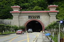
Mount Erlang Tunnel

Last updated
Mount Erlang Tunnel
Erlang Mountain Tunnel (G318).jpg
The tunnel in 2010.
Overview
Route China National Highway 318
Operation
OpenedDecember 8, 1999 (1999-12-08)
2018 (2018)
Technical
Length13,433 metres (44,071.5 ft)
No. of lanes 2
Erlangshan Tunnel Road Sign Erlangshan-tunnel.jpg
Erlangshan Tunnel Road Sign

The Mount Erlang Tunnel is a road tunnel along Sichuan-Tibet Highway (China National Highway 318), which connects China's Sichuan Province and Tibet Autonomous Region. The tunnel is 4,176 meters long and was dug through Mount Erlang in Sichuan Province. [1]

Contents

It opened on December 8, 1999. Construction took three years and cost 470 million yuan (56.6 million US dollars).

It was built to reduce time and replaces one of the most dangerous parts of the highway, which had frequent accidents because of landslides, rain and foggy weather. [1]

New Tunnel

Erlangshan extra-long tunnel under the same mountain was completed in 2018. It is a part of the Yakang Expressway and has a total length of 13 433 metres, making it the 11th longest road tunnel in the world as of 2021. [2] The tunnel passes through several seismic fault zones and its deeperts parts are 1 500 metres underground. [3] At its western end, the tunnel links up with the Xingkang Bridge. [4]

Related Research Articles

<span class="mw-page-title-main">Sichuan Basin</span> Basin in Sichuan, China

The Sichuan Basin, formerly transliterated as the Szechwan Basin, sometimes called the Red Basin, is a lowland region in southwestern China. It is surrounded by mountains on all sides and is drained by the upper Yangtze River and its tributaries. The basin is anchored by Chengdu, the capital of Sichuan province, in the west, and the direct-administered municipality of Chongqing in the east. Due to its relative flatness and fertile soils, it is able to support a population of more than 100 million. In addition to being a dominant geographical feature of the region, the Sichuan Basin also constitutes a cultural sphere that is distinguished by its own unique customs, cuisine and dialects. It is famous for its rice cultivation and is often considered the breadbasket of China. In the 21st century its industrial base is expanding with growth in the high-tech, aerospace, and petroleum industries.

<span class="mw-page-title-main">Ya'an</span> Prefecture-level city in Sichuan, Peoples Republic of China

Ya'an is a prefecture-level city in the western part of Sichuan province, China, located just below the Tibetan Plateau. The city is home to Sichuan Agricultural University, the only 211 Project university and the largest regional comprehensive university in Ya'an. As of the 2020 Chinese census, Ya'an has a population of 1,434,603.

<span class="mw-page-title-main">Dagzê, Lhasa</span> District in Tibet, China

Dagzê District is a district of Lhasa immediately east of the district of Chengguan, Tibet. The Lhasa River runs through the district. As of 2013 the total population was 29,152, mostly ethnic Tibetans engaged in agriculture. The district is home to the Ganden and Yerpa monasteries.

<span class="mw-page-title-main">Hengduan Mountains</span> Mountain range in southwest China

The Hengduan Mountains are a group of mountain ranges in southwest China that connect the southeast portions of the Tibetan Plateau with the Yunnan–Guizhou Plateau. The Hengduan Mountains are primarily large north-south mountain ranges that effectively separate lowlands in northern Myanmar from the lowlands of the Sichuan Basin. These ranges are characterized by significant vertical relief originating from the Indian subcontinent's collision with the Eurasian Plate, and further carved out by the major rivers draining the eastern Tibetan Plateau. These rivers, the Yangtze, Mekong, and Salween, are recognized today as the Three Parallel Rivers UNESCO World Heritage Site.

<span class="mw-page-title-main">Lhasa Gonggar Airport</span> Airport in Tibet, China

Lhasa Gonggar Airport is the airport serving Lhasa, the capital city of the Tibet Autonomous Region, People's Republic of China. It is about 97 kilometres (60 mi) to Lhasa and about 62 kilometres (39 mi) southwest of the city in Gyazhugling, Gonggar County of Shannan.

<span class="mw-page-title-main">China Road and Bridge Corporation</span> Chinese construction company

China Road and Bridge Corporation (CRBC), a subsidiary of Fortune Global 500 company China Communications Construction Company (CCCC), focuses on global civil engineering and construction projects such as highways, railways, bridges, ports, and tunnels. Growing out of the Foreign Aid Office of the Ministry of Communications of China, CRBC and its predecessors have been executing projects since 1958. In 1979, CRBC was formally established and entered the international contracting market. The parent entity, CCCC, was formed through the combination of CRBC and China Harbour Engineering Company Ltd (CHEC) in 2005.

<span class="mw-page-title-main">Mount Erlang</span>

Mount Erlang is a mountain in Sichuan province, China.

<span class="mw-page-title-main">China National Highway 318</span> Road in China

China National Highway 318 (G318) runs from Shanghai to Zhangmu on the China-Nepal border. It is the longest China National Highway at 5,476 kilometres (3,403 mi) in length and runs west from Shanghai towards Zhejiang, Anhui, Hubei, Chongqing, Sichuan, and ends in Tibet Autonomous Region. From Lhasa to Zhangmu it is also called Friendship Highway. From Markam to Zogang it shares the highway with G214. At the Sino-Nepal Friendship Bridge, it connects with the 115 km long Araniko Highway to Kathmandu.

<span class="mw-page-title-main">Aizhai Bridge</span> Bridge in Jishou

The Aizhai Bridge is a suspension bridge on the G65 Baotou–Maoming Expressway near Jishou, Hunan, China. The bridge was built as part of an expressway from southwest China's Chongqing Municipality to Changsha.

<span class="mw-page-title-main">Bridges and tunnels across the Yangtze River</span>

The bridges and tunnels across the Yangtze River carry rail and road traffic across China's longest and largest river and form a vital part of the country's transportation infrastructure. The river bisects China proper from west to east, and every major north–south bound highway and railway must cross the Yangtze. Large urban centers along the river such as Chongqing, Wuhan, and Nanjing also have urban mass transit rail lines crossing the Yangtze.

<span class="mw-page-title-main">Yichang–Wanzhou railway</span> Railway line in China

The Yichang–Wanzhou railway, or the Yiwan railway connects the cities of Yichang and Wanzhou via Lichuan, Hubei. It was completed in 2010 and forms part of the Shanghai–Wuhan–Chengdu passenger railway. Out of the line's total 377 km (234 mi) length, 288 km (179 mi) runs on bridges or in tunnels. According to the chief engineer, Zhang Mei, the line was the most difficult ever constructed in China. Operation started on 22 December 2010.

Chongqing Road Engineering Group is one of the largest individually owned construction groups in the western China region. The company's headquarters is in Yubei District of Chongqing, a provincial-level municipality of the People's Republic of China.

<span class="mw-page-title-main">G42 Shanghai–Chengdu Expressway</span> Expressway of China

The Shanghai–Chengdu Expressway, designated as G42 and commonly referred to as the Hurong Expressway is an east–west bound expressway that connects the eastern metropolis of Shanghai to Chengdu, the capital city of Sichuan. The expressway passes through six provinces and serves major cities such as Suzhou, Wuxi, Changzhou, Nanjing, Hefei, Wuhan, and Yichang. The eastern terminus of G42 is at the Wuning Road Interchange of Shanghai Middle Ring Road. At its western terminus, the expressway intersects the East 3rd Ring Road and connects East Erxianqiao Road in Chenghua District, Chengdu. The expressway spans 1,960 km (1,220 mi) in length.

<span class="mw-page-title-main">Kodari</span> Border village in Bagmati, Nepal

Kodari is a small village located at the border with Tibet-China. The village is located at the end–point of the Arniko Highway, which connects Kodari with the capital city of Kathmandu. Kathmandu is 144 kilometres (89 mi) away from Kodari. Kodari is a major border crossing from Nepal into the Tibet Autonomous Region.

<span class="mw-page-title-main">Sichuan–Tibet railway</span> High-elevation railway line in China

The Sichuan–Tibet railway, Sichuan–Xizang railway or Chuanzang railway is a high-elevation higher-speed railway in China that will connect Chengdu, the provincial capital of Sichuan, and Lhasa, the provincial capital of Tibet, when fully completed. The line will be 1,629 km (1,012 mi) long, and significantly cut travel time from Chengdu to Lhasa from 48 to 13 hours.

<span class="mw-page-title-main">Lhasa Airport Expressway</span>

The Lhasa Airport Expressway, officially the Lhasa to Gonggar Airport Expressway, also shortened to the Lagong Expressway is an expressway that links Lhasa Gonggar Airport to the city center of Lhasa, the capital of the autonomous region of Tibet, China. The expressway is designated as S1, however this designation is unsigned, and signposts on the expressway simply refer to it as the Airport Expressway.

<span class="mw-page-title-main">Mila Mountain</span>

Mila Mountain, or Mira Mountain, or Milha Mountain, is a mountain in the Tibet Autonomous Region of China, roughly 150 kilometres (93 mi) by road northeast of Lhasa. The road pass that runs by its peak is one of the highest on China National Highway 318.

<span class="mw-page-title-main">Chajiaotan Bridge</span> Bridge in Guizhou, China

Chajiaotan Bridge is a suspension bridge in Xishui County, Guizhou, China. It is one of the highest bridges in the world at 323 m (1,060 ft). The bridge is part of the Xugu Expressway carrying traffic over the Chishui River. Construction began in 2014 and the bridge opened in 2020. The main span of the bridge is 1,200 m (3,900 ft) making it one of the longest ever built. Other high bridges on the Sichuan section of the Xugu expressway include Shilianghe, Luosizhai, Tiantanghe, Modaoxi and two crossings of the Gulin River.

<span class="mw-page-title-main">G4218 Ya'an–Kargilik Expressway</span> Expressway in China

The G4218 Ya'an-Yecheng Expressway, commonly referred to as the Yaye Expressway, is an expressway that will traverse the entirety of Tibet and link Ya'an in Sichuan to Yecheng in Xinjiang.

References

  1. 1 2 Xinhua (1999-12-09). "Business: Tunnel Along Sichuan-Tibet Highway Opens". People's Daily Online. People's Daily. Retrieved 2010-03-07.
  2. Gunnar Lotsberg. "The World's longest Road Tunnels" . Retrieved 2021-02-03.
  3. ChinaNews. "Costa Rican journalist praises China "Super Project" Yakang Expressway" . Retrieved 2021-02-03.
  4. "Xingkang Bridge on Google Maps" . Retrieved 2021-02-03.

See also

29°50′50″N102°17′29″E / 29.8472°N 102.2914°E / 29.8472; 102.2914