Related Research Articles

Randsburg is a census-designated place (CDP) in Kern County, California, United States. Randsburg is located 17 miles (27 km) south of Ridgecrest, at an elevation of 3,504 feet (1,068 m). The population was 69 in the 2010 census, down from 77 in the 2000 census.

German East Africa was a German colony in the African Great Lakes region, which included present-day Burundi, Rwanda, the Tanzania mainland, and the Kionga Triangle, a small region later incorporated into Mozambique. GEA's area was 994,996 km2 (384,170 sq mi), which was nearly three times the area of present-day Germany and almost double the area of metropolitan Germany at the time.
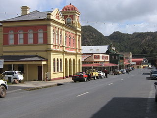
Queenstown is a town in the West Coast region of the island of Tasmania, Australia. It is in a valley on the western slopes of Mount Owen on the West Coast Range.

The Kingdom of Mutapa – sometimes referred to as the Mutapa Empire, Mwenemutapa, – was an African kingdom in Zimbabwe, which expanded to what is now modern-day Mozambique.
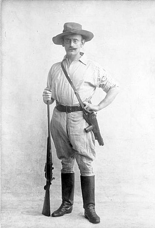
Carl Peters was a German explorer and colonial administrator. He was a major promoter of the establishment of the German colony of East Africa and one of the founders of the German East Africa Company. He was a controversial figure in Germany for his views and his brutal treatment of native Africans, which ultimately led to his dismissal from government service in 1897.

The Lost Dutchman's Gold Mine is, according to legend, a rich gold mine hidden in the Southwestern United States. The location is generally believed to be in the Superstition Mountains, near Apache Junction, east of Phoenix, Arizona. There have been many stories about how to find the mine, and each year people search for the mine. Some have died on the search.
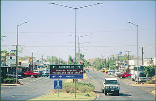
Tennant Creek is a town located in the Northern Territory of Australia. It is the seventh largest town in the Northern Territory, and is located on the Stuart Highway, just south of the intersection with the western terminus of the Barkly Highway. At the 2021 census, Tennant Creek had a population of 3,080 people, of which 55% (1,707) identified themselves as Indigenous.

The Santa Rita Mountains, located about 40 miles (64 km) southeast of Tucson, Arizona, extend 26 miles (42 km) from north to south, then trending southeast. They merge again southeastwards into the Patagonia Mountains, trending northwest by southeast. The highest point in the range, and the highest point in the Tucson area, is Mount Wrightson, with an elevation of 9,453 feet (2,881 m), The range contains Madera Canyon, one of the world's premier birding areas. The Smithsonian Institution's Fred Lawrence Whipple Observatory is located on Mount Hopkins. The range is one of the Madrean sky islands.

The George Washington and Jefferson National Forests is an administrative entity combining two U.S. National Forests into one of the largest areas of public land in the Eastern United States. The forests cover 1.8 million acres (2,800 sq mi) of land in the Appalachian Mountains of Virginia, West Virginia, and Kentucky. Approximately 1 million acres (1,600 sq mi) of the forest are remote and undeveloped and 139,461 acres (218 sq mi) have been designated as wilderness areas, which prohibits future development.

The West Coast Range is a mountain range located in the West Coast region of Tasmania, Australia.
Mount Read is a mountain located in the West Coast region of Tasmania, Australia, and is at the north west edge of the West Coast Range.
Mount Darwin is a mountain located in the West Coast region of Tasmania, Australia.

Mount Sorell is a mountain located in the West Coast region of Tasmania, Australia.

Baldy Mountain, Baldy Peak, Mount Baldy, or Old Baldy is the highest peak in the Cimarron Range, a subrange of the Sangre de Cristo Mountains of New Mexico. It is located in Colfax County, about 6 miles (10 km) northeast of Eagle Nest. It rises abruptly, with 3,640 feet (1,110 m) of vertical relief, from the Moreno Valley to the west and has a total elevation of 12,441 feet (3,792 m).
The Mount Read Volcanics is a Cambrian volcanic belt in Western Tasmania.

Sierra Buttes is an 8,591-foot-elevation (2,619-meter) mountain summit located in the Sierra Nevada mountain range in Sierra County, California, United States. It is the third-highest point in Sierra County following the north ridge of Mount Lola and Peak 8740. Sierra Buttes are set on land managed by Tahoe National Forest and are within the North Yuba River watershed. The summit is situated two miles (3.2 km) north of Sierra City, and approximately 70 miles (110 km) northeast of Sacramento. Topographic relief is significant as the southwest aspect rises nearly 4,700 feet above the Yuba–Donner Scenic Byway in approximately two miles. The prominent fortress-like landform is visible from as far as the Sacramento Valley, and inclusion on the Sierra Peaks Section peakbagging list generates climbing interest. This landform's toponym has been officially adopted by the U.S. Board on Geographic Names, and has been in use since at least 1896 when published by the Sierra Club.

Paint Bank is an unincorporated community in northern Craig County, Virginia, United States. It is located at the intersection of State Route 18 and State Route 311 northwest of the town of New Castle, the county seat. The village is located between Potts Mountain and Peters Mountain. It is one of the westernmost communities of the Roanoke metropolitan area.
Dunderberg Mountain is a 1,086-foot (331 m) mountain on the west bank of the Hudson River at the southern end of the Hudson Highlands. It lies just above Jones Point, New York, within Bear Mountain State Park and the town of Stony Point in Rockland County, New York.
Portuguese ruins in Zimbabwe are scattered across the northern parts of Zimbabwe. They are a remnant of the Portuguese colonial presence in south-eastern Africa. From their coastal settlements, the Portuguese penetrated into what is now Zimbabwe as early as 1560, nearly 300 years before David Livingstone arrived at the Victoria Falls. The most famous of these early settlers was the missionary Gonçalo da Silveira. Silveira House, a further education center outside Harare, is named after him. The Portuguese were driven out of Zimbabwe completely during 1693 when the Rozvi led by Changamire invaded Karangaland.
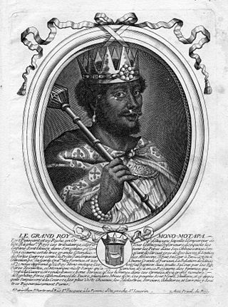
Nyatsimba Mutota was a legendary member of the royal family of Great Zimbabwe in the mid-15th century who is credited with founding the Mutapa Empire to its north, over which he reigned as its first king. Under his leadership, the Empire began a period of military conquest and expansion, which his son would go on to extend as far as the Indian Ocean.
References
- ↑ Carl Peters The Eldorado of the Ancients 1902 Page 20 "On Stanford's map of 1896 the problem seemed to be already solved; for there it was entered in Mashona- land as Mount Darwin. But if Mount Darwin was the old Mount Fura of our map, either there must be a great deal of gold in its vicinity, ...
- ↑ Carl Peters Im Goldland des Altertums - - 2014 Page 9 "Wo aber zunächst war Mount Fura, wie die Engländer ihn nannten, oder la grande montagne de Fura, wie es in meinem ... Auf Stanford's Karte vom Jahre 1899 war die Identificierung von Mount Fura und Mount Darwin bereits wieder fallen ..."
- ↑ Mutoko Madness Angus Shaw - 2013 "Israeli money brought Richard Chamberlain back for a remake of King Solomon's Mines, Rider Haggard's hero Allan Quatermain's search for legendary riches of Mount Fura, our very own Mount Darwin."
- ↑ Selous Scouts: Top Secret War- Ron Reid Daly, Peter Stiff - 1982 Page 41-"In October, four captured Z ANLA terrorists were detained in the cells at the Mount Darwin Police station ... all had been ... five kilometres outside of Mount Darwin, just at the foot of Mount Fura in the unpopulated area around Thackaray farm ..."
- ↑ The Month: An Illustrated Magazine of Literature, Science 1909 p.424 ... Silveiral that the Monomotapa's head-quarters were in the neighbourhood of Mount Fura. This mountain has been definitely identified with the present Mount Darwin, situated some [00 miles northward of Salisbury, and over 250 miles distant ..."
| | This Zimbabwe location article is a stub. You can help Wikipedia by expanding it. |