
Tenterfield is a regional town in New South Wales, Australia, situated at the junction of the New England and Bruxner highways, along the Northern Tablelands, within the New England region. At the 2016 census, Tenterfield had a population of 4,066. Tenterfield's proximity to many regional centres and its position on the route between Sydney and Brisbane led to its development as a centre for the promotion of the federation of Australia.

Mount Gambier is the second most populated city in South Australia, with an estimated urban population of 33,233 as of 2021. The city is located on the slopes of Mount Gambier, a volcano in the south east of the state, about 450 kilometres (280 mi) south-east of the capital Adelaide and just 17 kilometres (11 mi) from the Victorian border. The traditional owners of the area are the Bungandidj people. Mount Gambier is the most important settlement in the Limestone Coast region and the seat of government for both the City of Mount Gambier and the District Council of Grant.
Mount Gambier Prison is an Australian prison located in Moorak immediately south of Mount Gambier. It is managed and operated by G4S.
Penola is a town in the Australian state of South Australia located about 388 kilometres (241 mi) southeast of the state capital of Adelaide in the wine growing area known as the Coonawarra. At the 2021 Australian Census, the town of Penola had a population of 1,376.

Pomona is a rural town and locality in the Shire of Noosa, Queensland, Australia. It is about 135 kilometres north of Brisbane. The town was originally called Pinbarren Siding from 1890-1900 as a subsidiary to Pinbarren.

Tantanoola is a town in regional South Australia. The name is derived from the aboriginal word tentunola, which means boxwood / brushwood hill or camp. Tantanoola was originally named 'Lucieton' by Governor Jervois after his daughter Lucy Caroline, on 10 July 1879. It was changed by Governor Robinson to 'Tantanoola' on 4 October 1888. At the 2006 census, Tantanoola had a population of 255.

Millicent is a town in the Australian state of South Australia located about 399 kilometres (248 mi) south-east of the state capital of Adelaide and about 50 kilometres (31 mi) north of the regional centre of Mount Gambier. In the 2011 census, the population was 5,024.
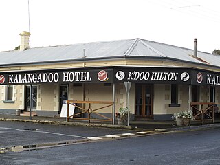
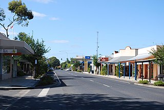
Kalangadoo, formerly Kalangadoo East, is a locality in the Australian state of South Australia located about 348 kilometres (216 mi) south-east of the state capital of Adelaide and about 31 kilometres (19 mi) north of the regional centre of Mount Gambier.
Wolseley is a small South Australian town near the Victorian border. It is five kilometres south of the Dukes Highway and 13 kilometres east of Bordertown. It was first proclaimed a town in 1884.

Ballarat railway station is located on the Serviceton line in Victoria, Australia. It serves the city of Ballarat, and opened on 11 April 1862 as Ballarat West. It was renamed Ballarat in 1865.

Mount Gambier Regional Airport is an airport in the Limestone Coast, South Australia.
Mount Burr is a small town in the south-east of South Australia, about 10 km (6.2 mi) east of Millicent and about 55 km (34 mi) north-west of Mount Gambier, in the Limestone Coast region. It derives its name from a nearby mountain, Mount Burr.

Mount Gambier, also known as Berrin, is a maar complex in South Australia associated with the Newer Volcanics Province. The complex contains four maars, the most well-known one of which is Blue Lake / Warwar. The others are Valley Lake / Ketla Malpi, Leg of Mutton Lake / Yatton Loo and Brownes Lake / Kroweratwari. The complex is partially surrounded by the city of Mount Gambier.
Glencoe is a town in South Australia, Australia, located 27 kilometres (17 mi) north-west of Mount Gambier.
Yahl is a Hamlet that is approx 7kms south east from Mount Gambier

Mount Gambier railway station was the junction station for the Naracoorte–Millicent and Mount Gambier-Heywood lines in the South Australian city of Mount Gambier. It was last used in 2006, and has since been transformed into a public community space.

Mount Schank is a locality in the Australian state of South Australia located about 385 kilometres south-east of the state capital of Adelaide and 14 kilometres south of the municipal seat of Mount Gambier in the south-east of the state.
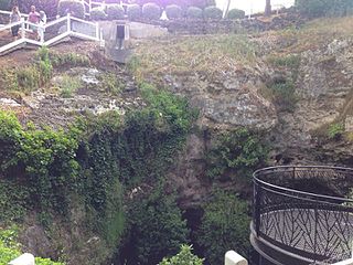
Cave Garden / Thugi, formerly known as the Cave Gardens, is a garden located in the centre of Mount Gambier, South Australia, that contains a 30 m (98 ft) deep cave. The cave was initially used as a water source for the town.
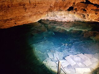
Engelbrecht Cave is a cave system in the Australian state of South Australia consisting of a sinkhole with two major passages located under the Mount Gambier urban area. It is owned by the local government area of City of Mount Gambier and has been developed as a tourism venue. Its dry extent is notable as a show cave while its water-filled extent is notable as two separate cave diving sites.
