
The Midstate Trail is a scenic footpath which runs 92 miles (148 km) through Worcester County, Massachusetts, from the Rhode Island border to the New Hampshire border, approximately 45 miles (72 km) west of Boston. The trail is considered highly accessible, scenic, and remarkably rural despite its proximity to urban Boston. The trail includes the summits of Mount Wachusett and Mount Watatic, as well as many interesting geologic, historic, and natural features.
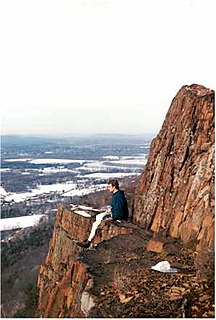
Mount Watatic is a 1,832-foot (558 m) monadnock located just south of the Massachusetts–New Hampshire border, in the United States, at the southern end of the Wapack Range of mountains. It lies within Ashburnham and Ashby, in Massachusetts, and New Ipswich, in New Hampshire; the 22 miles (35 km) Wapack Trail and the 92-mile (148 km) Midstate Trail both cross the mountain. The Yellow Arrow trail is 1.1 mile. Public parking for a half-hour hike to the summit is located on Massachusetts Route 119.

Mount Grace State Forest is a publicly owned forest with recreational features located in the town of Warwick. The state forest centers around Mount Grace, which at 1,621 feet (494 m) is the third highest point in Massachusetts east of the Connecticut River after Mount Wachusett and Mount Watatic. It is bordered by portions of Warwick State Forest to the east and west and is managed by the Massachusetts Department of Conservation and Recreation.
The Metacomet-Monadnock Trail is a 114-mile-long (183 km) hiking trail that traverses the Metacomet Ridge of the Pioneer Valley region of Massachusetts and the central uplands of Massachusetts and southern New Hampshire. Although less than 70 miles (110 km) from Boston and other large population centers, the trail is considered remarkably rural and scenic and includes many areas of unique ecologic, historic, and geologic interest. Notable features include waterfalls, dramatic cliff faces, exposed mountain summits, woodlands, swamps, lakes, river floodplain, farmland, significant historic sites, and the summits of Mount Monadnock, Mount Tom and Mount Holyoke. The Metacomet-Monadnock Trail is maintained largely through the efforts of the Berkshire Chapter of the Appalachian Mountain Club (AMC). Much of the trail is a portion of the New England National Scenic Trail.
Mount Grace, 1,617 feet (493 m), is a prominent monadnock located in north central Massachusetts in the town of Warwick, approximately two miles south of the New Hampshire border. The mountain is rugged and largely wooded, but a firetower on the summit provides expansive views of the surrounding rural countryside. Little Mount Grace, 1,226 feet (374 m), is the southern summit of the mountain. Mount Grace supports a predominantly northern hardwood forest as well as stands of red spruce near its summit.
Founded in Worcester, Massachusetts in 1987, the Greater Worcester Land Trust is a non-profit land conservation organization dedicated to the protection of important lands in Worcester and the surrounding towns. As a conservation land trust the trust's properties are managed simultaneously for wildlife habitat and passive recreation
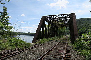
Mount Tom is a village in the city of Easthampton, Massachusetts, in the United States. It is located in a narrow strip of land between Mount Tom to the south, the Connecticut River to the east, and The Oxbow, an old channel of the Connecticut River, to the north. Interstate 91, U.S. Route 5, and Pan Am Railways' tracks all pass through the village's vicinity as they follow the Connecticut River.

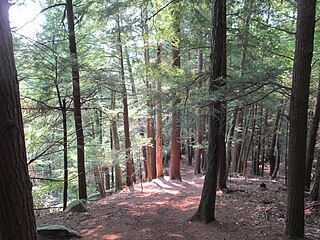
The Brooks Woodland Preserve is a 558-acre (226 ha) open space preserve located in Petersham, Massachusetts. The property, named after industrialist and dipolomat James Willson Brooks, is managed by the land conservation non-profit organization The Trustees of Reservations and offers 13 miles (21 km) of trails and primitive woods roads available for hiking, horseback riding, and cross country skiing. Second growth forest, overgrown farm fields, granite ledges, historic stone walls, creeks, and rolling hills characterize the preserve.

The Wapack Wilderness is a 1,400-acre (6 km2) tract of forest in the towns of Rindge and New Ipswich, New Hampshire. The land is owned by the Hampshire Country School, a small, private school for students who do not thrive in traditional settings. It abuts Binney Pond Natural Area and land conserved by the New England Forestry Foundation. Watatic Mountain Wildlife Area is two miles (3 km) to the southeast, and Annett State Forest is two miles (3 km) to the northeast. The headwaters of the Millers River flow from the area, feeding into Converse Meadows and Lake Monomonac before entering Massachusetts.

The Robert Frost Trail is a 47-mile (76 km) long footpath that passes through the eastern Connecticut River Valley of Massachusetts. The trail runs from the Connecticut River in South Hadley, Massachusetts to Ruggles Pond in Wendell State Forest, through both Hampshire and Franklin County and includes a number of scenic features such as the Holyoke Range, Mount Orient, Puffer's Pond, and Mount Toby. The trail is named after the poet Robert Frost, who lived and taught in the area from 1916 to 1938.
The Tully Trail is a 22-mile (35 km) scenic loop trail located in the towns of Royalston, Orange, and Warwick, Massachusetts near the New Hampshire border. The route crosses several ledges with sweeping views of the surrounding rural countryside and passes three waterfalls. Tully Mountain, Jacobs Hill, and Tully Lake are also located on the trail. The Tully Trail coincides briefly with the 110-mile (180 km) Metacomet-Monadnock Trail. The route follows a mostly protected corridor of state, federal, and non-profit owned land.

Royalston Falls is a 50 foot (15 m) waterfall and granite gorge located in Royalston, Massachusetts along Falls Brook, a tributary of the Tully River which in turn is a tributary of the Millers River. The falls are part of a 217-acre (88 ha) open space preserve acquired in 1951 by the land conservation non-profit organization The Trustees of Reservations. The 22-mile (35 km) Tully Trail and the 110-mile (180 km) Metacomet-Monadnock Trail, a National Recreation Trail, pass through the property.

The Oxbow is an extension of the Connecticut River, located in Northampton, Massachusetts. It is well-known for its appearance in the 1836 painting The Oxbow by Thomas Cole.

Elliott Laurel is a 33-acre (13 ha) open space preserve located in Phillipston, Massachusetts. The property, notable for its extensive stands of mountain laurel, is managed by the land conservation non-profit organization The Trustees of Reservations. Elliott Laurel also contains woodlands, ledges, boulders, and a hayfield.
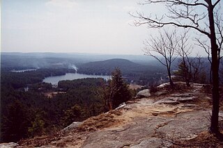
Jacobs Hill is a 173-acre (70 ha) open space preserve in Royalston, Massachusetts acquired in 1975 by the land conservation non-profit organization The Trustees of Reservations. The preserve includes scenic vistas, ledges, woodlands, a northern bog, and Spirit Falls, a 30 foot (9.1 m) waterfall. The 22-mile (35 km) Tully Trail passes through the property. Views from the ledges include the Berkshires as well as nearby Long Pond and the Tully River Valley, Tully Mountain, and Mount Grace.

North Common Meadow is a 25-acre (10 ha) open space preserve in the town of Petersham, Massachusetts. The property, part of a larger, contiguous area of protected open space including Harvard Forest and The Trustees of Reservations' Brooks Woodland Preserve, is maintained as grassland in keeping with the town's rural character.

The Swift River Reservation is a 439-acre (178 ha) open space preserve located in Petersham, Massachusetts, United States. The property, named after the East Branch of the Swift River, is managed by the land conservation non-profit organization The Trustees of Reservations and offers 7 miles (11 km) of trails available for hiking, horseback riding, mountain biking, and cross country skiing. Ledges, river corridor, woodlands, scenic vistas, and wetlands characterize the preserve.

Tully Lake, of Royalston, Massachusetts, is a 1,262-acre (511 ha) reservoir and flood control project constructed by the United States Army Corps of Engineers (USACE) in 1949 for 1.6 million dollars. The project prevents flooding of the greater Connecticut River and Millers River valleys and provides a variety of recreational opportunities, including a campground operated by The Trustees of Reservations. Tully Lake is an important link in the 22-mile (35 km) Tully Trail.

Fairhaven Bay is a lake located within the Sudbury river in Concord, Massachusetts, United States (US). It was frequented by Henry David Thoreau who, together with Edward Hoar, accidentally set fire to the woods near the bay in April 1844, as later described in Thoreau's journal.
Land of Providence is a 25-acre (100,000 m2) open space reservation located in the Ingleside neighborhood of Holyoke, Massachusetts, on the banks of the Connecticut River. The property was previously owned by the Sisters of Providence. In 2009 it was donated to The Trustees of Reservations and is now used for farming by the local organization Nuestras Raices, which allows local residents farm the land and raise livestock.

