Related Research Articles
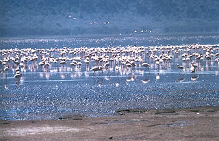
The Rift Valley lakes are a series of lakes in the East African Rift valley that runs through eastern Africa from Ethiopia in the north to Malawi in the south, and includes the African Great Lakes in the south. These include some of the world's oldest lakes, deepest lakes, largest lakes by area, and largest lakes by volume. Many are freshwater ecoregions of great biodiversity, while others are alkaline "soda lakes" supporting highly specialised organisms.
Metemma, also known as Metemma Yohannes, is a town in northwestern Ethiopia, on the border with Sudan. Located in the Semien Gondar Zone of the Amhara Region, Metemma has a latitude and longitude of 12°58′N36°12′E with an elevation of 685 meters above sea level. Across the border is the corresponding Sudanese village of Gallabat. According to the British diplomat Hormuzd Rassam, who travelled through Metemma in November 1865 on his diplomatic mission to Emperor Tewodros II, "Metemma" comes from the Arabic word for "the place of cutting, or termination – indicating the end of the Muslim provinces", although at the time the settlement was better known as Suk ul-Gallabat.

Turmi is a market town in south-western Ethiopia. Located in the Debub Omo Zone of the South Ethiopia Regional State, the town has a latitude and longitude of 4°58′N36°29′E with an elevation of 925 metres above sea level.

Asella is a town in central Ethiopia. Located in the Arsi Zone of the Oromia Region 126 km (78 mi) south from Addis Ababa, this town has a latitude and longitude of 7°57′N39°7′E, with an elevation of 2,430 meters. Asella hosts an Asella Airport. Asalla was the capital of Arsi Province until that province was demoted to a Zone of Oromia with the adoption of the 1995 Constitution. It retains some administrative functions as the seat of the present Arsi Zone.
Bolo is a town in central Ethiopia. Located in the Semien Shewa Zone of the Amhara Region, it has a latitude and longitude of 8°50′N39°22′E with an elevation of 1891 meters above sea level.

Omorate is a town in southern Ethiopia near the Kenyan border. Located in the Debub Omo Zone of the Southern Nations, Nationalities and Peoples' Region, this village has a latitude and longitude of 4°48′N35°58′E with an elevation of 395 meters above sea level. It is the administrative center of Kuraz woreda.

Dogu'a Tembien is a woreda in Tigray Region, Ethiopia. It is named in part after the former province of Tembien. Nowadays, the mountainous district is part of the Southeastern Tigray Zone. The administrative centre of this woreda is Hagere Selam.
Guradamole is one of the woredas in the Somali Region of Ethiopia. Part of Guradamole is bounded on the south by the Ganale Dorya River which separates it from the Liben Zone, on the west by Kersa Dula, on the north by the Oromia Region, and on the east by Goro Bekeksa. Towns in this woreda include Haro Dibe and Qundi.
Hawzen is a town in northern Ethiopia. Located in the Misraqawi (Eastern) Zone of the Tigray Region, this town has a latitude and longitude of 13°58′N39°26′E with an elevation of 2105 meters above sea level. Its market day is Wednesday. It is the largest settlement in Hawzen woreda.

Waliso is a town in Southwest Shewa Zone of the Oromia Region in Ethiopia, 114 km southwest of Addis Ababa, it has a latitude and longitude of 8°32′N37°58′E with an elevation of 2063 meters above sea level. Waliso is the administrative center of this Zone.
Werder is a town in eastern Ethiopia. Located in the Werder Zone of the Somali Region, Werder has a latitude and longitude of 6°58′N45°21′E with an elevation of 541 meters above sea level. It is the administrative center of Werder woreda.
Wenji Gefersa a town in central Ethiopia. Located in the East Shewa Zone of the Oromia, it has a latitude and longitude of 8°27′N39°17′E with an elevation of 1588 meters above sea level.

Boditi, or is a city in south central Ethiopia. Located in the Wolaita Zone of the South Ethiopia Regional State, this town has a latitude and longitude of 6°58′N37°52′E with an average elevation of 2050 meters above sea level. It is the administrative center of Damot Gale woreda. The town is bounded by Shasha-Gale Kebele in the north, Ade-Koisha Kebele in the south, Chawkare Kebele in the east and Sibaye-Korke kebele in the west. It is located in East Rift valley at a distance of 180 mi (290 km) to the south of Addis Ababa and at about 86 mi (138 km) to the west of Hawassa.

Mojo is a town in central Ethiopia, named after the nearby Modjo River. Located in the East Shewa Zone of the Oromia Region, it has a latitude and longitude of 8°39′N39°5′E with an elevation between 1788 and 1825 meters above sea level. It is the administrative center of Lome district.
Asasa is a town in southeastern Ethiopia. Located in the West Arsi Zone of the Oromia Region, this town has a latitude and longitude of 07°06′N39°12′E with an elevation of 2367 meters above sea level. It is the administrative center of Gedeb Asasa woreda.
Kula is a town in southeastern Ethiopia. Located in the Arsi Zone of the Oromia Region, it has a latitude and longitude of 07°58′N39°42′E with an elevation of 2842 meters above sea level. The town is the administrative center of Sude woreda; according to materials on the Nordic Africa Institute website, it had been the administrative center at least as early as the 1980s.
Sela Dingay is a town in central Ethiopia. In Amharic the name means the sharpened stone, named for a rock which rolled over the edge of the southern rim of the gorge of the Mofar River, and killed a group of people sitting on it. Located in the Semien Shewa Zone of the Amhara Region, this town has a latitude and longitude of 09°58′N39°38′E with elevations variously given as 2880 and 2915 meters above sea level. It is the administrative center of Mojana Wadera woreda.
Guder is a town located in the West Shewa Zone of the Oromia of Ethiopia. Located 12km west of Ambo, this town has a latitude and longitude of 8°58′N37°46′E, with an elevation of 2101 meters above sea level. Guder is famous for its Guder River Falls and year-round fruit production, using plentiful water resources in the vicinity.
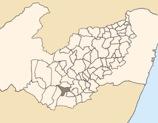
Saloá is a city in the state of Pernambuco, Brazil. It is 263 km away from the state capital Recife, and has an estimated population of 15,862 inhabitants.
Samre is a town in northern Ethiopia. Located in the Debub Misraqawi (south-eastern) Zone of the Tigray Region, this town has a latitude and longitude of 13°11′N39°12′E with an elevation of 1855 meters above sea level. It is one of two towns in Saharti Samre woreda.
References
- ↑ Elevation per Ethiopian Mapping Authority. 2010 National Statistics (Abstract): climate, Table A.1. Central Statistical Agency website (accessed 18 March 2011)
| | This article about a location in the Oromia Region of Ethiopia is a stub. You can help Wikipedia by expanding it. |