Related Research Articles

Sahand, is a massive, heavily eroded stratovolcano in East Azerbaijan Province, northwestern Iran. At 3,707 m (12,162 ft), it is the highest mountain in the province of East Azarbaijan.
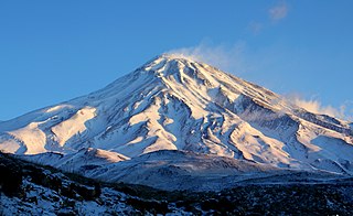
Mount Damavand is a potentially active stratovolcano, the highest peak in Iran and Western Asia and the highest volcano in Asia and the 2nd highest volcano in the Eastern Hemisphere, at an elevation of 5,671 metres (18,606 ft). Damāvand has a special place in Persian mythology and folklore. It is in the middle of the Alborz range, adjacent to Varārū, Sesang, Gol-e Zard, and Mīānrūd. It is near the southern coast of the Caspian Sea, in Amol County, Mazandaran Province, 66 km (41 mi) northeast of the city of Tehran.

The Karkas mountain chain is a mountain range which is located almost in central Iran. Having a northwest-southeast direction, it is stretched from Kashan to Ardestan for more than 100 kilometres. With an elevation of 3895 metres, the highest peak of the Karkas Mountains is Mount Karkas which is situated close to Natanz.

Bazman is a dormant stratovolcano in a remote desert region of Sistan and Baluchestan Province in south-eastern Iran. A 500-m-wide crater caps the summit of the dominantly andesitic-dacitic volcano, the flanks of which are covered by monogenetic centres especially to the northwest. Bazman is a geologically young volcano which formed mainly in the Quaternary, with the oldest dated rocks being 11.7 million years old and the youngest 0.6 million years. Although no historic eruptions have been reported from Bazman, it does contain fumaroles. Thus Bazman may be regarded as dormant, rather than extinct. Its satellite cones have been the source of basaltic lava flows.
Shir Kuh or Shirkuh is a high peak in the central part of Iran about 40 km (25 mi) south-west of the city of Yazd in Yazd Province. The first woman to climb the mountain was Banoo Khosrawy.

Taftan is an active stratovolcano in south-eastern Iran in the Sistan and Baluchestan province. With variable heights reported, all around 4,000 metres (13,000 ft) above sea level, it is the highest mountain in south-eastern Iran. The nearest city is Khash.

Kandovan is an ancient village in Sahand Rural District in the Central District of Osku County, East Azerbaijan Province, northwestern Iran. It is situated in the foothills of Mount Sahand, near the city of Osku. At the 2006 census, the village population was 601, in 168 families.

Yamsay Mountain is a large shield volcano in the Cascade Range of south-central Oregon, located about 35 miles (56 km) east of Crater Lake on the border between Klamath County and Lake County. It is part of the Cascade Volcanic Arc but is located in a mountain range 30 to 50 miles behind the main Cascade volcanic front. The best known members of this enigmatic arc are the massive shields of Newberry Volcano, about 55 miles (89 km) farther north in Oregon, and Medicine Lake Volcano, about 80 miles (130 km) south in Northern California. Yamsay is the highest volcano in the eastern arc, almost 300 feet (90 m) higher than Newberry and Medicine Lake.
The Jebal Barez is a mountain chain in the Kerman Province of Iran. This mountain range stretches for some 100 km north-west to south-east, parallel to the Halil Rud, to the north-east of Jiroft and to the south-west of Bam, rising to a maximal elevation of 3,750 m. The mountains of this range are continued by other mountains such as Mount Shahsavaran and Mount Hudian to the south-east. They separate the plain of Hamun-e Jaz Murian from that of Namakzar-e Shahdad and Lut desert.
Hazaran is the name of a massif of the Central Iranian Plateau, Kerman Province, Iran, an eastern outlier of the Zagros Mountains. With an elevation of 4500 metres, it is the highest peak in Kerman Province. The jebal Barez chain is a continuation to the south-east. The Halil River rises in the Bid Khan region. The massif is situated in the area encircled by the cities of Kerman, Bardsir, Sirjan, Baft, Jiroft and Bam.

The Alborz range, also spelled as Alburz, Elburz or Elborz, is a mountain range in northern Iran that stretches from the border of Azerbaijan along the western and entire southern coast of the Caspian Sea and finally runs northeast and merges into the smaller Aladagh Mountains and borders in the northeast on the parallel mountain ridge Kopet Dag in the northern parts of Khorasan. All these mountains are part of the much larger Alpide belt. This mountain range is divided into the Western, Central, and Eastern Alborz Mountains. The Western Alborz Range runs south-southeastward almost along the western coast of the Caspian Sea. The Central Alborz runs from west to east along the entire southern coast of the Caspian Sea, while the Eastern Alborz Range runs in a northeasterly direction, toward the northern parts of the Khorasan region, southeast of the Caspian Sea. Mount Damavand, the highest mountain in Iran measuring 5,610.0 m, is located in the Central Alborz Mountains.

Sahand is a Moudge-class frigate in the Southern Fleet of the Islamic Republic of Iran Navy, named in memory of the sunk frigate bearing the same name after Sahand volcano.
The Binalud Mountain Range or the Binalud Range is a mountain range that runs in a northwest-southeast direction between the Nishapur and Mashhad regions in Razavi Khorasan Province in northeastern Iran, to the southeast of the Caspian Sea. Although far from the Aladagh Mountains, which lie to the northwest in the Province of North Khorasan, the Binalud Mountains are located in such a way that both the Aladagh Mountains and the Binalud Range lie approximately in the same arc, curving from the northwest to the southeast. The city of Mashhad or Meshed is located in the northeastern part of the Binalud Range, and the city of Nishapur or Neyshabur lies on the southwestern section of the range. Situated somewhat to the west of the Binalud Range proper, and with an elevation of 3211 metres, Mount Binalud is the highest point both of the Binalud Mountains and of Razavi Khorasan Province as a whole.

The main points that are discussed in the geology of Iran include the study of the geological and structural units or zones; stratigraphy; magmatism and igneous rocks; ophiolite series and ultramafic rocks; and orogenic events in Iran.
Mount Marshenan or Mount Mareshnan is a mountain that is located approximately 60 kilometres north-east of the city of Isfahan and 30 kilometres north of Kuhpayeh. With an elevation of 3330 metres, this mountain is about 15 kilometres south-east of Zefreh and 3 kilometres south of the village of Marshenan in Isfahan Province, almost in central Iran. Made chiefly of Eocene andesite and pyroclastic rocks, Mount Marshenan is situated in a central Iranian range, Sahand-Bazman volcanic range or belt, a mountain range which was formed mainly during Eocene volcanism and that stretches approximately from Sahand volcano in the north-west of Iran to Bazman volcano in the south-east of Iran.
Mount Bahr Aseman is a mountain that is located approximately 15 kilometres south of the town of Sarduiyeh and about 60 kilometres east of the city of Baft in Kerman Province. With an elevation of 3886 metres, this mountain is among high peaks of Iran. Made chiefly of Eocene pyroclastic rocks, Mount Bahr Aseman is situated in a central Iranian range, Sahand-Bazman volcanic range or belt, a mountain range which was formed mainly during Eocene volcanism and that stretches approximately from Sahand Volcano in the north-west of Iran to Bazman Volcano in the south-east of Iran.
Qaflankuh or Qaflankuh Mountain Range is a mountain range that is located about 20 kilometres north of the city of Zanjan in Zanjan Province, Iran. With an average width of almost 20 kilometres and a length of about 100 kilometres, this mountain range is stretched in a northwest–southeast direction, beginning from northwest of Zanjan, passing north of Zanjan and ending southeast of Zanjan. The Qezel Owzan River flows in a valley that separates Qaflankuh Mountains on the south from Talish Mountains on the north. With an elevation of 2971 metres, Mount Sendan Dagh is the highest mountain of the range which is located in the southeast section of this mountain range. There are some mineral hot springs containing sulphur in different parts of this range. Geologically, Qaflankuh Mountain Range was formed during the Tertiary volcanism and plutonism and is made mainly of the Eocene volcanic rocks with very small sections of intrusive rocks in the northern and southern parts of the range.
The Sahand-Bazman Volcanic and Plutonic Belt or the Sahand-Bazman Igneous Arc or the Central Iranian Range is a mountain range that is made by igneous and pyroclastic rocks. Located East and almost parallel to the Zagros Mountains, the Central Iranian Range is stretched in a north-west-southeast direction from Mount Sahand in Azerbaijan in the north-west to Mount Bazman in Baluchistan in the Southeastern part of Iran. This range was mainly formed during the Tertiary volcanic and orogenic phase and especially in the Eocene volcanism and plutonism. The Central Iranian Range or the Sahand-Bazman Volcanic Belt includes famous mountains such as the Sahand in East Azerbaijan Province, Mount Karkas in the Karkas Mountains and Mount Marshenan in Isfahan Province, the Jebal Barez, Mount Hezar and Mount Lalehzar in Kerman Province, and the Bazman in the Sistan va Baluchestan Province of Iran.
Shahsavaran is a volcanic field in Iran. It covers an ellipse shaped area west of Bazman volcano. The field has erupted lava cones and lava flows, along with some explosive volcanic activity especially in the eastern part of the field. Volcanic rocks in the field are dominated by andesite, with subordinate basalt, dacite and rhyodacite. The volcanism has lasted from 12 million years ago to recent times, the 2010 Hosseinabad earthquake took place within the field but seems to be unrelated to volcanic activity.
References
- ↑ Microsoft Encarta World Atlas, 2001, Microsoft Corporation
- ↑ Geological Map of Iran, National Geoscience Database of Iran, www.ngdir.ir