Related Research Articles
The Ruahine Range is the largest of several mountain ranges in the North Island of New Zealand that form a ridge running parallel with the east coast of the island between East Cape and Wellington. The ridge is at its most pronounced from the central North Island down to Wellington, where it comprises the Ruahine, Tararua and Remutaka Ranges.

The Manawatū River is a major river of the lower North Island of New Zealand. The river flows from the Ruahine Ranges, through both the Manawatū Gorge and the city of Palmerston North, and across the Manawatū Plains to the Tasman Sea at Foxton.

Pahia is a small rural locality in coastal Southland, New Zealand, not to be confused with the North Island tourist resort of Paihia. Surrounding areas include Ruahine, Wakapatu, Round Hill, Colac Bay and Orepuki. The main road, Orepuki-Riverton Hwy, runs through it. Pahia is 15 minutes from Riverton, 20 minutes from Tuatapere and 45 minutes from Invercargill.
The Waipawa River is a braided river of southern Hawke's Bay, in New Zealand's eastern North Island. It flows southeast from the slopes of 1,687 m (5,535 ft) Te Atuaoparapara in the Ruahine Range, past the town of Waipawa, before joining the Tukituki River. The river rises at the 1,326 m (4,350 ft) Waipawa Saddle, which is also the source of the Waikamaka River. The Mangaonuku Stream is a tributary on the northern bank, west of Waipawa, near Ruataniwha. The Waipawa's flow is generally greater than that of the Tukituki River, into which it flows.
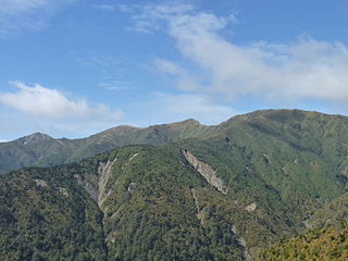
Te Atua Mahuru is a prominent peak in southern Hawke's Bay, in New Zealand's eastern North Island. It lies in the Ruahine Range, within the boundaries of the Ruahine Forest Park, of which it is the second highest peak, at 1534 metres. The Makaroro River has its source on the eastern flanks of Te Atua Mahuru. The slightly smaller Mount Maropea lies just to the south.
Te Rehunga is a rural locality located in the Tararua District, part of the Manawatū-Whanganui Region of New Zealand.
Ruahine is a former New Zealand parliamentary electorate, from 1972 to 1978.
The Makaretu River is a river of the southern Hawke's Bay region of New Zealand's North Island. One of numerous roughly parallel rivers, it flows east from the slopes of the Ruahine Range north of Dannevirke, passing close to the township of Takapau before meeting the waters of the Tukituki River just to the west of Waipukurau.
The Makaroro River is a river of the southern Hawke's Bay region of New Zealand's North Island. It flows southeast from the slopes of the Ruahine Range, meeting the waters of the Waipawa River 12 kilometres (7 mi) west of Tikokino.
The Mangatera River is a river of the Manawatū-Whanganui region of New Zealand's North Island. It flows northwest from its origins in the Ruahine Range to reach the Rangitīkei River 25 kilometres (16 mi) east of Taihape.
The Mangatewai River is a river of the Hawke's Bay Region of New Zealand's North Island. It flows generally east from the Ruahine Range to reach the Tukipo River 5 kilometres (3 mi) north of the township of Takapau.
The Mangatewainui River is a river of the Manawatū-Whanganui region of New Zealand's North Island. An upper tributary of the Manawatu River, it flows generally southeast from its sources in the Ruahine Range northwest of Norsewood, and meets the young Manawatu River 8 kilometres (5 mi) east of Dannevirke.
The Mangawharariki River is a river of the Manawatū-Whanganui region of New Zealand's North Island. It flows northwest from the Ruahine Range to meet the Rangitikei River at Mangaweka.
The Maropea River is a river of the Manawatū-Whanganui region of New Zealand's North Island. It flows northwest from the Ruahine Range to join the Whakaurekou River 25 kilometres (16 mi) east of Taihape.
The Tukipo River is a river of the southwest Hawke's Bay region of New Zealand's North Island. It flows east from its origins in the Ruahine Range to reach the Tukituki River five kilometres west of Waipukurau
The Waikamaka River is a river of the Manawatū-Whanganui region of New Zealand's North Island. It is a tributary of the Whakaurekou River, part of the Rangitikei River system. The Waikamaka flows northwest from its sources in the Ruahine Range to reach the Whakaurekou 15 kilometres (9 mi) east of Taihape.
The Whakaurekou River is a river of the Manawatū-Whanganui region of New Zealand's North Island. It flows northwest from its origins in the Ruahine Range to reach the Rangitikei River 25 kilometres (16 mi) east of Taihape.
Ashley Clinton is a rural community in the Central Hawke's Bay District and Hawke's Bay Region of New Zealand's North Island.

Āpiti is a small township in the North Island of New Zealand. It is located to the northeast of the small town of Kimbolton in the Manawatū-Whanganui region. It is located on a small plain, the Apiti Flats, close to the valley and gorge of the Oroua River, near Rangiwahia and close to the foot of the Ruahine Range.

Central Hawke's Bay District Council is the territorial authority for the Central Hawke's Bay District of New Zealand. It consists of the mayor of Central Hawke's Bay, and eight councillors. The current mayor is Alex Walker.
References
39°44′40″S176°10′36″E / 39.744546°S 176.176621°E
| | This Hawke's Bay Region geography article is a stub. You can help Wikipedia by expanding it. |