Related Research Articles
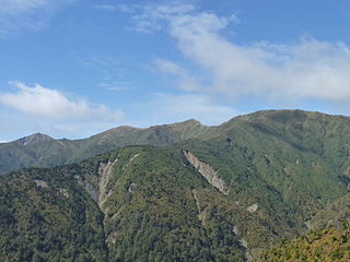
The Ruahine Range is the largest of several mountain ranges in the North Island of New Zealand that form a ridge running parallel with the east coast of the island between East Cape and Wellington. The ridge is at its most pronounced from the central North Island down to Wellington, where it comprises the Ruahine, Tararua and Remutaka Ranges.
The Scott Mountains are a large number of isolated peaks lying south of Amundsen Bay in Enderby Land of East Antarctica, Antarctica. Discovered on 13 January 1930 by the British Australian New Zealand Antarctic Research Expedition (BANZARE) under Sir Douglas Mawson. He named the feature Scott Range after Captain Robert Falcon Scott, Royal Navy. The term mountains is considered more appropriate because of the isolation of its individual features.

Pahia is a small rural locality in coastal Southland, New Zealand, not to be confused with the North Island tourist resort of Paihia. Surrounding areas include Ruahine, Wakapatu, Round Hill, Colac Bay and Orepuki. The main road, Orepuki-Riverton Hwy, runs through it. Pahia is 15 minutes from Riverton, 20 minutes from Tuatapere and 45 minutes from Invercargill.
Athos Range is the northernmost range in the Prince Charles Mountains of Mac. Robertson Land, Antarctica. The range consists of many individual mountains and nunataks that trend east–west for 40 miles (64 km) along the north side of Scylla Glacier.
Te Pōhue is a small settlement in inland Hawke's Bay, in New Zealand's eastern North Island. It lies on State Highway 5, 31 kilometres inland from Whirinaki.
The Waipawa River is a braided river of southern Hawke's Bay, in New Zealand's eastern North Island. It flows southeast from the slopes of 1,687 m (5,535 ft) Te Atuaoparapara in the Ruahine Range, past the town of Waipawa, before joining the Tukituki River. The river rises at the 1,326 m (4,350 ft) Waipawa Saddle, which is also the source of the Waikamaka River. The Mangaonuku Stream is a tributary on the northern bank, west of Waipawa, near Ruataniwha. The Waipawa's flow is generally greater than that of the Tukituki River, into which it flows.
Taraponui is a prominent peak in inland Hawke's Bay, in New Zealand's eastern North Island. It lies between the settlements of Te haroto and Tutira and rises to a height of 1308 meters. It is most noticed by a sharp drop on the west side and a large radio tower on top.
Mount Maropea is a prominent peak in southern Hawke's Bay, in New Zealand's eastern North Island, rising to 1481 metres. It lies in the Ruahine Range, within the boundaries of the Ruahine Forest Park. The slightly larger Te Atua Mahuru lies just to the north.

Rangitāne is a Māori iwi (tribe). Their rohe (territory) is in the Manawatū, Horowhenua, Wairarapa and Marlborough areas of New Zealand.
Te Rehunga is a rural locality located in the Tararua District, part of the Manawatū-Whanganui Region of New Zealand.
The Makaroro River is a river of the southern Hawke's Bay region of New Zealand's North Island. It flows southeast from the slopes of the Ruahine Range, meeting the waters of the Waipawa River 12 kilometres (7 mi) west of Tikokino.
The Mangatera River is a river of the Manawatū-Whanganui region of New Zealand's North Island. It flows northwest from its origins in the Ruahine Range to reach the Rangitīkei River 25 kilometres (16 mi) east of Taihape.
The Mangatewai River is a river of the Hawke's Bay Region of New Zealand's North Island. It flows generally east from the Ruahine Range to reach the Tukipo River 5 kilometres (3 mi) north of the township of Takapau.
The Mangatewainui River is a river of the Manawatū-Whanganui region of New Zealand's North Island. An upper tributary of the Manawatu River, it flows generally southeast from its sources in the Ruahine Range northwest of Norsewood, and meets the young Manawatu River 8 kilometres (5 mi) east of Dannevirke.
The Maropea River is a river of the Manawatū-Whanganui region of New Zealand's North Island. It flows northwest from the Ruahine Range to join the Whakaurekou River 25 kilometres (16 mi) east of Taihape.
The Tukipo River is a river of the southwest Hawke's Bay region of New Zealand's North Island. It flows east from its origins in the Ruahine Range to reach the Tukituki River five kilometres west of Waipukurau
The Whakaurekou River is a river of the Manawatū-Whanganui region of New Zealand's North Island. It flows northwest from its origins in the Ruahine Range to reach the Rangitikei River 25 kilometres (16 mi) east of Taihape.
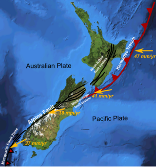
The North Island Fault System (NIFS) is a set of southwest–northeast trending seismically-active faults in the North Island of New Zealand that carry much of the dextral strike-slip component of the oblique convergence of the Pacific Plate with the Australian Plate. However despite at least 3 km (1.9 mi) of uplift of the axial ranges in the middle regions of the fault system during the last 10 million years most of the shortening on this part of the Hikurangi Margin is accommodated by subduction.
The Grosvenor Mountains are a group of widely scattered mountains and nunataks rising above the Antarctic polar plateau east of the head of Mill Glacier, extending from Mount Pratt in the north to the Mount Raymond area in the south, and from Otway Massif in the northwest to Larkman Nunatak in the southeast.

Central Hawke's Bay District Council is the territorial authority for the Central Hawke's Bay District of New Zealand. It consists of the mayor of Central Hawke's Bay, and eight councillors. The current mayor is Alex Walker.
References
39°43′S176°11′E / 39.717°S 176.183°E
| | This Hawke's Bay Region geography article is a stub. You can help Wikipedia by expanding it. |