Tottori Prefecture is a prefecture of Japan located in the Chūgoku region of Honshu. Tottori Prefecture is the least populous prefecture of Japan at 570,569 (2016) and has a geographic area of 3,507 km2. Tottori Prefecture borders Shimane Prefecture to the west, Hiroshima Prefecture to the southwest, Okayama Prefecture to the south, and Hyogo Prefecture to the east.

Kawanishi is a city in Hyōgo Prefecture (兵庫県) in the northwestern part of the Kansai region of Japan, about 5 km north of Osaka Itami Airport. It is bordered on the west by the Inagawa river.
Asago was a town located in Asago District, Hyōgo Prefecture, Japan. The town was founded on March 31, 1954 from the merger of the former villages of Yamaguchi and Nakagawa.

Mount Ibuki is a 1,377-metre-high (4,518 ft) mountain, on the border of Maibara, Shiga Prefecture, and Ibigawa, Gifu Prefecture, Japan. It is one of the 100 Famous Japanese Mountains, and is also included on the lists of the 100 Kinki Mountains and the 50 Shiga Mountains. Mount Ibuki is the highest mountain in Shiga Prefecture.

Maniwa is a city located in north-central Okayama Prefecture, Japan. Its northernmost border meets that of Tottori Prefecture.

Mount Daisen, is a volcanic mountain in Tottori Prefecture, Japan. It has an elevation of 1,729 metres. This mountain is the highest in the Chūgoku region, and the most important volcano on the Daisen volcanic belt: a part of Southwest Honshu volcanic arc, where the Philippine Sea Plate is subducting under the Amurian Plate.

Mount Ōfuna is a 653.1 metre high Japanese mountain in Sanda, Hyōgo, Japan.

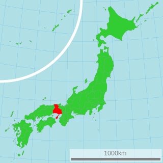
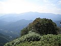
Mount Hyōno is a mountain on the border of Yabu, Hyōgo Prefecture, and Wakasa, Tottori Prefecture, in Japan. It is the highest mountain in Hyōgo Prefecture. This mountain is one of the 200 famous mountains in Japan. Other names of this mountain are Suga-no-sen, Hyō-zan, Hyō-no-yama, Kōri-no-yama.

Mount Ushiro is a mountain on the border of Shisō, Hyōgo Prefecture, and Mimasaka, Okayama Prefecture, Japan. It is the highest mountain in Okayama Prefecture and the third highest mountain in Hyōgo Prefecture, after Mount Hyōno and Mount Mimuro. In Hyōgo Prefecture this mountain is also known as Itabami-san and in Tottori Prefecture it is also known as Ushiro-no-sen.

Mount Seppiko is a mountain or mountains in Himeji, Hyōgo, Japan. This mountain is one of the San-hiko-san, three Hiko Shugendō mountains in Japan, and also one of Hyōgo 50 mountains, and Kinki 100 mountains. It forms part of Seppiko-Mineyama Prefectural Natural Park.

Mount Haku is a mountain in Nishiwaki, Hyōgo Prefecture, Japan. This mountain is one of the Hyōgo 50 Mountains.

Mount Nagi, is a mountain located on the border of Chizu, Tottori Prefecture, and Nagi, Okayama Prefecture, Japan. The other reading of this mountain's kanji is Nagisen.

Mount Myōken is a 1,135.5 m (3,725 ft) mountain on the border of Yabu and Kami, Mikata, Hyogo, Japan. This mountain is one of Hyōgo 50, and a part of Hyonosen-Ushiroyama-Nagisan Quasi-National Park. The other name of this mountain is Mount Ishihara.

Mount Sen is a 1,005.2 m (3,298 ft) mountain of Chūgoku Mountains, located on the border of Taka and Kamikawa, Hyōgo, Japan. This mountain is one of Hyōgo 50 mountains. This mountain is an important center of Kasagatayama-Sengamine Prefectural Natural Park.

Mount Kasagata is a 939.4 m (3,082 ft) mountain in the Chūgoku Mountains, located on the border of Taka and Kamikawa, Hyōgo, Japan. This mountain is one of Hyōgo 50 mountains. This mountain is an important center of Kasagatayama-Sengamine Prefectural Natural Park.

The Harima Expressway is a national expressway in Hyōgo Prefecture, Japan. It is owned and operated by West Nippon Expressway Company. It is signed as E29 under the Ministry of Land, Infrastructure, Transport and Tourism's "2016 Proposal for Realization of Expressway Numbering."

The Tottori Expressway is an expressway connecting Sayō in Hyōgo Prefecture and Tottori, the capital and largest city in Tottori Prefecture. It is owned and operated by partly by the West Nippon Expressway Company and the Ministry of Land, Infrastructure, Transport and Tourism. The expressway is signed as an auxiliary route of National Route 373 as well as E29 under the Ministry of Land, Infrastructure, Transport and Tourism's "2016 Proposal for Realization of Expressway Numbering."