The Canadian Rockies or Canadian Rocky Mountains comprise the Canadian segment of the North American Rocky Mountains. They are the eastern part of the Canadian Cordillera, which is a system of multiple ranges of mountains which runs from the Canadian Prairies to the Pacific Coast. The Canadian Rockies mountain system comprises the southeastern part of this system, lying between the Interior Plains of Alberta and Northeastern British Columbia on the east to the Rocky Mountain Trench of BC on the west. The southern end borders Idaho and Montana of the United States. In geographic terms the boundary is at the Canada/US border, but in geological terms it might be considered to be at Marias Pass in northern Montana. The northern end is at the Liard River in northern British Columbia.

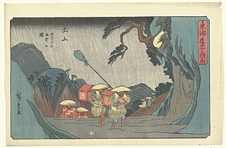
The Hida Mountains, or Northern Alps, is a Japanese mountain range which stretches through Nagano, Toyama and Gifu prefectures. A small portion of the mountains also reach into Niigata Prefecture. William Gowland coined the phrase "Japanese Alps" during his time in Japan, but he was only referring to the Hida Mountains when he used that name. The Kiso and Akaishi mountains received the name in the ensuing years.
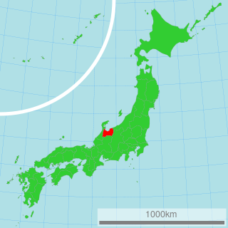
Shirakawa is a village located in Ōno District, Gifu Prefecture, Japan. It is best known for being the site of Shirakawa-gō, a small, traditional village showcasing a building style known as gasshō-zukuri. Together with Gokayama in Nanto, Toyama, it is one of UNESCO's World Heritage Sites.

The Budawang Range, commonly called The Budawangs, a rugged mountain range within the Budawang National Park and the Morton National Park, are part of a spur off the Great Dividing Range and are located in the South Coast region of New South Wales, Australia.

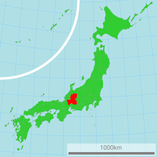
Hakusan National Park is a national park in the Chūbu region of Honshū, Japan. Established in 1962, it spans the borders of Fukui, Gifu, Ishikawa, and Toyama prefectures. Its main geographical feature is Mount Haku. In 1980 an area of 480 km² corresponding to the national park was designated a UNESCO Man and the Biosphere Reserve.

The Lewis Range is a mountain range located in the Rocky Mountains of northern Montana, United States and extreme southern Alberta, Canada. It was formed as a result of the Lewis Overthrust, a geologic thrust fault resulted in the overlying of younger Cretaceous rocks by older Proterozoic rocks. The range is located within Waterton Lakes National Park in Alberta, Canada and Glacier National Park and the Bob Marshall Wilderness Complex in Montana, United States. The highest peak is Mount Cleveland at 10,466 ft (3,190 m).

Mount Bigelow is a long mountain ridge with several summits. It is located in Franklin County and Somerset County, Maine. It is one of Maine's highest summits. The mountain is named after Major Timothy Bigelow who climbed the rugged summit in late October 1775 "for the purpose of observation." Major Bigelow was one of Colonel Benedict Arnold's four division commanders during the 1775 Invasion of Canada. The expeditionary force passed along the Dead River on the northern edge of the Bigelow Range, now dammed into Flagstaff Lake.

Mount Hotaka, also known as Mount Hotakadake, is one of the 100 Famous Japanese Mountains as coined by the media, reaching a height of 3,190 m (10,466 ft). Mount Hotaka is situated in Japan's Hida Mountains and all its major peaks except Mount Maehotaka, lie on the border between the cities of Matsumoto, Nagano Prefecture, and Takayama, Gifu Prefecture. This mountain is located in Chūbu-Sangaku National Park.

The Nandewar Range, a mountain range that is part of the Great Dividing Range, is located in the Northern Tablelands region of New South Wales, Australia. The range is situated approximately 30 km (19 mi) east of the township of Narrabri.

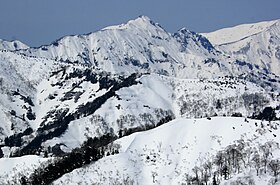
Mount Haku, or Mount Hakusan, is a dormant volcano. The stratovolcano is located on the borders of Gifu and Ishikawa prefectures in Japan. It is thought to have first been active 300,000 to 400,000 years ago, with the most recent eruption occurring in 1659. Along with Mount Tate and Mount Fuji, it is one of Japan's "Three Holy Mountains".
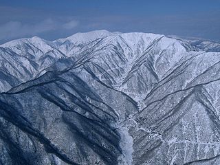
The Ryōhaku Mountains are a mountain range spanning Gifu, Toyama, Ishikawa, Fukui and Shiga prefectures in Japan. It is divided into the Kaetsu Mountains, whose major peak is Mount Haku, and the Etsumi Mountains, whose major peak is Mount Nōgōhaku. The range derives its name from the two major peaks, which both have "haku" in their names. Most of the Ryōhaku Mountains are within Hakusan National Park.

Mount Dainichi is a mountain located in the cities of Gujō and Takayama in Gifu Prefecture, Japan. It is part of the Ryōhaku Mountains and has a height of 1,709 m (5,607 ft). The rain that falls on the mountain flows into three rivers: the Nagara River, the Shō River and the Kuzuryū River.

Mount Kanmuri is a mountain located on the border between Gifu and Fukui prefectures in the Chūbu region of Japan. It is 1,256.6 m (4,123 ft) tall and part of the Ryōhaku Mountains. It is also the source of the Ibi River.
Suzuka Mountains are a mountain range running through Mie Prefecture and along the borders of Gifu and Shiga prefectures in central Japan. The tallest peak in the range is Mount Oike at 1,247 m (4,091 ft). In spite of its height, Mount Oike is not the most visited mountain; that distinction belongs to Mount Gozaisho because of its Gozaisho Ropeway, making reaching the peak much easier.

Mt. Bessan is located on the border of Gujō, Gifu Prefecture, and Hakusan, Ishikawa Prefecture, Japan, and rises to a height of 2,399 m (7,871 ft). There are two triangulation stations at the top of the mountain. Mount Haku can be seen from the north. Bessan Shrine is a short distance from the peak. This area is part of Hakusan National Park.(Note: there is a second Mt. Bessan in located in Toyama Prefecture.)
Mount Nōgōhaku is located on the borders of Gifu and Fukui prefectures in Japan. It is part of the Ryōhaku Mountains and serves as the drainage divide between the Pacific Ocean and the Japan Sea. There is one triangulation station at the top of the mountain.

Mt. Sannomine is located on the border of Gujō, Gifu Prefecture, and Hakusan, Ishikawa Prefecture, Japan, and rises to a height of 2,128 m (6,982 ft).

Heisenji Hakusan Shrine is a Shinto shrine in the city of Katsuyama, Fukui Prefecture, Japan. In the former Modern system of ranked Shinto Shrines, it was a prefectural shrine of Fukui Prefecture. Noted for its mossy gardens, the shrine gardens were designated a national Place of Scenic Beauty (名勝) in 1930 and a National Historic Site of Japan in 1935. Its main festival is held annually on April 20. The area if part of Hakusan National Park.