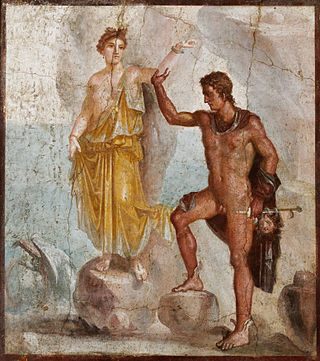
In Greek mythology, Andromeda is the daughter of Cepheus, the king of Aethiopia, and his wife, Cassiopeia. When Cassiopeia boasts that she is more beautiful than the Nereids, Poseidon sends the sea monster Cetus to ravage the coast of Aethiopia as divine punishment. Queen Cassiopeia understands that chaining Andromeda to a rock as a human sacrifice is what will appease Poseidon. Perseus finds her as he is coming back from his quest to decapitate Medusa, and brings her back to Greece to marry her and let her reign as his queen. With the head of Medusa, Perseus petrifies Cetus to stop it from terrorizing the coast any longer.

The Arctic Archipelago, also known as the Canadian Arctic Archipelago, is an archipelago lying to the north of the Canadian continental mainland, excluding Greenland and Iceland.
This is a list of the extreme points of the United Kingdom: the points that are farther north, south, east or west than any other location. Traditionally the extent of the island of Great Britain has stretched "from Land's End to John o' Groats".

Mount Andromeda is located within the Columbia Icefield on the boundary of Banff and Jasper national parks. The mountain can be seen from the Icefields Parkway (#93) near Sunwapta Pass and is 2.3 km WSW of Mount Athabasca. Mt. Andromeda was named in 1938 by Rex Gibson, former president of the Alpine Club of Canada, after Andromeda, the wife of Perseus. From the Climber's Guide:

Booth Island is a Y-shaped island, 5 nautical miles long and rising to 980 metres (3,220 ft) in the northeast part of the Wilhelm Archipelago, Antarctica.
The Victory Mountains is a major group of mountains in Victoria Land, Antarctica, about 100 nautical miles long and 50 nautical miles wide, which is bounded primarily by Mariner and Tucker glaciers and the Ross Sea. They are north of the Mountaineer Range, east of the Freyberg Mountains and south of the Concord Mountains and the Admiralty Mountains. The division between the Victory Mountains and the Concord Mountains is not precise but apparently lies in the vicinity of Thomson Peak.

The Executive Committee Range is a range consisting of five major volcanoes, which trends north-south for 50 nautical miles along the 126th meridian west, in Marie Byrd Land, Antarctica.
Mount Andromeda is, at 550 metres (1,800 ft), the higher and more southerly of the twin ice domes, this one marking the summit of Candlemas Island, South Sandwich Islands. It was named by the United Kingdom Antarctic Place-Names Committee in 1971 in association with nearby Mount Perseus, the name referring to Andromeda, the mythical heroine rescued from a sea monster by the hero Perseus.
Quarles Range is a high and rugged range of the Queen Maud Mountains, extending from the polar plateau between Cooper Glacier and Bowman Glacier and terminating near the edge of Ross Ice Shelf.
Wilson Hills is a group of scattered hills, nunataks and ridges that extend northwest–southeast about 70 nautical miles between Matusevich Glacier and Pryor Glacier in Antarctica.
The Mariner Glacier is a major glacier over 60 nautical miles long, descending southeast from the plateau of Victoria Land, Antarctica, between Mountaineer Range and Malta Plateau, and terminating at Lady Newnes Bay, Ross Sea, where it forms the floating Mariner Glacier Tongue.
The Tabarin Peninsula is a peninsula 15 nautical miles long and 5 to 12 nautical miles wide, lying south of the trough between Hope Bay and Duse Bay and forming the east extremity of Trinity Peninsula in the Antarctic Peninsula.
Chimaera Flats is a broad stretch of flat sand with a smooth surface only a few metres above sea level, between Medusa Pool and Gorgon Pool on Candlemas Island, South Sandwich Islands. The name applied by the UK Antarctic Place-Names Committee in 1971 refers to the chimaera, a mythical fire-eating monster.
Condor Peninsula is a mountainous, ice-covered peninsula, 30 nautical miles long and 10 to 15 nautical miles wide, between Odom Inlet and Hilton Inlet on the east coast of Palmer Land, Antarctica.
Mount Moffat is a mountain, 1,250 metres (4,100 ft) high, standing 4 nautical miles northeast of Mount Ege in the Neptune Range, Pensacola Mountains, Antarctica.
Gambacorta Peak is a peak 1,840 metres (6,040 ft) high, standing 4 nautical miles east of Mount Kaschak in the southern Neptune Range, Pensacola Mountains, Antarctica.
Mount Machatschek is a prominent, mainly snow-covered mountain in northern Adelaide Island, Antarctica, about 14 nautical miles (26 km) southwest of Mount Velain. It was mapped from air photos taken by the Ronne Antarctic Research Expedition (1947–48) and the Falkland Islands and Dependencies Aerial Survey Expedition (1956–57), and was named by the UK Antarctic Place-Names Committee after Austrian geomorphologist Fritz Machatschek (1876–1957), who was the joint author with Erich von Drygalski of Gletscherkunde, 1942.
Blue Glacier is a large glacier which flows into Bowers Piedmont Glacier about 10 nautical miles south of New Harbour, in Victoria Land, Antarctica. It was discovered by the British National Antarctic Expedition (BrNAE) under Robert Falcon Scott, 1901–04, who gave it this name because of its clear blue ice at the time of discovery.
Bone Bay is a rectangular bay along the northwest coast of Trinity Peninsula, Antarctica. It is nearly 10 nautical miles wide at the entrance between Notter Point and Cape Roquemaurel.