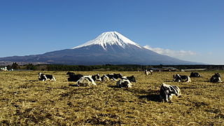
Mount Fuji, located on Honshū, is the highest volcano in Japan at 3,776.24 m (12,389 ft), 2nd-highest peak of an island (volcanic) in Asia, and 7th-highest peak of an island in the world. It is a dormant stratovolcano that last erupted in 1707–1708. Mount Fuji lies about 100 kilometers (60 mi) south-west of Tokyo, and can be seen from there on a clear day. Mount Fuji's exceptionally symmetrical cone, which is snow-capped for about 5 months a year, is a well-known symbol of Japan and it is frequently depicted in art and photographs, as well as visited by sightseers and climbers.
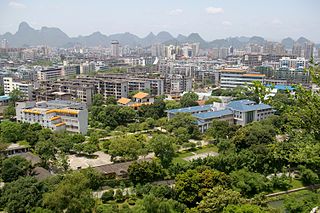
Guilin, formerly romanized as Kweilin, is a prefecture-level city in the northeast of China's Guangxi Zhuang Autonomous Region. It is situated on the west bank of the Li River and borders Hunan to the north. Its name means "Forest of Sweet Osmanthus", owing to the large number of fragrant sweet osmanthus trees located in the region. The city has long been renowned for its scenery of karst topography and is one of China's most popular tourist destinations.

Purple Mountain or Zijin Shan is located on the eastern side of Nanjing in Jiangsu province, China. It is 448.2 m (1467 ft) high, with the lowest point 30 m (98 ft). Its peaks are often found enveloped in mysterious purple and golden clouds at dawn and dusk, hence its name.
100 Famous Japanese Mountains is a book composed in 1964 by mountaineer and author Kyūya Fukada. The list became famous when Crown Prince Naruhito took note of it. The list has been the topic of NHK documentaries, and other hiking books.

Fuxing District (Atayal: Pyasan; Chinese: 復興區; pinyin: Fùxīng Qū), formerly known as Fuxing Township or Fu-Hsing Township (Chinese: 復興鄉; Hanyu Pinyin: Fùxīng Xiāng; Tongyong Pinyin: Fùsing Siang; Wade–Giles: Fu4-hsing1 Hsiang1) is a mountain indigenous district in eastern Taoyuan City, Taiwan. The main population is the Atayal people of the Taiwanese aborigines. Lalashan (拉拉山) is a major feature of Fuxing, and the Shimen Reservoir, formed by Shimen Dam, is a popular nearby site. Fuxing District is, by area, the largest district in Taoyuan City.
Shandong Airlines Co,.Ltd. is an airline based in the Shandong Airlines Center in Jinan, Shandong. The Chinese carrier operates a sizable domestic network from Jinan, Qingdao and Yantai to major cities across China, together with an international network to regional Asian destinations. The airline's two largest shareholders are Shandong Aviation Group with a 42% controlling stake and Air China, a strategic partner, holding 22.8% of the airlines shares.

Kunshan is a county-level city in southeastern Jiangsu province with Shanghai bordering its eastern border and Suzhou on its western boundary. It is under the administration of the prefecture-level city of Suzhou.

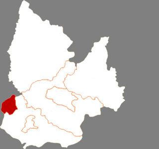
Rongcheng is a county-level city of the prefecture-level city of Weihai, at the eastern extremity of Shandong Province, China, looking out to the Yellow Sea in all directions but the west.

Grotto-heavens are a type of sacred Taoist site. Grotto-heavens are usually caves, grottoes, mountain hollows, or other underground spaces. Because every community was supposed to have access to at least one grotto, there were many of them all over China. They were first organized systematically in the Tang Dynasty by Sima Chengzhen 司馬承禎 and Du Guangting 杜光庭 (850-933). The most sacred of these sites were divided into two types: The ten greater grotto-heavens and the thirty-six lesser grotto-heavens.

The Songshan–Xindian or Green line is a line of the Taipei Metro. Parts of the line runs under the Roosevelt Road, following the route of the former Xindian railway line, which ceased service in 1965 on its southern section.

Jinggangshan Airport, also known as Ji'an Airport, is an airport serving the city of Ji'an in Jiangxi province, China.

Anisodamine, also known as 7β-hydroxyhyoscyamine, is an anticholinergic and α1 adrenergic receptor antagonist used in the treatment of acute circulatory shock in China. It is given orally or by injection, as a racemic mixture (racanisodamine) or as a hydrobromide salt. Eye drops at 0.5% concentration for slowing the progression is also available in China.

Mile is located in Honghe Hani and Yi Autonomous Prefecture, Yunnan province, China.

Hongshan District forms part of the urban core of and is one of 13 districts of Wuhan, the capital of Hubei province, People's Republic of China. The district is named for Mount Hong, located near East Lake. It is the most populous of all the districts, and is the most spacious but least densely populated among the city's seven core districts.
Diaobingshan is a city in the northeast of Liaoning province in Northeast China. It is under the administration of Tieling City, which lies 30 kilometres (19 mi) to the southeast.

Xinzhou Wutaishan Airport, formerly Dingxiang Airport, is a civilian and military dual-use airport in Dingxiang County, Shanxi Province, China. It serves the city of Xinzhou and Wutaishan, a Buddhist sacred mountain and World Heritage Site. The airport is located 33 kilometers from Xinzhou. Construction started in June 2010 with a total investment of 476 million yuan, and the airport was opened on 26 December 2015.

The seventeenth season of the One Piece anime series was produced by Toei Animation, and directed by Hiroaki Miyamoto and Toshinori Fukuzawa. The season began broadcasting in Japan on Fuji Television from January 19, 2014 to June 19, 2016. Like the rest of the series, it follows the adventures of Monkey D. Luffy and his Straw Hat Pirates. The first DVD compilation of this season was released on July 2, 2014, with individual volumes being released monthly. The story arc, called "Dressrosa", adapts material beginning from the end of the 70th volume to the middle of the 80th volume of the manga by Eiichiro Oda. The Straw Hats land in Dressrosa, an island controlled by the warlord Donquixote Doflamingo. Upon learning of Doflamingo's conquering of the kingdom, the Straw Hats team up with the Revolutionaries and the kingdom's deposed princess Viola to overthrow Doflamingo and save the island, Dressrosa.