Related Research Articles

Canadian Forces Base Summerside was an air force base located in St. Eleanors, Prince Edward Island, Canada, now part of the city of Summerside.

Unorganized North Algoma District is an unorganized area in northeastern Ontario, Canada, comprising all areas in Algoma District, north of the Sault Ste. Marie to Elliot Lake corridor, which are not part of an incorporated municipality or a First Nation. It covers 44,077.03 km2 (17,018.24 sq mi) of land, and had a population of 5739 in 2016.
Knutsford is an unincorporated rural community in Prince County, Prince Edward Island.
RCAF Station Mount Pleasant was a Royal Canadian Air Force (RCAF) station in Mount Pleasant, Prince Edward Island, Canada. Two of its runways remain in use by members of the Experimental Aircraft Association.
Alberton is a Canadian town located in Prince County, Prince Edward Island. It is situated in the western part of the county in the township of Lot 5. The population was 1,145 as of the 2016 census.
RCAF Station Charlottetown was a Royal Canadian Air Force station located in Sherwood, Prince Edward Island. Today's Charlottetown Airport maintains a remnant of the airfield's runways near its general aviation terminal, but all buildings and most infrastructure have been removed.

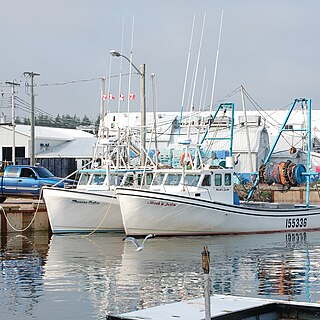
Prince County is located in western Prince Edward Island, Canada. The county's defining geographic feature is Malpeque Bay, a sub-basin of the Gulf of St. Lawrence, which creates the narrowest portion of Prince Edward Island's landmass, an isthmus upon which the city of Summerside is located.
Murray Harbour is a community that holds rural municipality status in Prince Edward Island, Canada. It is located in southeastern Kings County.
Miminegash is a municipality that holds community status in Prince Edward Island, Canada. It is located 8 miles (13 km) northwest of Alberton and 11 miles (18 km) southwest of Tignish. It is part of a small area in Lot 3 known as either the St. Louis, Palmer Road, or Miminegash area. This area is often associated with Tignish due to the shared Acadian roots between these areas.

Route 2, also known as Veterans Memorial Highway and the All Weather Highway, is a 216-kilometre (134 mi) two-lane uncontrolled access highway traversing Prince Edward Island, Canada from Tignish to Souris. Route 2 was recognized as the first numbered highway in the province in 1890, when it opened between Charlottetown and Summerside.
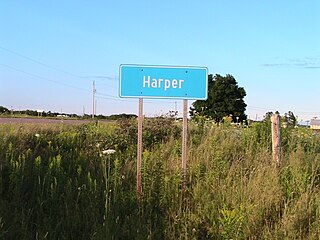
Harper is a Canadian rural community located in western Prince County, Prince Edward Island.
Ascension Road, labelled Route 160, is a 2-lane collector highway in western Prince County, Prince Edward Island, Canada. It is located 2 miles (3.2 km) NW of the community of Tignish. Its maximum speed limit is 80 kilometres per hour (50 mph).

Palmer Road, labelled Route 156, is a 2-lane collector highway in western Prince County, Prince Edward Island, Canada. It is between the communities of Tignish and Miminegash. Its maximum speed limit is 80 km/h (50 mph). The road is considered part of two larger communities, Tignish and Miminegash.
Ellerslie Road, labelled Route 133, is a 2-lane collector highway in Prince County, Prince Edward Island, Canada. It is located 2.5–5 miles NE of the community of Tyne Valley and is located within the community of Ellerslie. Its maximum speed limit is 80 km/h (50 mph).
Abram-Village is a Canadian rural municipality located in Prince County, Prince Edward Island.

Tignish-Palmer Road is a provincial electoral district for the Legislative Assembly of Prince Edward Island, Canada. It was formerly Tignish-DeBlois from 1996 to 2007.
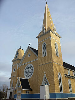
The Immaculate Conception Church, known colloquially as Palmer Road Church is a 19th-century Roman Catholic church located in Palmer Road, Prince Edward Island, Canada. The church is a white wooden Gothic architecture, and it was constructed in 1892.
St. Eleanors is a neighbourhood in the city of Summerside, Prince Edward Island, Canada.
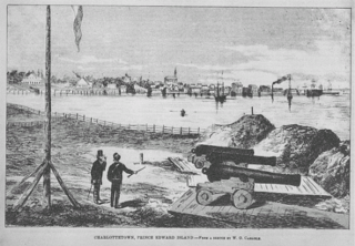
The History of Charlottetown can be traced back to the original French military settlement established on the site in 1720. Over the years Charlottetown has grown to become the largest and most important city on Prince Edward Island.
References
Coordinates: 46°34′50″N64°0′32″W / 46.58056°N 64.00889°W
| | This Prince Edward Island location article is a stub. You can help Wikipedia by expanding it. |