
Ballarat is a city in the Central Highlands of Victoria, Australia. Ballarat has a population of 119,096 as of March 2024 making it the third-largest urban inland city in Australia and the third-largest city in Victoria.
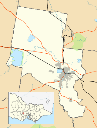
The City of Ballarat is a local government area in the west of the state of Victoria, Australia. It covers an area of 739 square kilometres (285 sq mi) and, in June 2018, had a population of 107,325. It is primarily urban with the vast majority of its population living in the Greater Ballarat urban area, while other significant settlements within the LGA include Buninyong, Waubra, Learmonth and Addington. It was formed on 6 May 1994 from the amalgamation of the City of Ballarat, Shire of Ballarat, Borough of Sebastopol and parts of the Shire of Bungaree, Shire of Buninyong, Shire of Grenville and Shire of Ripon.

Sovereign Hill is an open-air museum in Golden Point, a suburb of Ballarat, Victoria, Australia. Sovereign Hill depicts Ballarat's first ten years after the discovery of gold there in 1851 and has become a nationally acclaimed tourist attraction. It is one of Victoria's most popular attractions and Ballarat's most famous.

Maryborough is a town in Victoria, Australia, on the Pyrenees Highway, 58 kilometres (36 mi) north of Ballarat and 168 kilometres (104 mi) northwest of Melbourne, in the Shire of Central Goldfields. At the 2021 census, the urban centre had a population of 7,769., while the larger Level 2 Statistical Area which includes the urban fringe, had 8,160, both an increase of more than 3% since 2016.
Lakeside Mental Hospital, originally known as Ballarat Asylum, later as Ballarat Hospital for the Insane and finally, before its closure, as Lakeside Psychiatric Hospital, was an Australian psychiatric hospital located in the suburb of Wendouree, the north-western fringe of Ballarat, Victoria, Australia.

Ballarat railway station is located on the Serviceton line in Victoria, Australia. It serves the city of Ballarat, and opened on 11 April 1862 as Ballarat West. It was renamed Ballarat in 1865.

The Waubra wind farm is located on both sides of the Sunraysia Highway 35 km north-west of Ballarat in Victoria, Australia. Upon its completion in July 2009, it was the largest wind farm in Australia and was the largest wind farm by number of turbines and total capacity in the southern hemisphere.
ABC Ballarat, callsign 3CRR, is an ABC Local Radio station in Ballarat, Victoria, Australia. ABC Ballarat is one of the newest stations in the network, opened on 30 June 2003. The station is the largest regional ABC station in Victoria and is home to a team of broadcasters, journalists, program-makers and online producers, providing news, programs and online content primarily about serves Ballarat, Ararat and Daylesford, as well as parts of south-west Victoria including Hamilton, Port Fairy, and Warrnambool through ABC South West Victoria.
Ballarat Clarendon College is a private, co-educational, day and boarding school, located in Ballarat, Victoria, Australia.

The Shire of Ballarat was a local government area immediately to the northwest and west of the regional city of Ballarat, Victoria, Australia. The shire covered an area of 481.74 square kilometres (186.0 sq mi), and existed from 1856 until 1994.
Ballarat Secondary College is a multi-campus college, formed in 1993 by the amalgamation of three existing secondary colleges. The college now comprises two campuses, Woodman's Hill and Mount Rowan, each having different uniforms, crests and administrations. The school has applied to have both campuses registered as separate schools and is awaiting formal approval. In 2016, Ballarat Secondary College improved VCE scores by 20 percent. Over a five-year period, 2012 to 2016, the school was the fourth most improved in VCE performance in Victoria.
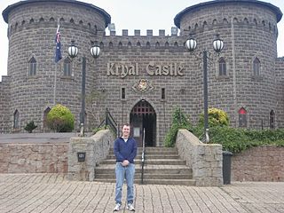
Kryal Castle is a replica medieval castle located eight kilometres east of Ballarat, Australia, at Leigh Creek, just north of Dunnstown, in the foothills of Mount Warrenheip.

The Mount Emu Creek, a perennial creek of the Glenelg Hopkins catchment, is located in the Western District of Victoria, Australia.
The Macedon Ranges is a region in Central Victoria, known for its expansive native forests, vibrant arts scene, thriving food and wine industries and natural attractions such as Hanging Rock and Mount Macedon. It is located in between the cities of Bendigo and Melbourne. It includes the towns of Clarkefield, Gisborne South, Gisborne, Kyneton, Lancefield, Macedon, Malmsbury, Mount Macedon, New Gisborne, Riddells Creek, Romsey and Woodend. It is governed and administered by the Macedon Ranges Shire Council.
Mount Pisgah is a small volcanic lava dome 11 km from Ballarat, Victoria, Australia. The name derives from the summit of the Biblical Mount Nebo, from which Moses first saw the Promised Land.

The Yarrowee River is a perennial river of the Corangamite catchment, located in the Central Highlands region of the Australian state of Victoria.
Eastern Oval is a cricket and Australian rules football ground in the city of Ballarat, Victoria, Australia.

Federation University Australia is a public, multi-sector university based in Ballarat in Victoria, Australia. The university also has campuses in Ararat, Horsham, Stawell, Churchill, Berwick, and Brisbane, as well as online technical and further education (TAFE) courses and Horsham's higher education nursing program.
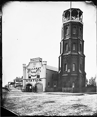
The Ballarat Fire Station is an historic fire station in Ballarat, Victoria, Australia which was opened in 1856.

Mount Kooroocheang, also known as Smeaton Hill, is a dormant volcano, situated near the town of Smeaton, Victoria, Australia. It is about 140 km northwest of Melbourne. It is a large composite scoria cone. Mount Kooroocheang is one of the largest eruption points on the Victorian Central Plateau, and is about 230 metres in height above the surrounding plains and 676 metres above sea level. There is a communications tower on the summit.
