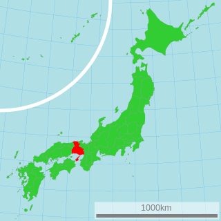
Maniwa is a city located in north-central Okayama Prefecture, Japan. Its northernmost border meets that of Tottori Prefecture.

Mount Nishigatake is a 727-metre-high (2,385 ft) mountain in Sasayama, Hyōgo, Japan.

Mount Ōfuna is a 653.1 metre high Japanese mountain in Sanda, Hyōgo, Japan.
Mount Hatsuka is a 524.0 meter high Japanese mountain in Sanda, Hyōgo, Japan. Another name of this mountain is Mount Koge.

Mount Hyōno is a mountain on the border of Yabu, Hyōgo Prefecture, and Wakasa, Tottori Prefecture, in Japan. It is the highest mountain in Hyōgo Prefecture. This mountain is one of the 200 famous mountains in Japan. Other names of this mountain are Suga-no-sen, Hyō-zan, Hyō-no-yama, Kōri-no-yama.

Mount Ushiro is a mountain on the border of Shisō, Hyōgo Prefecture, and Mimasaka, Okayama Prefecture, Japan. It is the highest mountain in Okayama Prefecture and the third highest mountain in Hyōgo Prefecture, after Mount Hyōno and Mount Mimuro. In Hyōgo Prefecture this mountain is also known as Itabami-san and in Tottori Prefecture it is also known as Ushiro-no-sen.

Mount Seppiko is a mountain or mountains in Himeji, Hyōgo, Japan. This mountain is one of the San-hiko-san, three Hiko Shugendō mountains in Japan, and also one of Hyōgo 50 mountains, and Kinki 100 mountains. It forms part of Seppiko-Mineyama Prefectural Natural Park.

Mount Haku is a mountain in Nishiwaki, Hyōgo Prefecture, Japan. This mountain is one of the Hyōgo 50 Mountains.

Mount Nagi, is a mountain located on the border of Chizu, Tottori Prefecture, and Nagi, Okayama Prefecture, Japan. The other reading of this mountain's kanji is Nagisen.

Mount Senjō is a 3,032.6-metre-high (9,949.5 ft) mountain on the border of Minami-Alps, Yamanashi, and Ina, Nagano, in Japan. This mountain is one of the major peaks of the Akaishi Mountains, and is one of the most popular peaks in the range. This mountain is also one of the 100 Famous Japanese Mountains.

Mount Mimuro is a mountain on the border of Shisō, Hyōgo Prefecture, and Wakasa, Tottori Prefecture, Japan. The height is 1,358.0 m (4,455 ft), and this mountains is the second highest mountain in Hyōgo Prefecture after Mount Hyōno.

Mount Taka is a 720.8 m (2,365 ft) mountain of the Hokusetsu Mountains, located on the border of Inagawa, Hyōgo and Nose, Ōsaka, Japan. This mountain is one of Osaka 50 mountains, and an important part of Hokusetsu Natural Park.

Mount Myōken is a 1,135.5 m (3,725 ft) mountain on the border of Yabu and Kami, Mikata, Hyogo, Japan. This mountain is one of Hyōgo 50, and a part of Hyonosen-Ushiroyama-Nagisan Quasi-National Park. The other name of this mountain is Mount Ishihara.

Mount Yajuro is a 715.1 m (2,346 ft) mountain of Tanba Highland, located in Sasayama, Hyōgo, Japan. This mountain is one of Hyōgo 50 mountains. This mountain is a part of Inagawa Natural Park.

Mount Takami is a 1,248.3 m (4,095 ft) mountain of Daiko Mountains, which is located on the border of Higashiyoshino, Nara, and Matsusaka, Mie, Japan

Mount Miyama is a 790.5 m (2,594 ft) mountain, located on the border of Nose, Osaka and Nantan, Kyoto, Japan.

Mount Kasagata is a 939.4 m (3,082 ft) mountain in the Chūgoku Mountains, located on the border of Taka and Kamikawa, Hyōgo, Japan. This mountain is one of Hyōgo 50 mountains. This mountain is an important center of Kasagatayama-Sengamine Prefectural Natural Park.

The Harima Expressway is a national expressway in Hyōgo Prefecture, Japan. It is owned and operated by West Nippon Expressway Company. It is signed as E29 under the Ministry of Land, Infrastructure, Transport and Tourism's "2016 Proposal for Realization of Expressway Numbering."

The Tottori Expressway is an expressway connecting Sayō in Hyōgo Prefecture and Tottori, the capital and largest city in Tottori Prefecture. It is owned and operated by partly by the West Nippon Expressway Company and the Ministry of Land, Infrastructure, Transport and Tourism. The expressway is signed as an auxiliary route of National Route 373 as well as E29 under the Ministry of Land, Infrastructure, Transport and Tourism's "2016 Proposal for Realization of Expressway Numbering."