The Reedy Glacier is a major glacier in Antarctica, over 100 nautical miles long and 6 to 12 nautical miles wide, descending from the polar plateau to the Ross Ice Shelf between the Michigan Plateau and Wisconsin Range in the Transantarctic Mountains. It marks the limits of the Queen Maud Mountains on the west and the Horlick Mountains on the east.
Lillie Glacier is a large glacier in Antarctica, about 100 nautical miles long and 10 nautical miles wide. It lies between the Bowers Mountains on the west and the Concord Mountains and Anare Mountains on the east, flowing to Ob' Bay on the coast and forming the Lillie Glacier Tongue.
Tucker Glacier is a major valley glacier of Victoria Land, Antarctica, about 90 nautical miles long, flowing southeast between the Admiralty Mountains and the Victory Mountains to the Ross Sea. There is a snow saddle at the glacier's head, just west of Homerun Range, from which the Ebbe Glacier flows northwestward.
The Jones Mountains are an isolated group of mountains, trending generally east–west for 27 nautical miles, situated on the Eights Coast, Ellsworth Land, Antarctica, about 50 nautical miles south of Dustin Island.

The Sweeney Mountains are a group of mountains of moderate height and about 40 nautical miles extent, located 30 nautical miles north of the Hauberg Mountains in eastern Ellsworth Land, Antarctica.
Kohler Range is a mountain range in Marie Byrd Land, Antarctica. The range is about 40 nautical miles long and stands between the base of Martin Peninsula and Smith Glacier. The range consists of two ice-covered plateaus punctuated by several rock peaks and bluffs. The plateaus are oriented East-West and are separated by the Kohler Glacier, a distributary which flows north from Smith Glacier.
Borchgrevink Glacier is a large glacier in the Victory Mountains, Victoria Land, Antarctica. It drains south between Malta Plateau and Daniell Peninsula, and thence projects into Glacier Strait, Ross Sea, as a floating glacier tongue.

The Prince Charles Mountains are a major group of mountains in Mac. Robertson Land in Antarctica, including the Athos Range, the Porthos Range, and the Aramis Range. The highest peak is Mount Menzies, with a height of 3,228 m (10,591 ft). Other prominent peaks are Mount Izabelle and Mount Stinear. These mountains, together with other scattered peaks, form an arc about 420 km (260 mi) long, extending from the vicinity of Mount Starlight in the north to Goodspeed Nunataks in the south.
Mount Joyce is a prominent, dome-shaped mountain, 1,830 metres (6,000 ft) high, standing 8 nautical miles (15 km) northwest of Mount Howard in the Prince Albert Mountains of Victoria Land, Antarctica.
The Latady Mountains are a group of mountains rising west of Gardner Inlet and between Wetmore Glacier and Ketchum Glacier, in southeastern Palmer Land, Antarctica.
Campbell Glacier is a glacier, about 60 nautical miles long, originating near the south end of Mesa Range and draining southeast between the Deep Freeze Range and Mount Melbourne to discharge into north Terra Nova Bay in Victoria Land, Antarctica.
The Werner Mountains are a group of mountains located just west-southwest of New Bedford Inlet and between the Meinardus Glacier and Bryan Glacier, in Palmer Land, Antarctica.
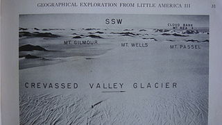
The Denfeld Mountains are a group of scattered mountains between Crevasse Valley Glacier and Arthur Glacier in the Ford Ranges of Marie Byrd Land, Antarctica.
Fry Glacier is a glacier draining the slopes at the northeast corner of the Convoy Range and flowing along the south end of the Kirkwood Range into Tripp Bay, Victoria Land, Antarctica. It was first charted by the British Antarctic Expedition, 1907–09, and named for A.M. Fry, a contributor to the expedition.
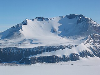
Mount Dixon is a snow-covered stratovolcano, 705 metres (2,310 ft) high, standing 0.7 nautical miles (1.3 km) west of Anzac Peak on the Laurens Peninsula, Heard Island. The feature appears to have been roughly charted on an 1860 sketch map by Captain H.C. Chester, an American sealer operating in the area during this period. It was surveyed in 1948 by the Australian National Antarctic Research Expeditions (ANARE), and named by them for Lieutenant Commander George M. Dixon, RANVR, commanding officer of HMAS Labuan which landed and relieved the 1948 and 1949 ANARE parties.

Mount Mohl is a mountain, 3,710 metres (12,170 ft) high, at the east side of Vinson Massif, surmounting the ridge between the heads of Dater Glacier and Thomas Glacier, in the Sentinel Range of the Ellsworth Mountains, Antarctica. It is connected to Doyran Heights to the northeast by Goreme Col.
Fremantle Peak is a peak, 2,375 metres (7,800 ft) high, standing 0.4 nautical miles (0.7 km) northeast of the Dome, near the summit of Heard Island. It was surveyed in 1948 by the Australian National Antarctic Research Expeditions, and named by them after the port of Fremantle, the final point of embarkation for the expedition.
Separation Range is the northeastern branch of the Commonwealth Range in the Queen Maud Mountains, Antarctica. The branch starts at about 84°20'S, and forms two chains of mountains separated by Hood Glacier. The Separation Range, about 30 nautical miles long, terminates to the north at the Ross Ice Shelf. Named by the New Zealand Alpine Club Antarctic Expedition, 1959–60.
Blue Glacier is a large glacier which flows into Bowers Piedmont Glacier about 10 nautical miles south of New Harbour, in Victoria Land, Antarctica. It was discovered by the British National Antarctic Expedition (BrNAE) under Robert Falcon Scott, 1901–04, who gave it this name because of its clear blue ice at the time of discovery.
