
Mount Washington, is an ultra-prominent mountain in the state of New Hampshire. It is the highest peak in the Northeastern United States at 6,288.2 ft (1,916.6 m) and the most topographically prominent mountain east of the Mississippi River.

Mount Mitchell is the highest peak of the Appalachian Mountains and the highest peak in mainland North America east of the Mississippi River. It is located near Burnsville in Yancey County, North Carolina in the Black Mountain subrange of the Appalachians about 19 miles (31 km) northeast of Asheville. It is protected by Mount Mitchell State Park and surrounded by the Pisgah National Forest. Mount Mitchell's elevation is 6,684 feet (2,037 m) above sea level. Mount Mitchell is ranked 31st by topographic isolation.

The Presidential Range is a mountain range located in the White Mountains of the U.S. state of New Hampshire. Containing the highest peaks of the Whites, its most notable summits are named for American presidents, followed by prominent public figures of the 18th and 19th centuries. The Presidential Range is notorious for having some of the worst weather on Earth, mainly because of the unpredictability of high wind speeds and whiteout conditions on the higher summits. Because of the poor weather conditions, the Presidential Range is often used for mountaineering training for those who go on to climb some of the world's highest mountains, including K2 and Everest.

Alpine climate is the typical climate for elevations above the tree line, where trees fail to grow due to cold. This climate is also referred to as a mountain climate or highland climate.

Mount Mansfield is the highest mountain in Vermont, reaching an elevation of 4,393 feet (1,339 m) above sea level. Located in the northwest of the state, it is also the highest peak in the Green Mountains. Its summit is located within the town of Underhill in Chittenden County; the ridgeline, including some secondary peaks, extends into the town of Stowe in Lamoille County, and the mountain's flanks also reach into the town of Cambridge.

Mount Adams, elevation 5,793 feet (1,766 m) above sea level, is a mountain in New Hampshire, the second highest peak in the Northeast United States after its nearby neighbor, Mount Washington. Located in the northern Presidential Range, Mount Adams was named after John Adams, the second President of the United States. It was given this name on July 31, 1820. To the northeast is Mount Madison and to the southwest is Mount Jefferson. From the summit, Mount Washington can be seen directly to the south.

Greater Boston is the metropolitan region of New England encompassing the municipality of Boston, the capital of the U.S. state of Massachusetts and the most populous city in New England, and its surrounding areas. The most stringent definition of the region, used by the Metropolitan Area Planning Council, consists of most of the eastern third of mainland Massachusetts, excluding the Merrimack Valley and most of Southeastern Massachusetts, though most definitions include much of these areas and portions of southern New Hampshire.

The White Mountain National Forest (WMNF) is a federally managed forest contained within the White Mountains in the northeastern United States. It was established in 1918 as a result of the Weeks Act of 1911; federal acquisition of land had already begun in 1914. It has a total area of 750,852 acres (303,859 ha). Most of the WMNF is in New Hampshire; a small part is in the neighboring state of Maine. Conservationist and community activist Katherine Sleeper Walden was instrumental in securing at-risk land for the forest, including thousands of acres in the region surrounding the locally famous Bowl near Wonalancet.

Mount Hamilton is a mountain in the Diablo Range in Santa Clara County, California. The mountain's peak, at 4,265 feet (1,300 m), overlooks the heavily urbanized Santa Clara Valley and is the site of Lick Observatory, the world's first permanently occupied mountain-top observatory. The asteroid 452 Hamiltonia, discovered in 1899, is named after the mountain. Golden eagle nesting sites are found on the slopes of Mount Hamilton. On clear days, Mount Tamalpais, the Santa Cruz Mountains, Monterey Bay, the Monterey Peninsula, and even Yosemite National Park are visible from the summit of the mountain.
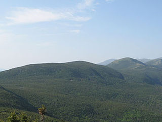
Mount Pierce is a mountain in the Presidential Range in the White Mountains of New Hampshire that is approximately 4,310 feet (1,310 m) high. Formerly called Mount Clinton for 19th-century governor DeWitt Clinton of New York, in 1913 it was renamed after President Franklin Pierce (1804–1869), the only president born in New Hampshire, although it was several decades before the name was widely recognized. Its summit offers a wide view of New Hampshire's mountains.

Mount Sunapee is a 5-mile-long (8.0 km) mountain ridge in the towns of Newbury and Goshen in western New Hampshire, United States. Its highest peak, at the north end of the mountain, is 2,726 feet (831 m) above sea level. The mountain has three secondary peaks, White Ledges at 2,716 ft (828 m); North Peak at 2,280 ft (695 m); and South Peak at 2,608 ft (795 m). The north end of the mountain, including the summit, is within Mount Sunapee State Park, which encompasses 3.85 square miles (10.0 km2) and is home to the popular Mount Sunapee Resort. The mountain extends south to Pillsbury State Park in the towns of Goshen and Washington.
The Mount Washington Auto Road—originally the Mount Washington Carriage Road—is a 7.6 mi (12.2 km) private toll road in southern Coos County, New Hampshire that extends from New Hampshire Route 16 in Green's Grant, just north of Pinkham Notch, westward across Pinkham's Grant and Thompson and Meserve's Purchase to the summit of Mount Washington in the White Mountains of the US state of New Hampshire. The road climbs 4,618 ft (1,408 m) from an altitude of 1,527 ft (465 m) at the bottom to 6,145 ft (1,873 m) at the top, an average gradient of 11.6%. The road was completed and opened to the public in 1861.

Mount Carrigain is a mountain located in Grafton County, New Hampshire. The mountain is named after Phillip Carrigain, NH Secretary of State (1805–10), and is on the south side of the Pemigewasset Wilderness, the source of the East Branch of the Pemigewasset River in the heart of the White Mountains, between Franconia Notch and Crawford Notch. Carrigain is flanked to the northeast beyond Carrigain's Vose Spur by Mount Anderson and Mount Lowell across Carrigain Notch, and to the southwest by Mount Hancock. It has a fire tower at the summit, providing 360 degree views of the surrounding wilderness.

Mount Rose is the highest mountain in Washoe County, within the Carson Range of Nevada, United States. It ranks thirty-seventh among the most topographically prominent peaks in the state. It is also both the highest and most topographically prominent peak of the greater Sierra Nevada range within the state of Nevada, and the third most topographically prominent peak in the Sierra Nevada overall. It is located in the Mount Rose Wilderness of the Humboldt-Toiyabe National Forest. An extinct volcano, the mountain is in between Lake Tahoe and Reno. State Route 431 traverses Mount Rose Summit southeast of Mount Rose. Due to the high elevation, most of the precipitation that falls on the mountain is snow. The view from Mount Rose facing east is the Truckee Meadows, the second largest population center in Nevada.

Arizona is a landlocked state situated in the southwestern region of the United States of America. It has a vast and diverse geography famous for its deep canyons, high- and low-elevation deserts, numerous natural rock formations, and volcanic mountain ranges. Arizona shares land borders with Utah to the north, the Mexican state of Sonora to the south, New Mexico to the east, and Nevada to the northwest, as well as water borders with California and the Mexican state of Baja California to the southwest along the Colorado River. Arizona is also one of the Four Corners states and is diagonally adjacent to Colorado.
The Presidential Traverse is a strenuous and sometimes dangerous trek over the Presidential Range of New Hampshire's White Mountains. Contained almost entirely in the 750,000-acre (3,000 km2) White Mountain National Forest, the Presidential Range is a string of summits in excess of 4,000 feet (1,200 m). To complete the traverse, one must begin at either the northern or southern terminus of the Presidential Range and finish at the opposing end. Beginning the journey at the northern end at Mount Madison, one would pass through the townships of Low and Burbank's Grant, Thompson and Meserve's Purchase, Sargent's Purchase, Chandler's Purchase, and Bean's Grant, all of which are in Coös County.

Washington is the northwesternmost state of the contiguous United States. It borders Idaho to the east, bounded mostly by the meridian running north from the confluence of the Snake River and Clearwater River, except for the southernmost section where the border follows the Snake River. Oregon is to the south, with the Columbia River forming the western part and the 46th parallel forming the eastern part of the Oregon–Washington border. During Washington's partition from Oregon, the original plan for the border followed the Columbia River east until the confluence with the Snake, and then would have followed the Snake River east; this was changed to keep Walla Walla's fertile farmland in Washington.

The climate of New England varies greatly across its 500-mile (800 km) span from northern Maine to southern Connecticut.

