
The Arctic Archipelago, also known as the Canadian Arctic Archipelago, is an archipelago lying to the north of the Canadian continental mainland, excluding Greenland.

Woodward is an unincorporated community and census-designated place in Centre County, Pennsylvania, United States. It is part of the State College, Pennsylvania, Metropolitan Statistical Area. The population was 110 at the 2010 census.

The Rush–Bagot Treaty or Rush–Bagot Disarmament was a treaty between the United States and Great Britain limiting naval armaments on the Great Lakes and Lake Champlain, following the War of 1812. It was ratified by the United States Senate on April 16, 1818, and was confirmed by Canada, following Confederation in 1867.

A Canadian Forces base or CFB is a military installation of the Canadian Armed Forces. For a facility to qualify as a Canadian Forces base, it must station one or more major units.
The Geologists Range is a mountain range about 55 km (34 mi) long, standing between the heads of Lucy and Nimrod Glaciers in Antarctica. Seen by the northern party of the New Zealand Geological Survey Antarctic Expedition (NZGSAE) (1961–62) and named to commemorate the work of geologists in Antarctic exploration.

Coulter Field is a public airport three miles northeast of Bryan, in Brazos County, Texas. It is owned by the City of Bryan which is part of the Bryan-College Station area. The airport is used for general aviation.

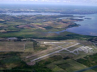
Canadian Forces Base Trenton, formerly RCAF Station Trenton, is a Canadian Forces base located within the city of Quinte West, Ontario. It is operated as an air force base by the Royal Canadian Air Force (RCAF) and is the hub for air transport operations in Canada and abroad. Its primary RCAF lodger unit is 8 Wing, commonly referred to as 8 Wing Trenton. CFB Trenton is Canada's largest Air Force base.

Tyendinaga (Mohawk) Airport is a registered aerodrome that is open to the public and caters mainly to general aviation. The aerodrome is located in Tyendinaga Mohawk Territory, 3 nautical miles southwest of Tyendinaga, Ontario, Canada, north of the Bay of Quinte between Kingston and Belleville.
Trenton/Mountain View Airport is located 5.2 nautical miles southeast of Mountain View, Ontario, Canada.
Canadian Forces Detachment Dundurn is a Canadian Forces facility located near the town of Dundurn, Saskatchewan and approximately 40 km south of Saskatoon, Saskatchewan along the east bank of Brightwater Creek.

Canadian Forces Detachment Mountain View, also CFD Mountain View, is a Canadian Forces airfield located in Prince Edward County, Ontario, south of Belleville. It is geographically close to CFB Trenton, which has administrative responsibility for the facilities.
Carrying Place is a community that serves as the gateway to Prince Edward County, Ontario, Canada. Situated northwest of Picton and just south of Trenton, it was named for its location on the portage between the Bay of Quinte and Weller's Bay on Lake Ontario. The Loyalist Parkway passes through the community.
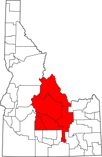
Central Idaho is a geographical term for the region located northeast of Boise and southeast of Lewiston in the U.S. state of Idaho. It is dominated by federal lands administered by the United States Forest Service and the Bureau of Land Management. Idaho's tallest mountain, Borah Peak, is located in this region. A large part of the Sawtooth National Recreation Area is within Central Idaho.
Canadian Forces Base Picton was a military installation located in Picton, Ontario. The base was active from the Second World War to 1969 and served the Royal Air Force, Royal Canadian Air Force and Canadian Army. Today, the site functions as the Picton Airport.

Chitaraque is a town and municipality in the Ricaurte Province, part of the Colombian department of Boyacá. The urban centre is located at a distance of 104.6 kilometres (65.0 mi) from the department capital Tunja and situated at an altitude of 1,575 metres (5,167 ft) in the Eastern Ranges of the Colombian Andes. It borders Gámbita, Santander in the east and south, San José de Pare, Santana and Togüí in the west and Suaita, Santander in the north.
Rebholz Nunatak is an isolated nunatak just north of the Hudson Mountains, located 8 nautical miles (15 km) north-northwest of Teeters Nunatak. Mapped by United States Geological Survey (USGS) from ground surveys and U.S. Navy air photos, 1960–66. Named by Advisory Committee on Antarctic Names (US-ACAN) for Maj. Edward Rebholz, operations officer of the U.S. Army Aviation Detachment which supported the Ellsworth Land Survey, 1968–69.

Hastings-Quinte Paramedic Service is a rural ambulance service for Member Municipalities of Hastings County, including the Cities of Belleville and Quinte West, and also under contract to the Prince Edward County

Wellers Bay is a small bay on Lake Ontario. In 1861 the Government of the Province of Canada considered making it a "harbour of refuge", and installing a lighthouse.
State Route 367, also known as College Street, is a short 4.80-mile-long (7.72 km) north-south state highway located entirely in the city of Trenton, Tennessee.
