Artemivsk is a city in Perevalsk Raion of Luhansk Oblast in eastern Ukraine. Population: 7,506 (2013 est.).

Mukh Kampul District is a district (srok) of Kandal Province, Cambodia. The district is subdivided into 9 communes (khum) such as Bak Khaeng, Kaoh Dach, Preaek Anhchanh, Preaek Dambang ,Roka Kaong Muoy,Roka Kaong Pir, Ruessei Chrouy, Sambuor Meas, Svay Ampear and 47 villages (phum).

Wadazuka Station is a railway station on the Enoshima Electric Railway (Enoden) located in Kamakura, Kanagawa Prefecture, Japan. It is 9.2 kilometers from the terminus of the Enoden at Fujisawa Station.

La Treille is a quartier on the outskirts of the 11th arrondissement of Marseille, in the Department of Bouches-du-Rhône, France. It has approximately 900 inhabitants. At the centre of the quartier is the seventeenth century hillside village of La Treille.
Kąciki is a village in the administrative district of Gmina Jedwabne, within Łomża County, Podlaskie Voivodeship, in north-eastern Poland.
Zofijówka is a village in the administrative district of Gmina Wojcieszków, within Łuków County, Lublin Voivodeship, in eastern Poland.

Szopinek is a village in the administrative district of Gmina Zamość, within Zamość County, Lublin Voivodeship, in eastern Poland. It lies approximately 4 kilometres (2 mi) east of Zamość and 79 km (49 mi) south-east of the regional capital Lublin.
Gęsice is a village in the administrative district of Gmina Łagów, within Kielce County, Świętokrzyskie Voivodeship, in south-central Poland. It lies approximately 5 kilometres (3 mi) south-east of Łagów and 38 km (24 mi) south-east of the regional capital Kielce.
Łąki is a village in the administrative district of Gmina Górzno, within Garwolin County, Masovian Voivodeship, in east-central Poland. It lies approximately 3 kilometres (2 mi) north-east of Górzno, 9 km (6 mi) south-east of Garwolin, and 65 km (40 mi) south-east of Warsaw.
Grabina is a village in the administrative district of Gmina Halinów, within Mińsk County, Masovian Voivodeship, in east-central Poland. It lies approximately 3 kilometres (2 mi) west of Halinów, 19 km (12 mi) west of Mińsk Mazowiecki, and 22 km (14 mi) east of Warsaw.
Leżnice is a village in the administrative district of Gmina Pasłęk, within Elbląg County, Warmian-Masurian Voivodeship, in northern Poland. It lies approximately 6 kilometres (4 mi) east of Pasłęk, 23 km (14 mi) east of Elbląg, and 59 km (37 mi) north-west of the regional capital Olsztyn.
Pasternak is a village in the administrative district of Gmina Węgorzewo, within Węgorzewo County, Warmian-Masurian Voivodeship, in northern Poland, close to the border with the Kaliningrad Oblast of Russia.
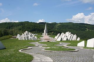
Kadinjača is a village, fourteen kilometers from the city of Užice, Serbia, on the route of the highway Užice - Bajina Bašta. It is famous for its memorial of Kadinjača.
North City is a neighborhood within the city of Shoreline, Washington, United States, located north of Seattle. The neighborhood is centered at 15th Avenue N.E. and N.E 175th Street.

Rudare is a village in the municipality of Kuršumlija, Serbia. According to the 2002 census, the village has a population of 246 people.

Hrančići is a village in the municipality of Goražde, Bosnia and Herzegovina.

Panga is a village in Saaremaa Parish, Saare County in western Estonia.
Mramorsko Brdo is a village situated in Merošina municipality in Serbia.
Razgari is a village in Lahijan-e Gharbi Rural District, Lajan District, Piranshahr County, West Azerbaijan Province, Iran. At the 2006 census, its population was 912, in 181 families.
Brushy Creek is a stream in eastern Taney County in the Ozarks of southern Missouri.


