Lan Xang or Lancang was a Lao kingdom that held the area of present-day Laos from 1353 to 1707. For three and a half centuries, Lan Xang was one of the largest kingdoms in Southeast Asia. The kingdom is the basis for Laos's national historic and cultural identity.

Luang Phabang, or Louangphabang, commonly transliterated into Western languages from the pre-1975 Lao spelling ຫຼວງພຣະບາງ as Luang Prabang, literally meaning "Royal Buddha Image", is a city in north central Laos, consisting of 58 adjacent villages, of which 33 comprise the UNESCO Town Of Luang Prabang World Heritage Site. It was listed in 1995 for unique and "remarkably" well preserved architectural, religious and cultural heritage, a blend of the rural and urban developments over several centuries, including the French colonial influences during the 19th and 20th centuries.

Vang Vieng is a tourist-oriented town in Laos in Vientiane Province which takes about two hours through bus from the national capital Vientiane. The town lies on the Nam Song River. The most notable feature of the area is the karst topography surrounding the town.
Lahu is a Tibeto-Burman language spoken by the Lahu people of China, Thailand, Myanmar, Vietnam and Laos. It is widely used in China, both by Lahu people, and by other ethnic minorities in Yunnan, who use it as a lingua franca. However, the language is not widely used nor taught in any schools in Thailand, where many Lahu are in fact refugees and illegal immigrants, having crossed into Thailand from Myanmar.

Muang Sing is a small town and district (muang) in Luang Namtha Province, northwestern Laos, about 60 kilometres northwest of the town of Luang Namtha and 360 kilometres northwest of Vientiane. It lies very close to the border with Yunnan, China, surrounded by mountains and rivers. Historically, Muang Sing has been a major producer of opium and still has problems with drugs and smuggling, due to its proximity to China and Myanmar.
Ban Pakpo, also Pak Pok or Pakpo, is a village in Vientiane Province, Laos. It is located north along Route 13 from Vang Vieng, not far from the eastern bank of the Nam Song River. To the northwest of the village is the Tham Pha Thao cave and the Tham Sang Triangle of four caves.
Ban Pha Tang or Ban Phatang is a small town in Vientiane Province, Laos. It is located 10.2 kilometres (6.3 mi) north along Route 13 from Vang Vieng, north of Ban Pakpo, on the bank of the Nam Song River. From Ban Pha Tang, the road climbs steeply to Ban Phahom, Ban Thieng and Muang Kasi. Lonely Planet describes it as a "pretty riverside village named after Pha Tang, a towering limestone cliff. The town's bridge offers a very photogenic view of its namesake." Phatang Resort lies to the south of the settlement.
Tham Phu Kham is a cave to the northwest of Vang Vieng, Laos, located just to the northeast of the village of Ban Na Thong. Its name means "Blue Lagoon" due to its blue waters. The cave is revered by the locals and contains several Buddha images. The largest is a reclining bronze Thai Buddha in the main cave.
Ban Kenpha is a village in Houaphanh Province, northeastern Laos. It is to the northeast of Vieng Kham, not far from Muang Xon.

Attapeu is a province of Laos in the southeast of the country. It has five districts: Samakkixay, Xaysetha, Sanamxay, Sanxay, and Phouvong, covering an area of 10,320 square kilometres (3,980 sq mi) with a population of 127,285. Its capital city lies at Attapeu.

Vientiane province is a province of Laos in the country's northwest. As of 2015 the province had a population of 419,090. Vientiane province covers an area of 15,610 square kilometres (6,030 sq mi) composed of 11 districts. The principal towns are Vang Vieng and Muang Phôn-Hông.

Xiangkhouang is a province of Laos on the Xiangkhoang Plateau, in the nation's northeast. The province has the distinction of being the most heavily bombed place on Earth.

Houaphanh province is a province in eastern Laos. Its capital is Xam Neua.

Savannakhet is a province of Laos. The name derives from Savanh Nakhone the province's original name. It bears the same meaning as Nakhon Sawan, a city in Thailand.

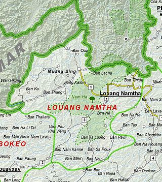
Luang Namtha is a province of Laos in the country's north. From 1966 to 1976 it formed, together with Bokeo, the province of Houakhong. Luang Namtha province covers an area of 9,325 square kilometres (3,600 sq mi). Its provincial capital is Luang Namtha. The province borders Yunnan, China to the north, Oudomxai province to the east and southeast, Bokeo province to the southwest, and Shan State, Myanmar to the northwest.

Vientiane is a prefecture of Laos, in the northwest Laos. The national capital, Vientiane, is in the prefecture. The prefecture was created in 1989, when it was split off from Vientiane province.

Oudomxay is a province of Laos, located in the northwest of the country. Its capital is Muang Xai.

Muang Soui(In Lao: ເມືອງສຸຍ) is a small town in Xiangkhouang Province Laos. It is located on Route 7 of Laos, so east of Phoukhoune district, northwest of Phonsavan, and Ban Phou Pheung Noi, but north of Sam Thong, and Long Tieng.

The Vientiane–Boten Expressway is a partially completed expressway between Boten, on the China–Laos border, and Vientiane, the capital of Laos. It roughly parallels Route 13.

Route 7 of Laos, ເສັ້ນ ທາງ ເລກ 7 ຂອງປະເທດລາວ (ທ. 7) is a provincial road served from east to west in Xiangkhouang province, Laos. It runs from Nong Het in the east to Phoukhoune District in the west. This is where people change connections to go to Luang prabang or Vientiane.


