
The geography of Mozambique consists mostly of coastal lowlands with uplands in its center and high plateaus in the northwest. There are also mountains in the western portion. The country is located on the east coast of southern Africa, directly west of the island of Madagascar. Mozambique has a tropical climate with two seasons, a wet season from October to March and a dry season from April to September.

The Eastern Highlands, also known as the Manica Highlands, is a mountain range on the border of Zimbabwe and Mozambique. The Eastern Highlands extend north and south for about 300 kilometres (190 mi) through Zimbabwe's Manicaland Province and Mozambique's Manica Province.

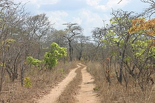
The Miombo woodland is a tropical and subtropical grasslands, savannas, and shrublands biome. It includes four woodland savanna ecoregions characterized by the dominant presence of Brachystegia and Julbernardia species of trees, and has a range of climates ranging from humid to semi-arid, and tropical to subtropical or even temperate. The trees characteristically shed their leaves for a short period in the dry season to reduce water loss, and produce a flush of new leaves just before the onset of the rainy season with rich gold and red colours masking the underlying chlorophyll, reminiscent of temperate autumn colours in the temperate zone.
The Makonde are an ethnic group in southeast Tanzania, northern Mozambique, and Kenya. The Makonde developed their culture on the Mueda Plateau in Mozambique. At present they live throughout Tanzania and Mozambique, and have a small presence in Kenya. The Makonde population in Tanzania was estimated in 2001 to be 1,140,000, and the 1997 census in Mozambique put the Makonde population in that country at 233,358, for an estimated total of 1,373,358. The ethnic group is roughly divided by the Ruvuma River; members of the group in Tanzania are referred to as the Makonde, and those in Mozambique as the Maconde. The two groups have developed separate languages over time but share a common origin and culture.

The Eastern miombo woodlands (AT0706) are an ecoregion of grassland and woodland in northern Mozambique, southern Tanzania, and southeastern Malawi.

The wildlife of Mozambique consists of the flora and fauna of this country in southeastern Africa. Mozambique has a range of different habitat types and an ecologically rich and diverse wildlife. This includes 236 species of mammal, 740 species of bird and 5,692 species of vascular plant. The Maputaland-Pondoland-Albany hotspot, with significantly high levels of biodiversity, stretches from the southern tip of Mozambique into northeastern South Africa.
The biomes and ecoregions in the ecology of Zambia are described, listed and mapped here, following the World Wildlife Fund's classification scheme for terrestrial ecoregions, and the WWF freshwater ecoregion classification for rivers, lakes and wetlands. Zambia is in the Zambezian region of the Afrotropical biogeographic realm. Three terrestrial biomes are well represented in the country . The distribution of the biomes and ecoregions is governed mainly by the physical environment, especially climate.

The Southern Zanzibar-Inhambane coastal forest mosaic, also known as the Southern Swahili coastal forests and woodlands, is a tropical moist broadleaf forest ecoregion of eastern Africa. It is a southern variation of Northern Zanzibar-Inhambane coastal forest mosaic. The ecoregion supports habitats of forest, savanna and swamps. The southern portion of the ecoregion is not as well studied due to the 1977-1992 civil war in Mozambique.

The Victoria Plains tropical savanna is a tropical and subtropical grasslands, savannas, and shrublands ecoregion in northwestern Australia.
The Southern Highlands is a highland region in southwestern Tanzania, at the northern end of Lake Malawi. The highlands include portions of Mbeya, Njombe, Rukwa, Ruvuma, and Songwe regions, bordering Malawi, Mozambique, and Zambia. Mbeya is the largest city in the highlands.
The Lukuledi is a river in The United Republic Of Tanzania, south-eastern region of Africa. With a total length of 160 km, it rises from the boundary between the Lindi and Mtwara regions.

The Zambezian and mopane woodlands is a tropical and subtropical grasslands, savannas, and shrublands ecoregion of southeastern Africa.

The Rondo Plateau, also known as the Muera Plateau, is a high and extensive massif in the Lindi Region and northern Mtwara Region of southeastern of Tanzania. A portion of the plateau is protected by the Rondo Forest Reserve. It is one of a group of dissected plateaus lying between the Mbwemburu and Lukuledi rivers. It is approximately 60 km inland from Lindi, and is situated 15 km north of the Masasi road. It was revealed as an important biodiversity site in studies conducted since the 1980s.

Mount Chiperone is a mountain in northern Mozambique.
The Makonde Plateau, also known as the Newala Plateau, is a plateau in southeastern Tanzania. It is mostly within Mtwara Region, with the northeast corner in Lindi Region.
The Cheringoma Plateau is a low plateau in Sofala Province of Mozambique. It lies mostly within Cheringoma, Muanza, and Marromeu districts.

The Rubeho Mountains are a mountain range in central Tanzania. The mountains in Dodoma and Morogoro regions, southeast of Tanzania's capital Dodoma. The Rubeho Mountains are part of the Eastern Arc Mountains, and are home to a biodiverse community of flora and fauna with large numbers of endemic species.
The Southern miombo woodlands is a tropical grasslands and woodlands ecoregion extending across portions of Malawi, Mozambique, Zambia, and Zimbabwe.
The Zambezian region is a large biogeographical region in Africa. The Zambezian region includes woodlands, savannas, grasslands, and thickets, extending from east to west in a broad belt across the continent. The Zambezian region lies south of the rainforests of the Guineo-Congolian region. The Zambezian region is bounded by deserts and xeric shrublands on the southwest, the Highveld grasslands of South Africa to the south, and the subtropical Maputaland forests on the southeast.
