Muffin Islands

Last updated

Muffin Islands is an island in Wrangell, Alaska, in the United States. [1] The islands lie at the entrance of Ernest Sound. [2]

Wrangell, Alaska Unified Borough in Alaska, United States

The City and Borough of Wrangell is a borough in Alaska, United States. As of the 2010 census the population was 2,369, up from 2,308 in 2000. Incorporated as a Unified Home Rule Borough on May 30, 2008, Wrangell was previously a city in the Wrangell-Petersburg Census Area. Its Tlingit name is Ḵaachx̱aana.áakʼw. The Tlingit people residing in the Wrangell area, who were there centuries before Europeans, call themselves the Shtaxʼhéen Ḵwáan after the nearby Stikine River. Alternately they use the autonym Shxʼát Ḵwáan, where the meaning of shxʼát is unknown.

United States Federal republic in North America

The United States of America (USA), commonly known as the United States or America, is a country comprising 50 states, a federal district, five major self-governing territories, and various possessions. At 3.8 million square miles, the United States is the world's third or fourth largest country by total area and is slightly smaller than the entire continent of Europe's 3.9 million square miles. With a population of over 327 million people, the U.S. is the third most populous country. The capital is Washington, D.C., and the largest city by population is New York City. Forty-eight states and the capital's federal district are contiguous in North America between Canada and Mexico. The State of Alaska is in the northwest corner of North America, bordered by Canada to the east and across the Bering Strait from Russia to the west. The State of Hawaii is an archipelago in the mid-Pacific Ocean. The U.S. territories are scattered about the Pacific Ocean and the Caribbean Sea, stretching across nine official time zones. The extremely diverse geography, climate, and wildlife of the United States make it one of the world's 17 megadiverse countries.

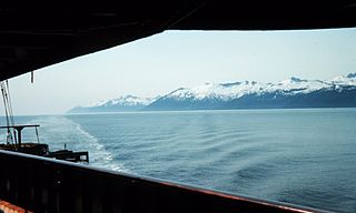
Ernest Sound is a strait in Southeast Alaska, U.S.A. It extends 48 kilometres (30 mi) southwest, from the mouth of Bradfield Canal to Clarence Strait, separating Wrangell and Etolin Islands from the mainland. It was first traversed and charted in 1793 by James Johnstone, one of George Vancouver's officers during his 1791-95 expedition. Vancouver later named it "Prince Ernest's Sound", after Prince Ernest, Duke of Cumberland.

Muffin Islands has been noted for its unusual place name. [3]

Place names considered unusual Wikimedia list article

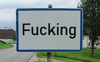
Unusual place names are names for cities, towns, and other regions which are considered non-ordinary in some manner. This can include place names which are also swear words, inadvertently humorous or highly charged words, as well as place names of unorthodox spelling and pronunciation, including especially short or long names.

Related Research Articles

Butterfield Township, Michigan Township in Michigan, United States

Butterfield Township is a civil township of Missaukee County in the U.S. state of Michigan. As of the 2000 census, the township population was 548.

Clarence Strait

Clarence Strait, originally Duke of Clarence Strait, is a strait in southeastern Alaska, in the United States in the Alexander Archipelago. The strait separates Prince of Wales Island, on the west side, from Revillagigedo Island and Annette Island, on the east side. Clarence Strait is 126 miles (203 km) long, extending from Dixon Entrance to Sumner Strait. Moira Sound is on the west side of the strait.

Alger Island, New York island in the United States of America

Alger Island, also known as Big Island, is a small island located on Fourth Lake, part of the Fulton Chain of Lakes, within the Adirondack Park in New York State. The island is located in the Town of Webb, in Herkimer County, New York.

Petit Bois Island (Mississippi) island in the United States of America

Petit Bois Island is an island off the coast of the U.S. state of Mississippi, south of Pascagoula. It is part of Jackson County, Mississippi. Since 1971 it has been a part of Gulf Islands National Seashore, administered by the U.S. National Park Service.

The Craig River is a river located in Alaska, United States and British Columbia, Canada, also formerly known as the South Fork of the Iskut River, as it is the main south tributary of the lower Iskut. The Craig has a tributary in Alaska, the South Fork Craig River. The river's origin in Alaska is located near 56°27′00″N131°25′00″W and crosses into British Columbia at 56°29′30″N131°17′30″W.

Snowshoe Springs, California Unincorporated community in California, United States

Snowshoe Springs is an unincorporated community in Calaveras County, California. It lies at an elevation of 4885 feet.

Patrick Creek, California Unincorporated community in California, United States

Patrick Creek is an unincorporated community in Del Norte County, California. It is located 7 miles (11 km) east-northeast Gasquet, at an elevation of 843 feet.

Horizon High School is a public high school for school-age mothers located in Pleasanton, California, a community in the San Francisco Bay Area. Horizon is a part of the Pleasanton Unified School District, which also includes Amador Valley High School, Foothill High School, and Village High School.

Bis Ii Ah Wash is a stream located in Apache County, Arizona, southwest of the census-designated place of Nazlini. The name was collected by the United States Geological Survey between 1976 and 1980, and entered into the Geographic Names Information System on February 8, 1980.

Angle Creek is a stream in Lake and Peninsula Borough, Alaska, in the United States.

Johns Creek is a stream in Jackson County, in the U.S. state of North Carolina.

Lake Lillian is a lake in Kandiyohi County, in the U.S. state of Minnesota.

Troublesome, Colorado human settlement in Colorado, United States of America

Troublesome is an unincorporated community in Grand County, in the U.S. state of Colorado.

Long is an unincorporated community in Columbia County, in the U.S. state of Washington. An early variant name was Milton Mills.

Strain is an unincorporated community in Franklin County, in the U.S. state of Missouri.

Ingram Ridge is an unincorporated community in Pemiscot County, in the U.S. state of Missouri.

Belfast is an unincorporated community in Bryan County, Georgia, United States. It is part of Savannah–Hinesville–Statesboro Combined Statistical Area.

Adabelle is an unincorporated community in Bulloch County, in the U.S. state of Georgia.

References

  1. U.S. Geological Survey Geographic Names Information System: Muffin Islands
  2. Bulletin of the United States Geological Survey. U.S. Government Printing Office. 1902. p. 291.
  3. Kolpas, Norman (14 March 2005). Practically Useless Information on Food and Drink. Thomas Nelson Inc. p. 99. ISBN   978-1-4185-5389-0.

Coordinates: 55°52′30″N132°17′30″W / 55.87500°N 132.29167°W / 55.87500; -132.29167

Geographic coordinate system Coordinate system

A geographic coordinate system is a coordinate system that enables every location on Earth to be specified by a set of numbers, letters or symbols. The coordinates are often chosen such that one of the numbers represents a vertical position and two or three of the numbers represent a horizontal position; alternatively, a geographic position may be expressed in a combined three-dimensional Cartesian vector. A common choice of coordinates is latitude, longitude and elevation. To specify a location on a plane requires a map projection.