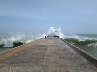
Muhilankudieruppu is a village located in AgasteeswaramTaluk, Kanyakumari District, Tamil Nadu, India. Located 4km from Kanyakumari and 16km from Nagercoil (capital town of Kanyakumari on the road connecting Kanyakumari with Nagercoil and nearest city Trivandrum (Kerala). The village is surrounded by paddy fields, coconut groves, element enriched and beautiful sea shore (Arabian Sea). Further, this village has a pleasant climate throughout the year and benefited by both north east and south west monsoons. Muhilai is divided into two parts, West Muhilai (mela) and East Muhilai (keezha). Keezha muhilai people worship Hindu Goddess Devi Mutharamman and mela muhilai people worship the Swamy Sriman Ayya Narayanaswamy. Nearly two thousand people live here and most of the people are well-educated; some work as doctors, engineers, scientists all over the world. Muhilankudieruppu has an average literacy rate of 94%, far higher than the national average of 59.5%: male literacy is 97%, and female literacy is 91%. The Holy place of Swamythoppu pathy (Ayyavazhi) is located near Muhilankudierrupu, 4km away.
Kanyakumari district is the southernmost district in Tamil Nadu state and mainland India. It stands second in terms of population density among the districts of Tamil Nadu and next only to Chennai district. It is the richest district in Tamil Nadu in terms of per capita income, and also tops the state in Human Development Index (HDI), literacy and education. The district headquarters is Nagercoil.
Tamil Nadu, formerly Madras State, is one of the 29 states of India. Its capital and largest city is Chennai. Tamil Nadu lies in the southernmost part of the Indian subcontinent and is bordered by the union territory of Puducherry and the South Indian states of Kerala, Karnataka, and Andhra Pradesh. It is bounded by the Eastern Ghats on the north, by the Nilgiri Mountains, the Meghamalai Hills, and Kerala on the west, by the Bay of Bengal in the east, by the Gulf of Mannar and the Palk Strait on the southeast, and by the Indian Ocean on the south. The state shares a maritime border with the nation of Sri Lanka.
Nagercoil is a city in the southernmost Indian district of Kanyakumari in Tamil Nadu and a corporation. It is the administrative headquarters of Kanyakumari District in Tamil Nadu. The city, situated close to the tip of the Indian peninsula, lies in an undulating terrain between the Western Ghats and the Arabian Sea.
This page is based on this Wikipedia article Text is available under the CC BY-SA 4.0 license; additional terms may apply. Images, videos and audio are available under their respective licenses.
Related Research Articles
Padmanabhapuram is a town and a municipality near Thuckalay in Kanyakumari district in the Indian state of Tamil Nadu. As of 2011, the town had a population of 21,342.
Udangudi is a Panchayat town in Thoothukudi district in the Indian state of Tamil Nadu. It is a small village in Tamil Nadu, India situated near Thiruchendur. The village was once known for Vetrilai and Karuppatti.
Mutta Pathi, is one of the Pancha pathi, which are the primary centers for worship of the Ayyavazhi. This is the third important pilgrim center of Ayyavazhi. This place earn the religious importance in Akilam from the event that, Ayya Vaikundar is given two Vinchais here by Narayana under the Sea; One just before the arrest of Vaikundar by Swathi Thirunal and the second after the completion of Thuvayal Thavasu.
Thamaraikulam Pathi, is one among the Pancha pathi, the five holy places of Ayyavazhi. The Ari Gopalan Citar, who wrote the Akilam was born here.
Poo Pathi is one among the Pancha pathi, which are the primary worship centers and holy places of Ayyavazhi. As the incarnational activity of Vaikundar, the marriage with Poomadanthai, the Goddess of Earth was the event took place here. This Poomadanthai was the final deity unified by Vaikundar into himself, symbolizing the destruction of Kali from the world (earth).
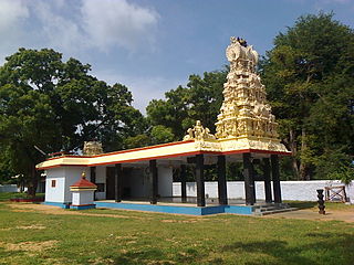
Pancha pathi are the five important pilgrim centers of Ayyavazhi. These are also considered as the primary Pathis and as worship centers of Ayyavazhi with primary status. The first pathi is Swamithope pathi itself and is the headquarters of Ayyavazhi. The other Pathis are Muttappathi, Thamaraikulam Pathi, Ambalappathi and Pooppathi.
Marungoor, also spelt Marungur, is a panchayat town near Suchindrum in Kanniyakumari district in the Indian state of Tamil Nadu. The place sprawls over an area of about 10 km².
Colachel is a coastal town in the far south of India, located within the administrative jurisdiction of Kanyakumari District. It is a natural harbor on the Malabar coast, located 20 km north-west of Kanyakumari, the southernmost tip of India. As of 2011, the town had a population of 47,007.
Avaraikulam is a village in Tirunelveli district of Tamil Nadu, India. It is located 72.5 km from Tirunelveli main town and 19.8 km from Kanyakumari. A village with 90% of people working for Agriculture directly or indirectly. A temple Arulmigu Mutharamman Thirukovil is in the middle of the Village and which is famous for its Vaigasi Thiruvizha. It has a school named Baliah Marthandam Memorial Higher Secondary School. The students from the surrounding villages are studying in Avaraikulam. Avaraikulam has many windmills to produce electricity from the wind.
Melpuram is a historical place in Kanyakumari district, Tamil Nadu, India.
Thirunanthikara is a village situated in Thirparappu panchayath, in the Kanyakumari district of Tamil Nadu, India. This village comes under the post office of Kulasekharam, 3 km away, and is located along the Kulasekharam–Pechipara road. The primary revenue source for the area is natural rubber production and tapping. Many of the youth of Thirunanthikara work in Gulf countries and their money helps support the village. 20% of the people speak Malayalam, 80% speak Tamil. The traditions and customs of the people are similar to those of the people of Kerala.
Kayamozhi is a village which is situated 9 km in west of Thiruchendur in Thoothukudi district, Tamil Nadu, India. The history of this Village goes back to the 16th century AD as a capital of the old vadapattu region.
Mangavilai is a village in Kanyakumari district of Tamil Nadu, India. Mangavilai comes under the Dharmapuram Panchayat, and is 9 km from Nagercoil, the district headquarters of Kanyakumari. The name Mangavilai means undestroyable fame.
Kombavilai is a village located in Agasteeswaram Taluk, Kanyakumari District, Tamil Nadu, India. The village is surrounded by paddy fields, coconut groves, element enriched and beautiful sea shore. Further, this village has a pleasant climate throughout the year and benefited by both north east and south west monsoons. The people are living harmoniously with religious diversity of worshiping Hindu Goddess Devi Mutharamman, Esakiamman, Swamy Sriman Ayya Narayanaswamy and Christians as minor population. Nearly two hundred people live here and most of the people are educated; kombavilai has an average literacy rate of 90%, far higher than the national average of 59.5%: male literacy is 91%, and female literacy is 89%. The Holy place of Swamythoppu pathy (Ayyavazhi) is located near Muhilankudierrupu, 7 km away
Swamithoppe Pathi is the primary pathi of the Ayyavazhi, the head of all Worship centers of Ayyavazhi, and the sacred venue of the Tavam. Religiously Swamithope is considered primary among the Pancha pathi and the primary centre of the incarnational activities of Vaikundar.
Thambithoppu is a small village located in the town of Kalakkad, Tamil Nadu, India.
Peyode is located near Nagercoil, a suburb of Kanyakumari in the Indian state of Tamil Nadu. It is a southern suburb of Kanyakumari city,located on Nagercoil-Colachel SH 46. Nearby places are Rajakamangalam,Vellichanthai and Muttom.
Vallan Kumaran Vilai is a village in Kanyakumari district, Tamil Nadu, India. It is situated about two kilometers from Nagercoil.
Keezha Sarakkalvilai is a small village in Kanniyakumari district in the Indian state of Tamil Nadu with Indian postal code as 629002. It is an important pilgrim and the site of the famous Bathirakali Amman Temple.