Related Research Articles

Tonga, officially named the Kingdom of Tonga, is a Polynesian country and archipelago comprising 169 islands, of which 36 are inhabited. The total surface area is about 750 square kilometres (290 sq mi) scattered over 700,000 square kilometres (270,000 sq mi) of the southern Pacific Ocean. As of 2016, the state had a population of 100,651 people, of whom 70% reside on the main island of Tongatapu.

The Tonga Trench is an oceanic trench located in the south-west Pacific Ocean. It is the deepest trench of the Southern Hemisphere and the second deepest on Earth. The fastest plate tectonic velocity on Earth occurs here, as the Pacific Plate is being subducted westward in the trench.

Tongatapu is the main island of the Kingdom of Tonga and the location of its capital Nukuʻalofa. It is located in Tonga's southern island group, to which it gives its name, and is the country's most populous island, with 74,611 residents (2016), 70.5% of the national population, on 260 square kilometres. Its maximum elevation is 65 metres above sea level. Tongatapu is Tonga's centre of government and the seat of its monarchy.

Haʻapai is a group of islands, islets, reefs and shoals with an area of 109.30 square kilometres (42.20 sq mi) in the central part of the Kingdom of Tonga, with the Tongatapu group to the south and the Vavaʻu group to the north. Seventeen of the Haʻapai islands are populated with altogether 6,125 people. Its highest point is Kao at almost 1,050 metres (3,440 ft).
Haʻafeva is a small island in the Haʻapai group of Tonga, but still the main island of the Lulunga archipelago. Kolongatata is the name commonly given to the village on Haʻafeva and is a reference to Haʻafeva's exposure to strong winds. The inhabited area of Haʻafeva can be divided into Hahake, Hihifo, Tuʻa Kolo, Loto Kolo and Uta. The Island has a population of about 200.

ʻEua is an island in the kingdom of Tonga. It is close to Tongatapu, but forms a separate administrative division. It has an area of 87.44 km2 (33.76 sq mi), and a population in 2016 of 4,945 people.
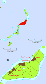
Foa is an island in Tonga. It is located within the Haʻapai group in the centre of the country, to northeast of the national capital of Nukuʻalofa.

Lifuka is an island in the Kingdom of Tonga. It is located within the Haʻapai Group in the centre of the country, to northeast of the national capital of Nukuʻalofa.
Lofanga is an island in Tonga. It is located within the Ha'apai Group in the centre of the country, to northeast of the national capital of Nukuʻalofa. The island had a population of 120 at 2011, and an area of 1.45 km².

The Battle of Kaba was fought at Kaba, Fiji, in 1855 between self proclaimed Fijian Tui Viti (King) Cakobau and his enemies from Rewa and Bau. In 1853, Cokobau had previously attempted to take the rebel positions at Kaba, in which he was brutally defeated. This time though Cakobau was supported by a strong fleet from Tonga, sent by Tu'i Tonga (King) Taufa'ahau of Tonga and Enele Ma'afu, governor of the Tongan population in Fiji. The battle was a major victory for Cakobau, thanks mainly to his Tongan allies, and cemented his leadership over Fiji. It also, however, underlined his dependency on the military power of Tonga, especially since Ma'afu remained in Fiji.
Haʻano is an island in the Haʻapai islands of Tonga. To the south are the islands of Foa and Lifuka.
Moʻungaʻone is an island in Lifuka district, in the Haʻapai islands of Tonga. It had a population of 136 and an area of 1.17 km2 (0.45 sq mi).
Fotuha'a is an island in Lifuka district, in the Haʻapai islands of Tonga. As of 2020, the population is estimated at approximately 100-150 and an area of 1.14 km².
ʻUiha is an island in Lifuka district, in the Haʻapai islands of Tonga. It had a population of 638 in 2006 and an area of 5.36 km2 (2.07 sq mi).
Kotu is an island in Lulunga district, in the Ha'apai islands of Tonga. As of 1992, there was one village on the island with a population of approximately 200 people.
Tu'anuku is a village on the western part of Vava'u, Tonga, with a population of approximately 300 since Aug 2015. It has several nicknames such as Toa-ko-Tavakefai'ana, Halapukepuke, Hala-siki-'o-Mata'aho and also Uini-e-Ngofe.
Pukotala is a settlement in Ha'ano island, Tonga. It has a population of 89.
'Eua Motu'a is a district of ʻEua division, Tonga.
'Eua Fo'ou is a district of ʻEua division, Tonga.
References
- ↑ "TONGA 2016 CENSUS OF POPULATION AND HOUSING VOLUME 1: BASIC TABLES AND ADMINISTRATIVE REPORT" (PDF). October 2017. p. 20. Retrieved 30 December 2020.
Coordinates: 19°39′07″S174°17′38″W / 19.652°S 174.294°W
| This Tongan location article is a stub. You can help Wikipedia by expanding it. |