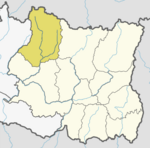
Solukhumbu District (Nepali: सोलुखुम्बु जिल्लाlisten , Sherpa: ཤར་ཁུམ་བུ་རྫོང་ཁ།, Wylie: shar khum bu dzong kha) is one of 14 districts of Province No. 1 of eastern Nepal. As the name suggests, it consists of the subregions Solu and Khumbu.
Bapha is a village development committee in Solukhumbu District in the Sagarmatha Zone of north-eastern Nepal. At the time of the 1991 Nepal census it had a population of 3,031 people living in 579 individual households.

Beni is a village development committee in Solukhumbu District in the Sagarmatha Zone of north-eastern Nepal. At the time of the 1991 Nepal census it had a population of 1927 people living in 352 individual households.
Tingla is a village development committee in Solukhumbu District in the Sagarmatha Zone of north-eastern Nepal. At the time of the 1991 Nepal census it had a population of 3,738 people living in 710 individual households.
Chaurikharka is a village development committee in Solukhumbu District in the Sagarmatha Zone of northeastern Nepal. At the time of the 1991 Nepal census it had a population of 2422 people living in 502 individual households.
Chheskam is a village development committee in Solukhumbu District in the Sagarmatha Zone of north-eastern Nepal. At the time of the 1991 Nepal census it had a population of 2824 people living in 641 individual households.
Deusa is a village development committee in Solukhumbu District in the Sagarmatha Zone of north-eastern Nepal. At the time of the 1991 Nepal census it had a population of 3835 people living in 747 individual households.
Goli is a village development committee in Solukhumbu District in the Sagarmatha Zone of north-eastern Nepal. At the time of the 1991 Nepal census it had a population of 2276 people living in 455 individual households.
Gorakhani is a village development committee in Solukhumbu District in the Sagarmatha Zone of north-eastern Nepal. At the time of the 1991 Nepal census it had a population of 1364 people living in 281 individual households.
Jubing was a village development committee in Solukhumbu District in the Sagarmatha Zone of north-eastern Nepal. It was divided and merged into two new formed Rural municipality in 2017 when the old administrative structures were reconstructed. Ward no. 2, 3, 4 and 6 were incorporated with Dudhkoshi rural municipality and remaining all wards 1, 5, 7, 8 and 9 were incorporated with Khumbu Pasanglhamu rural municipality.
Kaku, Nepal is a village development committee in Solukhumbu District in the Sagarmatha Zone of north-eastern Nepal. At the time of the 1991 Nepal census it had a population of 3896 people living in 750 individual households.
Kangel is a village development committee in Solukhumbu District in the Sagarmatha Zone of north-eastern Nepal. At the time of the 1991 Nepal census it had a population of 2087 people living in 416 individual households.
Kerung is a village development committee in Solukhumbu District in the Sagarmatha Zone of north-eastern Nepal. At the time of the 2011 Nepal census it had a population of 3602 people living in 873 individual households.
Lokhim is a village development committee, now it is officially changed thulung dhudkosika 09.Four major casts are living with their own believes and culture such as Lhosar, Tosi and local festivals are popular. Tamang, Rai,B.K and Sherpa are the major local people In this village. Slowly educational institutions as increasing yearly where are 5 schools are in operation phase. in Solukhumbu District in the Sagarmatha Zone of north-eastern Nepal. At the time of the 1991 Nepal census it had a population of 3098 people living in 585 individual households.
Taksindu is a village development committee in Solukhumbu District in the Sagarmatha Zone of north-eastern Nepal. At the time of the 1991 Nepal census it had a population of 2053 people living in 381 individual households.
Necha Batase is a village development committee in Solukhumbu District in the Sagarmatha Zone of north-eastern Nepal. At the time of the 1991 Nepal census it had a population of 3522 people living in 680 individual households.
Panchan, Nepal is a village development committee in Solukhumbu District in the Sagarmatha Zone of north-eastern Nepal. At the time of the 1991 Nepal census it had a population of 1698 people living in 318 individual households.

Salyan, Solukhumbu is a village development committee in Solukhumbu District in the Sagarmatha Zone of north-eastern Nepal. At the time of the 1991 Nepal census it had a population of 5307 people living in 1034 individual households. It has been merged into Necha Salyan Gaupalika.
Tapting is a village development committee in Solukhumbu District in the Sagarmatha Zone of north-eastern Nepal. At the time of the 1991 Nepal census it had a population of 2016 people living in 339 individual households. According to recent population research data in 2015,the population of Tapting VDC is 7580,living in 4850 individual households. Transportation--> = High Way Road is Connected from Capital Kathmandu to Tapting VDC.

Thulung Dudhkoshi is a rural municipality (gaunpalika) out of seven rural municipality located in Solukhumbu District of Province No. 1 of Nepal. There are a total of 8 municipalities in Solukhumbu in which 1 is urban and 7 are rural.