Mukwe Constituency

Last updated
Location of Mukwe constituency in the Kavango Region Wahlkreis Mukwe in Kavango.png
Location of Mukwe constituency in the Kavango Region

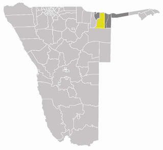
Mukwe is a constituency in the Kavango East region of Namibia. It has 26.000 inhabitants, [1] the district centre is the settlement of Mukwe.

Kavango East Region in Namibia

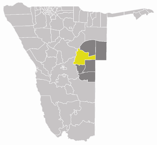
Kavango East is one of the fourteen regions of Namibia. Its capital is Rundu. Because of its rather higher rainfall than most other parts of Namibia, this region has agricultural potential for the cultivation of a variety of crops, as well as for organised forestry and agro-forestry, which stimulates furniture making and related industries.

Namibia republic in southern Africa

Namibia, officially the Republic of Namibia, is a country in southern Africa. Its western border is the Atlantic Ocean; it shares land borders with Zambia and Angola to the north, Botswana to the east and South Africa to the south and east. Although it does not border Zimbabwe, less than 200 metres of the Zambezi River separates the two countries. Namibia gained independence from South Africa on 21 March 1990, following the Namibian War of Independence. Its capital and largest city is Windhoek, and it is a member state of the United Nations (UN), the Southern African Development Community (SADC), the African Union (AU), and the Commonwealth of Nations.

Contents

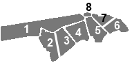
The constituency contains the major settlements of Bagani, Kangongo and Divundu, and a number of small populated places such as Andara and Diyogha.

Bagani, Namibia Settlement in Kavango East, Namibia

Bagani is a settlement on the south-western banks of the Okavango River in the Kavango East Region, Namibia, 200 kilometres (120 mi) east of Rundu and near the Popa Falls on the Okavango River. Bagani has a population of around 2.000 inhabitants and is homestead of the local Mbukushu kings.

Kangongo, Namibia Settlement in Kavango East, Namibia

Kangongo is a settlement on the Eastern banks of the Okavango River in the Kavango East Region, Namibia, 140 km east of Rundu along the Trans-Caprivi Highway. Kangongo has a population of around 3500 inhabitants.

Divundu Village in Kavango East, Namibia

Divundu is a village on the south-eastern banks of the Okavango River in the Kavango East Region, Namibia, 200 kilometres (120 mi) east of Rundu. Divundu has a population of around 5,430 inhabitants and is homestead of the local Mbukushu kings.

There is a bilateral agreement with Angola to allow mutual near-border immigration without travel documents. This applies to a maximum distance of 30 km, it is not valid for tourists.[ citation needed ]

Angola Country in Africa

Angola, officially the Republic of Angola, is a west-coast country of south-central Africa. It is the seventh-largest country in Africa, bordered by Namibia to the south, the Democratic Republic of the Congo to the north, Zambia to the east, and the Atlantic Ocean to the west. Angola has an exclave province, the province of Cabinda that borders the Republic of the Congo and the Democratic Republic of the Congo. The capital and largest city of Angola is Luanda.

Elections

2009

The day after the 2009 general election, the Electoral Commission of Namibia (ECN) called for a recount of Mukwe's ballots "after several political parties expressed their unhappiness over the counting process". [2] There were 19 polling stations in the constituency. In the certified results, incumbent President and SWAPO candidate Hifikepunye Pohamba received 6,227 votes of the 8,542 accepted votes. The closest candidates to Pohamba were Ignatius Shixwameni of the All People's Party (APP, 661 votes) and Hidipo Hamutenya of the Rally for Democracy and Progress (RDP, 343 votes). [3]

The Electoral Commission of Namibia (ECN) is an agency of the Government of Namibia. It was founded in 1992 under the Electoral Act #24 of 1992. The aim of the commission is to oversee all electoral activities starting from voter registration and political party registration, to the setting and monitoring of elections, counting of ballots and making results available.

SWAPO Political party in Namibia

The South West Africa People’s Organisation (SWAPO), officially known as SWAPO Party of Namibia, is a political party and former independence movement in Namibia. It has been the governing party in Namibia since the country achieved independence in 1990. The party continues to be dominated in number and influence by the Ovambo ethnic group.

Hifikepunye Pohamba 2nd president of Namibia

Hifikepunye Lucas Pohamba is a Namibian politician who served as the second President of Namibia from 21 March 2005 to 21 March 2015. He won the 2004 election overwhelmingly as the candidate of SWAPO, the ruling party, and was reelected in 2009. Pohamba was the president of SWAPO from 2007 until his retirement in 2015. He is a recipient of the Ibrahim Prize.

2010

In the 2010 local and regional elections, SWAPO's Christian Muriki won a seat in the Kavango Regional Council with 3,774 votes over APP's Pankratius Kutenda with 783 votes. Petrus Dishara of the Democratic Turnhalle Alliance (DTA) finished in third place with 414 votes and RDP's Justina Ngombara finished in last place 117 votes. [4]

2015

The 2015 regional elections were again a landslide win for Swapo. Johannes John Haushiku Thighuru received 5,541 votes while Venantius Kambogho of the APP received 484 votes and Bernand Thimbonde of the DTA came third with 442 votes. [5]

Related Research Articles

Kavango Region Former Region in Namibia

Kavango was one of the thirteen regions of Namibia until it was split into the Kavango East and Kavango West Regions in 2013. Its capital was Rundu.

Katima Mulilo Urban constituency of Namibia

Katima Mulilo Urban is a constituency in the Zambezi Region of Namibia, covering the capital city of the region, Katima Mulilo. As of 2004, the Constituency had 10,778 registered voters.

Katima Mulilo Rural constituency of Namibia

Katima Mulilo Rural is a constituency in the Zambezi Region of Namibia. Its population is 22,197. It comprises the area south of the city of Katima Mulilo, the regional capital.

Keetmanshoop Rural Electoral constituency of Namibia

Keetmanshoop Rural is an electoral constituency in the ǁKaras Region of Namibia. It contains the Krönlein suburb of Keetmanshoop and the villages of Koës and Aroab, the settlements of Seeheim and Klein Karas, as well as several farming communities in the area. The constituency office is situated in Aroab.

Rehoboth Rural is a constituency in the Hardap region of Namibia. It has a population of 7365. Among the settlements in Rehoboth Rural are Klein Aub, Khauxas, and Schlip.

2009 Namibian general election election

A presidential and parliamentary election was held on 27–28 November 2009 in Namibia. It was the fourth general election since independence and the fifth democratic election. Voting ended on 28 November and official election results, released on 4 December, showed that Hifikepunye Pohamba and his SWAPO Party were re-elected, each with over 75% of the vote. Prior to the election, the South West Africa People's Organization (SWAPO) was widely expected to score a landslide victory, with the Rally for Democracy and Progress (RDP) considered SWAPO's biggest challenger. Fourteen political parties competed for seats in the National Assembly of Namibia, and twelve candidates ran for the Presidency.

Sesfontein Constituency

Sesfontein Constituency is an electoral constituency of Namibia. Located in Kunene Region, it has a population of 7,358. Its district capital is the settlement of Sesfontein. It is bordered by Khorixas Constituency to the south, Kamanjab Constituency to the east, Opuwo Rural to the north and Okahao Constituency in Omusati Region to the northeast.

Kalahari Constituency

Kalahari Constituency is an electoral constituency in Omaheke Region, Namibia. It has 9,234 inhabitants, the constituency office has been inaugurated in 2009 and is located at the Ben-Hur settlement. The constituency forms part of the border between Namibia and Botswana.

Mpungu Constituency

Mpungu is a constituency in the Kavango West region of Namibia. Its population is 18,332. Nkurenkuru, the capital of Kavango West, is situated in this constituency. The Mpungu settlement is also located here.

Mashare Constituency

Mashare is a constituency in the Kavango East region of Namibia. It has 15,829 inhabitants, the district centre is the settlement of Mashare.

Kapako Constituency

Kapako is a constituency in the Kavango West region of Namibia. It has 25,653 inhabitants, the district centre is the settlement of Kapako.

Ondobe is a constituency in the Ohangwena Region of Namibia. It has 32,726 inhabitants, the district centre is the settlement of Ondobe.

Okorukambe Constituency constituency of Namibia

Okorukambe Constituency, until 2013 Steinhausen Constituency, is an electoral constituency in the Omaheke Region of Namibia. It has 9,066 inhabitants. Its district capital is the settlement of Steinhausen. It further contains the settlements of Witvlei and Omitara.

Tsumkwe Constituency

Tsumkwe Constituency is an electoral constituency in the Otjozondjupa Region of Namibia. It has 8,823 inhabitants and consists of the settlement of Tsumkwe and the surrounding rural area.

Rundu Rural West is an electoral constituency in the Kavango East Region of Namibia. It is located west of Rundu, one of Namibia's largest cities. Kasote and Sauyemwa are settlements in the constituency. Sauyemwea is an informal settlement located 5 kilometres (3.1 mi) from Rundu, and Kasote is 7 kilometres (4.3 mi) away from Rundu, both towards the west. Most of the residents of the constituency live in informal housing, which includes housing made of bricks or corrugated iron.

Rundu Urban is a political constituency in the Kavango East region of Namibia. It covers the urban area of Rundu, one of Namibia's largest cities. The constituency also covers parts of the Sauyemwa, Safari, Tutungeni, Katutura, Donkerhoek and Kehemu neighborhoods.

Opuwo Rural

Opuwo Rural is an electoral constituency in the Kunene Region of Namibia. It was created in August 2013, following a recommendation of the Fourth Delimitation Commission of Namibia, and in preparation of the 2014 general election. The administrative centre of Opuwo Rural is the settlement of Otuani.

Oshikunde Constituency is an electoral constituency in the Ohangwena Region of Namibia. It was created in August 2013, following a recommendation of the Fourth Delimitation Commission of Namibia, and in preparation of the 2014 general election. The administrative centre of Oshikunde Constituency is the settlement of Omutwewomunu.

Karasburg West is an electoral constituency in the ǁKaras Region of Namibia. It was created in August 2013, following a recommendation of the Fourth Delimitation Commission of Namibia, and in preparation of the 2014 general election. The administrative centre of Karasburg West Constituency is the village of Noordoewer.

References

  1. Constituencies of Namibia, 2004
  2. ECN orders a recount in Mukwe constituency AfricanElections.org, 29 November 2009
  3. Namibia Elections 2009 Results Mukwe Constituency In Kavango Region AfricanElections.org
  4. SWAPO wins Rundu Urban, Rundu Rural West, Rundu Rural East and Mukwe constituencies Namibian Broadcasting Corporation, 29 November 2010
  5. "Regional Council Election Results 2015". Electoral Commission of Namibia. 3 December 2015. p. 6. Archived from the original on 8 December 2015.

Coordinates: 16°49′00″S24°35′00″E / 16.8167°S 24.5833°E / -16.8167; 24.5833