
The Penn Central Transportation Company, commonly abbreviated to Penn Central, was an American class I railroad that operated from 1968 to 1976. Penn Central combined three traditional corporate rivals, all united by large-scale service into the New York metropolitan area and New England and Chicago. The new company failed barely two years after formation, the largest bankruptcy in U.S. history at the time. The Penn Central's railroad assets were nationalized into Conrail along with the other bankrupt northeastern railroads; its real estate and insurance holdings successfully reorganized into American Premier Underwriters.
The Pennsylvania Railroad, legal name The Pennsylvania Railroad Company, also known as the "Pennsy", was an American Class I railroad that was established in 1846 and headquartered in Philadelphia, Pennsylvania. At its peak in 1882, the Pennsylvania Railroad was the largest railroad, the largest transportation enterprise, and the largest corporation in the world, on par with the London & North Western Railway.

The Allegheny Portage Railroad was the first railroad constructed through the Allegheny Mountains in central Pennsylvania. It operated from 1834 to 1854 as the first transportation infrastructure through the gaps of the Allegheny that connected the midwest to the eastern seaboard across the barrier range of the Allegheny Front. Approximately 36 miles (58 km) long overall, both ends connected to the Pennsylvania Canal, and the system was primarily used as a portage railway, hauling river boats and barges over the divide between the Ohio and the Susquehanna Rivers. Today, the remains of the railroad are preserved within the Allegheny Portage Railroad National Historic Site operated by the National Park Service.
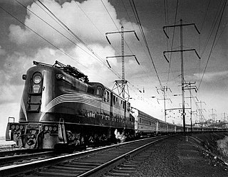
The Pennsylvania Railroad GG1 is a class of streamlined electric locomotives built for the Pennsylvania Railroad (PRR), in the northeastern United States. The class was known for its striking art deco shell, its ability to pull trains at up to 100 mph, and its long operating career of almost 50 years.

The E7 was a 2,000-horsepower (1,500 kW), A1A-A1A passenger train locomotive built by General Motors' Electro-Motive Division of La Grange, Illinois. 428 cab versions, or E7As, were built from February 1945 to April 1949; 82 booster E7Bs were built from March 1945 to July 1948. The 2,000 hp came from two 12 cylinder model 567A engines. Each engine drove its own electrical generator to power the two traction motors on one truck. The E7 was the eighth model in a line of passenger diesels of similar design known as EMD E-units, and it became the best selling E model upon its introduction.

A horseshoe curve is a class of climbing curve in a roadbed that reverses turn direction (inflection) twice on either side of a single tight curve that varies through an angle of about 180 degrees or more.

The Gallitzin Tunnels in Gallitzin, Pennsylvania, are a set of three adjacent tunnels through the Allegheny Mountains in western Pennsylvania. They were completed in 1854, 1855, and 1902 by the Pennsylvania Railroad as part of the cross-state route that includes the nearby Horseshoe Curve to the east. Their ownership has since passed to Penn Central Transportation Company, then to Conrail, and most recently to the Norfolk Southern Railway. The tunnels are currently used by Norfolk Southern freight trains and Amtrak Pennsylvanian passenger trains.

The Pennsylvania Railroad's class O1 comprised eight experimental boxcab electric locomotives built in 1930 and 1931. They were built in preparation for the New York to Washington Electrification project. They had the wheel arrangement classified as 4-4-4 in the Whyte notation. Although successful, they were not powerful enough for the railroad's increasingly heavy trains. For production, the PRR chose to concentrate on the P5 class, effectively an enlarged and more powerful version of the O1 with an additional pair of driving wheels.

Pavonia Yard is a Conrail Shared Assets Operations (CSAO) rail yard in Camden, New Jersey.

The East River Tunnels are four single-track railroad passenger service tunnels that extend from the eastern end of Pennsylvania Station under 32nd and 33rd Streets in Manhattan and cross the East River to Long Island City in Queens. The tracks carry Long Island Rail Road (LIRR) and Amtrak trains travelling to and from Penn Station and points to the north and east. The tracks also carry New Jersey Transit trains deadheading to Sunnyside Yard. They are part of Amtrak's Northeast Corridor, used by trains traveling between New York City and New England via the Hell Gate Bridge.
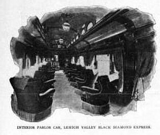
The Black Diamond, also known as the Black Diamond Express, was the flagship passenger train of the Lehigh Valley Railroad (LV). It ran from New York to Buffalo from 1896 until May 11, 1959, when the Lehigh Valley's passenger service was reduced to four mainline trains.

The Baltimore Belt Line was constructed by the Baltimore and Ohio Railroad (B&O) in the early 1890s to connect the railroad's newly constructed line to Philadelphia and New York City/Jersey City with the rest of the railroad at Baltimore, Maryland. It included the Howard Street Tunnel, the Mount Royal Station for B&O's Royal Blue Line passenger trains, and the first mainline railroad electrification in the United States. CSX Transportation currently operates the line as part of its Baltimore Terminal Subdivision.

The Main Line of the Pennsylvania Railroad was a rail line in Pennsylvania connecting Philadelphia with Pittsburgh via Harrisburg. The rail line was split into two rail lines, and now all of its right-of-way is a cross-state corridor, composed of Amtrak's Philadelphia to Harrisburg Main Line and the Norfolk Southern Railway's Pittsburgh Line.
Enola Yard is a large rail yard located in East Pennsboro Township, Pennsylvania, along the western shore of the Susquehanna River in Harrisburg, Pennsylvania.
Pennsylvania Railroad 1361 is a 4-6-2 K4 "Pacific" type steam locomotive built in May 1918 by the Pennsylvania Railroad's (PRR) Juniata Shops in Altoona, Pennsylvania. It hauled mainline passenger trains in Pennsylvania and commuter trains in Central New Jersey on the PRR until its retirement from revenue service in 1956. Restored to operating condition for excursion service in 1987, No. 1361 and its only surviving sister locomotive, No. 3750, were designated as the official state steam locomotives by the Pennsylvania General Assembly. In late 1988, it was sidelined due to mechanical problems and was currently owned by the Railroaders Memorial Museum (RMM) in Altoona, Pennsylvania, who were currently getting No. 1361 back to operation.
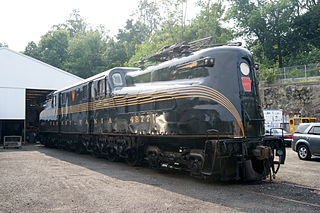
PRR 4877, formerly nicknamed "Big Red", is a GG1-class electric locomotive owned by the United Railroad Historical Society of New Jersey. It is stored at the West Boonton Yard in Boonton, New Jersey, United States. It is fully cosmetically restored to its original appearance.

Pennsylvania Railroad, Connecting Railway Bridge is a stone arch bridge in Philadelphia, Pennsylvania, that carries Amtrak Northeast Corridor rail lines and SEPTA and NJT commuter rail lines over the Schuylkill River. It is located in Fairmount Park, just upstream from the Girard Avenue Bridge.

The Wabash Railroad was a Class I railroad that operated in the mid-central United States. It served a large area, including track in the states of Ohio, Indiana, Illinois, Iowa, Michigan, and Missouri and the province of Ontario. Its primary connections included Chicago, Illinois; Kansas City, Missouri; Detroit, Michigan; Buffalo, New York; St. Louis, Missouri; and Toledo, Ohio.
The New York, Philadelphia and Norfolk Railroad was a railroad that owned and operated a line that ran down the spine of the Delmarva Peninsula from Delmar, Maryland to Cape Charles, Virginia and then by ferry to Norfolk, Virginia. It became part of the Pennsylvania Railroad system.
The New Portage Branch was a rail line which ran between the New Portage Tunnel and Duncansville, Pennsylvania.
