The Arctic Archipelago, also known as the Canadian Arctic Archipelago, is an archipelago lying to the north of the Canadian continental mainland, excluding Greenland and Iceland.

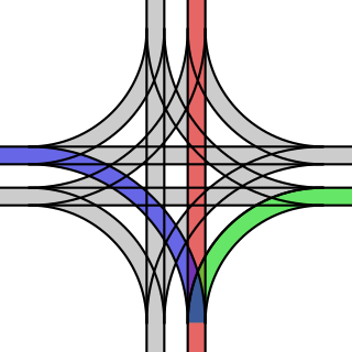
A grand union is a rail track junction where two double-track railway or tramway lines cross at grade, often in a street intersection or crossroads. A total of sixteen railroad switches allow streetcars coming from any direction to take any of the three other directions. The same effect may be achieved with two adjacent wyes if the location allows for space.

Québec is a federal electoral district that has been represented in the House of Commons of Canada since 1968. It is located in Quebec City in the province of Quebec, Canada.

Villatuelda is a Spanish village and municipality in the province of Burgos, part of the autonomous community of Castile and León. It has a population of approximately 60 people and it is 30 km from Aranda de Duero.

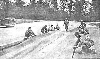
Advanced landing grounds (ALGs) were temporary advance airfields constructed by the Allies during World War II during the liberation of Europe. They were built in the UK prior to the invasion and thereafter in northwest Europe from 6 June 1944 to V-E Day, 7 May 1945.
Gorjani is a village located in the Užice municipality of Serbia. In the 2002 census, the village had a population of 735.

Maungdaw is a town in Rakhine State, in the western part of Myanmar (Burma). It is the administrative seat of Maungdaw Township and Maungdaw District. Bordering Bangladesh, Maungdaw is home to one of 2 official border trade posts with Bangladesh.
Nazarethpettai is a village approximately 10 kilometers north of Chennai. It is the birthplace of the former Chief Minister of Madras Presidency and leader of the Indian National Congress Minjur Bhaktavatsalam.
Hoghmik is a village in the Amasia Municipality of the Shirak Province of Armenia.
The following radio stations broadcast on AM frequency 1220 kHz: 1220 AM is a Mexican clear-channel frequency. XEB Mexico City is the dominant Class A station on 1220 kHz.
Sunfish Creek State Forest is a state forest in Monroe County, Ohio, United States.
Guerou is a city and department in south-central Mauritania. Guerou is the region's largest city after Kiffa, capital of Assaba Region. It is located at around 16°49′N11°50′W.
Dakoussa is a village and rural commune in the Takeita Department of the Zinder Region of Niger. As of 2012, it had a population of 61,779.

Korbous is a town and commune in the Nabeul Governorate, Tunisia. As of 2004 it had a population of 3,551.

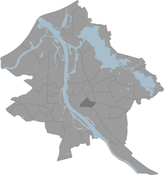
Avoti is a neighbourhood of Riga, the capital of Latvia. It is named after Avotu iela which runs horizontally through the middle of the area.
Kosco Glacier is a glacier about 20 nautical miles long, flowing from the Anderson Heights vicinity of the Bush Mountains of Antarctica northward to enter the Ross Ice Shelf between Wilson Portal and Mount Speed.
Fendorf Glacier is a broad glacier draining from the eastern slopes of the Gifford Peaks and flowing north to merge with Dobbratz Glacier, in the Heritage Range of the Ellsworth Mountains, Antarctica. It was mapped by the United States Geological Survey from ground surveys and U.S. Navy air photos, 1961–66, and was named by the Advisory Committee on Antarctic Names for Lieutenant Commander James E. Fendorf, U.S. Navy, a pilot with Squadron VX-6 during Operation Deep Freeze 1966.

Bander Beila, also known as Bander Beyla is a district in the northeastern Bari region of Puntland It is an old town near the Indian Ocean and is mountainous with old buildings. The Beyla region is a hybrid of fishing and a small number have farms. It is a peaceful region with little police
Royal Canadian Air Force Detachment Alliston was opened in July 1940 near the village of Alliston, Ontario. This small aerodrome served as the No. 2 Relief Landing Field for No. 1 Service Flying Training School of the British Commonwealth Air Training Plan, located at RCAF Station Camp Borden. The airfield at RCAF Detachment Alliston consisted of three runways in a standard triangular pattern, but unlike the RCAF Detachment Edenvale, they were compressed grass runways and there were no lights for night landings. The airfield was abandoned at the end of World War II and the land was sold for farmland.

The County of Newcastle is a county in the Wide Bay–Burnett region of Queensland, Australia. On 7 March 1901, the Governor issued a proclamation legally dividing Queensland into counties under the Land Act 1897. Its schedule described Newcastle thus:
Bounded on the east by the counties of Mackenzie and Boondooma; on the south by the Main Dividing Range; on the west by the eastern watershed of the Dawson River; on the north by the northern boundaries of the leased parts of Auburn and Hawkwood Runs and the Auburn River from the confluence of Narayen Creek downwards to its junction with the Burnett River.


