
Collect Pond, or Fresh Water Pond, was a body of fresh water in what is now Chinatown in Lower Manhattan, New York City. For the first two centuries of European settlement in Manhattan, it was the main New York City water supply system for the growing city. A jail was later built on the former pond. In the 20th century, the site became Collect Pond Park, which includes a reflecting pool to acknowledge the historic importance of this body of water.
Walden Pond is a celebrated pond in Concord, Massachusetts, in the United States. A good example of a kettle hole, it was formed by retreating glaciers 10,000–12,000 years ago. The pond is protected as part of Walden Pond State Reservation, a 335-acre (136 ha) state park and recreation site managed by the Massachusetts Department of Conservation and Recreation. The reservation was designated a National Historic Landmark in 1962 for its association with the writer Henry David Thoreau (1817–1862), whose two years living in a cabin on its shore provided the foundation for his famous 1854 work, Walden; or, Life in the Woods. The National Historic Preservation Act of 1966 ensured federal support for the preservation of the pond.
The Chevron Championship is a professional women's golf tournament. An event on the LPGA Tour, it is one of the tour's five major championships, and has traditionally been the first of the season since its elevation to major status in 1983. Since 2023, it has been played on the Jack Nicklaus Signature Course at The Club at Carlton Woods in The Woodlands, Texas.

Dug Pond is a small body of water in Natick, Massachusetts. Most notably it is home to Memorial Beach, one of few swimming beaches in Natick, and its eastern shore is the site of Natick High School.

Browning Pond is located in Oakham and Spencer, Massachusetts. This 89-acre (360,000 m2) great pond forms the headwaters of the Seven Mile River. It is part of the Chicopee River Watershed.
Fresh Pond is a 62-acre (250,000 m2) pond in the Manomet section of Plymouth, Massachusetts. The average depth is 12 feet (3.7 m) and the maximum depth is 30 feet (9.1 m). The southern shore of the pond is located in the Churchill Landing neighborhood, south of Manomet's business district and Manomet Bluffs, west of Fisherman's Landing, north of Cedar Bushes and Shallow Pond, and east of Beaver Dam Pond. Route 3A runs along the southeastern shore of the pond to its most southeastern point where it shoots away at a sharp curve known as the Brown Bear Curve, named after a defunct motel along the shore at that curve. A public beach, boat ramp, and a Native American burial site are located on the western shore of the pond on Bartlett Road, which has two intersections with Route 3A. The closer intersection is south of the Brown Bear Curve, while the other intersection is one mile (1.6 km) north, north of Manomet's business district. The pond is hydrologically associated with a cranberry bog operation located to the west of the pond. An unnamed brook heads west through the cranberry bog and ultimately leading to Beaver Dam Brook is the outflow of the pond.
Bartlett Pond is a 33-acre (130,000 m2) pond in the Manomet section of Plymouth, Massachusetts. The inflow of the pond is Beaver Dam Brook, and the outflow is a river that empties into Cape Cod Bay. White Horse Beach nearly surrounds the pond, lying to the southwest, west and north. Manomet Heights lies on the eastern shore.

Maquan Pond is a 48-acre (190,000 m2) pond in Hanson, Massachusetts. Its average depth is 12 feet (3.7 m) and its maximum depth is 18 feet (5.5 m). The pond is spring fed with an overflow on the south end that feeds into Indian Head Pond. There has been much development along the shore. The town has a right-of-way on the northern shore of the pond off Maquan Street. The town beach Cranberry Cove is at south end of the pond. The water is acidic, so fishing is poor except for pickerel, small yellow perch and pumpkinseeds.

Oldham Pond is a 232-acre (0.94 km2) pond in Pembroke and Hanson, Massachusetts. The pond is a tributary to Furnace Pond. There are three islands located in the middle of the pond, the largest of which is named Monument Island. On the Pembroke side of the pond, Oldham Village lies along the eastern shore, and Oldham Pines lies along the northeastern shore. Camp Pembroke, an all-girls Jewish summer camp, is located on this pond. The first camp out of Troop 1 Hanover, one of the oldest troops in Massachusetts, was held here in 1912.
Silver Lake is a 640-acre (2.6 km2) lake in Pembroke, Kingston, and Plympton, Massachusetts, south of Route 27 and east of Route 36. The Pembroke/Plympton town line is entirely within the lake, and a portion of the western shoreline of the lake is the town line with Halifax. It used to be called the Jones River Pond, but its name was changed to Silver Lake in the 1800s in a marketing effort to sell more ice from it. The lake is the principal water supply for the City of Brockton, whose water treatment plant is on Route 36 in Halifax. The inflow of the pond is Tubbs Meadow Brook, and the pond is the headwaters of the Jones River. Occasionally water is diverted into Silver Lake from Monponsett Pond in Halifax and Furnace Pond in Pembroke whenever there is a water shortage. Although the lake is a reservoir, which prevents recreational activities to keep the drinking water clean, the water from the diversions are not and can pump in contaminated water. Monponsett Pond in particular has reoccurring toxic algae growths which get transferred into the lake. It is supposed to be the main source of the Jones River by contributing about twenty percent of the river's flow, but the Forge Pond Dam near its base lets out minimal, some years no, water to the river. This also prevents migratory aquatic animals from reaching the lake. Brockton prefers to keep the dam to have more accessible water. Access to the pond is through Silver Lake Sanctuary, a 92-acre (370,000 m2) property where one can walk, hike and fish, which is located at the end of Barses Lane, off Route 27 in Kingston.

Wampatuck Pond is a 64-acre (260,000 m2) pond in Hanson, Massachusetts. Indian Head Brook both flows in and out of the pond. Along the northern shore of the pond are the Routes 14 and 58 concurrency, Hanson's Town Hall, and a small park. Kings Landing way is adjacent from fern hill cemetery opposite the pond. Native American burial site sits next to a man made pond on 34 and 54 kings landing way plots. Cranberry bogs on Main Street abut the town forest and southern side river ways to the pond.Access to the pond includes a concrete ramp behind the Hanson town hall managed by the Town of Hanson suitable for three trailers and six cars. The water quality is toxic and impaired due to noxious aquatic plants.

Hedges Pond is a 26-acre (110,000 m2) pond in the Cedarville section of Plymouth, Massachusetts with access from Hedges Pond Rd. The pond is located more than one mile (1.6 km) north of Cedarville's business district past the Route 3 underpass, southeast of Black Jimmy Pond, and east of Little Herring Pond. Hedges Pond has no private residences on its shores.
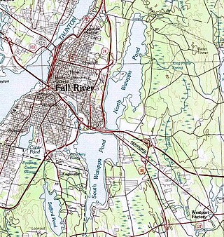
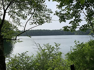
The Watuppa Ponds are two large, naturally occurring, spring-fed, glacially formed ponds located in Fall River and Westport, Massachusetts. Watuppa is a native word meaning "place of boats". The two ponds were originally one body of water, connected by a narrow rocky strait called "The Narrows" located on a thin strip of land between the two ponds which forms part boundary of between Fall River and Westport. The border between Fall River and Westport is also divided between the two ponds. Together, the ponds have an overall north–south length of about 7.5 miles, and have an average east–west width of about a mile. The ponds are drained by the Quequechan River, and flows in a westerly direction through the center of Fall River from South Watuppa Pond to Mount Hope Bay.

The Moose River is an 83-mile-long (134 km) river in Maine. Its source is in Beattie, on the Canada–United States border, which runs along the height of land between the watersheds of the Kennebec River in Maine and the Chaudière River in Quebec. From there, the river runs east through Attean Pond and Wood Pond, past the town of Moose River, then through Long Pond and Brassua Lake. The Moose River empties into Moosehead Lake, the source of the Kennebec River, in Rockwood Strip. The International Railway of Maine was built along Moose River in 1889.

The Sebec River is a tributary of the Piscataquis River in Piscataquis County, Maine. From the outflow of Sebec Lake in Sebec, the river runs 10.0 miles (16.1 km) east and southeast to its confluence with the Piscataquis in Milo.
The 2010 Fremantle Football Club season was the club's 16th season of competition in the Australian Football League (AFL). The club reached the finals for the third time and won its first ever Elimination Final, beating Hawthorn at Subiaco Oval before losing to Geelong at the MCG to end the season.
Chak No. 18 is a village located 70 kilometres (43 mi) from Lahore, the provincial capital of Punjab, Pakistan. Its another Real and old name is that of Rakh Mundy Ki Khurad. Chak18 is near the Changa Manga wildlife park. The economy is based on agriculture. It was settled in British India in 1906 on the bank of a canal.

The Palo Alto Baylands Nature Preserve, known officially as the Baylands Nature Preserve, is the largest tract of undisturbed marshland remaining in the San Francisco Bay. Fifteen miles of multi-use trails provide access to a unique mixture of tidal and fresh water habitats. The preserve encompasses 1,940 acres in both Palo Alto and East Palo Alto, and is owned by the city of Palo Alto, California, United States. It is an important habitat for migratory shorebirds and is considered one of the best birdwatching spots on the West Coast.

Enchanted Pond is a mountain pond in the U.S. state of Maine. Situated in the Western Maine Mountains in the Northwest Somerset Region, the pond is located in a deep mountain valley between Coburn Mountain and Shutdown Mountain. Near its southern end, the pond is distinguished by two rockslides from the exposed cliffs of these mountains that extend down into the water along both shores. Enchanted Pond is fed by mountain springs and Little Enchanted Pond, and is the primary source of Enchanted Stream which flows into the Dead River, a tributary of the Kennebec River. Development on the pond is limited to a small set of sporting camps at the northern end of the pond and one remote camp on the southwest shore, both a part of Bulldog Camps. There are no islands in the pond.
Menemsha Pond is a salt pond split between the towns of Aquinnah & Chilmark, Massachusetts. At the mouth of the pond, the Menemsha Creek leads into the Menemsha Bight and the Vineyard Sound. Along Menemsha Creek sits the historic sea-side fishing village of Menemsha. Menemsha Pond connects to both Stonewall Pond via Nashaquitsa Pond and to Squibnocket Pond via the Squibnocket Herring Run.
