
Ground transport in the Democratic Republic of the Congo (DRC) has always been difficult. The terrain and climate of the Congo Basin present serious barriers to road and rail construction, and the distances are enormous across this vast country. Furthermore, chronic economic mismanagement and internal conflict has led to serious under-investment over many years.

Katanga was one of the four large provinces created in the Belgian Congo in 1914. It was one of the eleven provinces of the Democratic Republic of the Congo between 1966 and 2015, when it was split into the Tanganyika, Haut-Lomami, Lualaba, and Haut-Katanga provinces. Between 1971 and 1997, its official name was Shaba Province.

Brazzaville is the capital and largest city of the Republic of the Congo. Administratively, it is a department and a commune. Constituting the financial and administrative centre of the country, it is located on the north side of the Congo River, opposite Kinshasa, the capital city of the Democratic Republic of the Congo.
Matadi is the chief sea port of the Democratic Republic of the Congo and the capital of the Kongo Central province, adjacent to the border with Angola. It had a population of 245,862 (2004). Matadi is situated on the left bank of the Congo River, 148 km (92 mi) from the mouth and 8 km (5.0 mi) below the last navigable point before the rapids that make the river impassable for a long stretch upriver.

The Democratic Republic of the Congo, also known as Congo-Kinshasa, Congo DR, DR Congo, DRC, or simply either Congo or the Congo, is a country in Central Africa. By land area, the DRC is the second-largest country in Africa and the 11th-largest in the world. With a population of around 105 million, the Democratic Republic of the Congo is the most populous Francophone country in the world, and the fourth-largest in Africa. The national capital and largest city is Kinshasa, which is also the economic center. The country is bordered by the Republic of the Congo, Central African Republic, South Sudan, Uganda, Rwanda, Burundi, Tanzania, Zambia, Angola, the Cabinda exclave of Angola, and the South Atlantic Ocean.

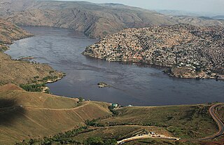
The Pool Malebo, formerly Stanley Pool, also known as Mpumbu, Lake Nkunda or Lake Nkuna by local indigenous people in pre-colonial times, is a lake-like widening in the lower reaches of the Congo River. The river serves as the border between the Republic of the Congo to the north and the Democratic Republic of the Congo to the south.
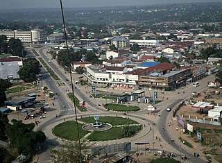
Kananga, formerly known as Luluabourg or Luluaburg, is the capital city of the Kasai-Central Province in the Democratic Republic of the Congo and was the capital of the former Kasaï-Occidental Province. It is the fourth most populous urban area in the country, with an estimated population of 1,524,000 in 2021.

Buta is a city in the northern Democratic Republic of the Congo, lying on the Rubi River, a tributary of the Itimbiri River. It is the capital of Bas-Uele province. As of 2012, it had an estimated population of 55,313.

The Congo–Ocean Railway links the Atlantic port of Pointe-Noire with Brazzaville, a distance of 502 kilometres (312 mi). It bypasses the rapids on the lower Congo River; from Brazzaville, river boats are able to ascend the Congo River and its major tributaries, including the Oubangui River to Bangui.
The Société Nationale des chemins de fer du Congo is the national railway company for the inland railways of the Democratic Republic of the Congo.

Comazar is a company that operates railways in Africa. Its stock is majority owned by the French investment group Bolloré. Comazar was founded by Eric Peiffer and Patrick Claes in conjunction with Transnet (Spoornet) and Transurb Consult in 1995.
Rail transport is provided in the Democratic Republic of the Congo by the Société Nationale des Chemins de Fer du Congo (SNCC), the Société commerciale des transports et des ports (SCTP) (previously Office National des Transports until 2011), and the Office des Chemins de fer des Ueles (CFU).

The Republic of the Congo was a sovereign state in Central Africa, created with the independence of the Belgian Congo in 1960. From 1960 to 1966, the country was also known as Congo-Léopoldville to distinguish it from its northwestern neighbor, which is also called the Republic of the Congo, alternatively known as "Congo-Brazzaville". In 1964, the state's official name was changed to the Democratic Republic of the Congo, but the two countries continued to be distinguished by their capitals; with the renaming of Léopoldville as Kinshasa in 1966, it became also known as Congo-Kinshasa. After Joseph Désiré Mobutu, commander-in-chief of the national army, seized control of the government in 1965, the Democratic Republic of the Congo became the Republic of Zaire in 1971. It would again become the Democratic Republic of the Congo in 1997. The period between 1960 and 1964 is referred to as the First Congolese Republic.
Wamba is a town in Haut-Uele province of the Democratic Republic of the Congo. It is the administrative center of Wamba territory.

Chemins de fer des Uele is a 600 mm narrow-gauge line in the north east of the Democratic Republic of the Congo. It was built between 1924 and 1937 as a portage railway bypassing Congo River rapids.
The Bima River is a river of Bas-Uélé province in the Democratic Republic of the Congo. It is a left tributary of the Uele River.
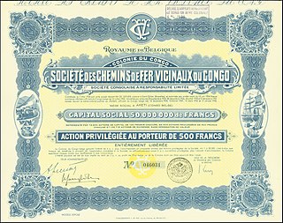
The Société des Chemins de Fer Vicinaux du Congo, known as CVC or Vicicongo, was a railway company that operated the narrow gauge Vicicongo line and provided trucking services in the northeast Belgian Congo, and then in the Democratic Republic of the Congo between 1924 and 1974. It provided transport for agricultural goods produced in the northeast that were shipped on the Congo River to Léopoldville (Kinshasa). After independence in 1960 there were civil disturbances and the railway was poorly maintained. The company was taken over by the state in 1974. Later there were further disturbances in which the stations were destroyed and the rolling stock used as a source of metal. The track is decrepit and no longer usable.
Andoma, formerly called Liénart, is a village in the Bas-Uélé province of the Democratic Republic of the Congo. It was a junction on the defunct Vicicongo line, a railway.
Mawa Gare is a village in the Bas-Uélé province of the Democratic Republic of the Congo. It was a station on the defunct Vicicongo line, a railway.
