Related Research Articles

Etawah also known as Ishtikapuri is a city on the banks of Yamuna River in the state of Western Uttar Pradesh in India. It is the administrative headquarters of Etawah District. Etawah's population of 256,838 makes it the one hundred and eightieth-most populous city in India. The city lies 300 km (190 mi) southeast of the national capital New Delhi, and 230 km (140 mi) northwest of the state capital Lucknow.

Firozabad district forms one of the western districts of the Indian state of Uttar Pradesh, which has Firozabad city as its district headquarters. The district is a part of the Agra division.
Bhind district is a district in the Chambal division of the Indian state of Madhya Pradesh. The town of Bhind is the district headquarters. Bhind District is situated in Chambal region in the northwest of the state. It is bounded by Agra, Etawah, Jalaun and Jhansi districts of Uttar Pradesh state to the north and the east, and the Madhya Pradesh districts of Datia to the south, Gwalior to the southwest, and Morena to the west. The geography of the district is characterised by uneven ravines, plain fertile fields and scanty forests. The total area of the district is 4,459 km2 (1,722 sq mi).
Achhalda is a town and a nagar panchayat in Auraiya district in the Indian state of Uttar Pradesh. It is also spelled as Achalda.
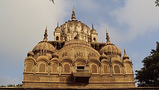
Auraiya is a city and a municipal board in Auraiya district in the state of Uttar Pradesh, India. NH 19 passes through the center of the town. Phaphund railway station is nearest Railway Station. Saifai Airstrip is the nearest aviation facility, having limited private use. Nearest commercial airport is the Kanpur Airport.Before becoming the district headquarters, it was the tehsil headquarters of Etawah district. This district is under Kanpur Mandal. [1] [2] [3] This is the heroic place of Sengar Rajputs. Sengar dynasty Kanardhani Maharajadhiraj Vishok Dev was married to Devkala, sister of Maharaja Jaichand Gaharwar (Rathore) of Kannauj. He had received this entire area in dowry. The famous Devkali temple here was also built by him in the name of his wife Devkali. There are many famous villages of Kshatriya in which Ayana, Bhartaul, Jaswantpur, Bhurepur Kalan, Bhurepur Khurd, Sikharna, Fareha, Anepur, Senganpur, Barbatpur, Roshangpur, Manpur, Phaphund, Aseva are very famous villages.
Bakewar is a town and a nagar panchayat in Etawah district in the state of Uttar Pradesh, India. It is 22 km from district headquarters Etawah. Bakewar is famous for its very good education system, Agriculture Training Institute and for National highway no. 2. Bakewar is situated at national highway no. 2. It is between Agra and Kanpur, the two biggest cities of Uttar Pradesh. Agra is 145 km north and Kanpur is 135 km on south of Bakewar. Bharthana is the nearest railway (11 km) of Bakewar, situated in the east.
Dibiyapur is a municipality-based city in Auraiya district in the most populous state of Uttar Pradesh in India. It is situated on State Highway 21. It is linked to Phaphund railway station on Kanpur–Delhi section of Howrah–Delhi main line and Howrah–Gaya–Delhi line which is operated by North Central Railway. The district administrative headquarter of the city is Auraiya. The city is situated between Agra and Kanpur and is famous for industries and education. Lower Ganga Canal passes through mid of the city.
Ekdil is a town and a nagar panchayat in Etawah district in the state of Uttar Pradesh, India. This place was established by the Ekdil Khan. It was earlier known as Sarai Rupa. In the 17th century, a eunuch named Ekdil Khan came here, and built a new sarai, which he named Ekdil. At the Time of Mahabharata, Present Day Ekdil was part of Ishtikapuri. It is 9 kilometers from Etawah). It has a small railway station on the north side, 3 kilometers town.It lies between Yamuna At its south around 10km and Ganga river at its North around 50km. It has majority population of 79% of Hindus and compromise approx 21% of Muslims.
Kora Jahanabad is a town in Fatehpur district and in Indian state of Uttar Pradesh. It is located on Kora Road, about 6 km east of Jahanabad, about 43 km south of Kanpur, 78 km west by northwest of Fatehpur, and 480 km southeast of Delhi. Local people also call it "Jahanabad".
Rajapur is a town and tehsil of Chitrakoot district in the Indian state of Uttar Pradesh. It is situated along the bank of river Yamuna. It has its nickname as "Tulsi Dhaam" after great Hindi poet Goswami Tulsidas, who is the writer of holy "Ram Charit Manas" along with many other religious books of Hindus. There is a temple devoted to Tulsidas where part of the original "Hand written Scripture" of Ramcharitmanas is still available, although some pages may be missing. Rajapur is linked with Kaushambi district on the opposite bank of river Yamuna.

Rasulabad is a town and a nagar panchayat in Kanpur Dehat district in the Indian state of Uttar Pradesh.
Rura is a Nagar Panchayat in Kanpur Dehat District in Uttar Pradesh state of the India. The town is situated on the banks of Lower Ganga canal. The district headquarters is 15 km away at Mati. The town is located at a distance of 49 km from famous industrial and educational hub of Kanpur Nagar.
Saurikh is a nagar panchayat in Kannauj district in the Indian state of Uttar Pradesh. Its old name was Sau-Rishi.It is located near main industrial and educational hub of Dibiyapur which is around at a distance of 55 km from the town.

Bateshwar is a village in Agra District, on the banks of the river Yamuna in the northern state of Uttar Pradesh, India. Bateshwar is in between Agra and Etawah and is 8 km from Bah. It is an important spiritual and cultural centre for Hindus and Jains. It is known for the 108 Shiv Temple Complex. An annual religious and animal fair is also organised in the village ground area.

Auraiya district is one of the districts of Uttar Pradesh state of India, and Auraiya town is the district headquarters. It lies on the south-western portion of Uttar Pradesh and also forms a part of the Kanpur Division.
Phaphund is a town and a nagar panchayat in Auraiya district in the Indian state of Uttar Pradesh.

Harchandpur is a village and corresponding community development block in Raebareli district, Uttar Pradesh, India. It is located on the Baiti river, which is a tributary of the Sai, and it is northeast from the district headquarters on the road to Lucknow. Particularly since the coming of the railway in the 1800s, Harchandpur serves as one of the main commercial centres for the surrounding region; it is also a major exporter of local goods. As of 2011, its population is 4,348 people, in 833 households.
The Pachnada is an area near Sindous (सिन्डौस) at the border of Jalaun district, Etawah district and Auraiya district of Uttar Pradesh state, India. It is also near the border of Bhind district of Madhya Pradesh state, where tourists can witness the confluence of five rivers, Kunwari, Pahuj, Yamuna, Chambal and Sind. This area is a rich habitat for dolphins.

Phaphund railway station is an "A" graded railway station in Auraiya district, Uttar Pradesh, India. Its code is PHD. It serves Auraiya district and Dibiyapur city. It is located on the Kanpur–Delhi section of Howrah–Delhi main line and Howrah–Gaya–Delhi line. It is one of the main serving railway stations on the Kanpur–Delhi section of the Allahabad railway division. Built during British rule, the station is owned by Indian Railways and operated by North Central Railway and consists of five tracks and four platforms.
Sahayal is a rural-based town in Auraiya district in the state of Uttar Pradesh, India.
References
- ↑ Election Commission of India (2002). "State Elections 2002" (Text/HTML). List of Contesting Candidates. Government of India . Retrieved 30 August 2010.
| | This Auraiya district location article is a stub. You can help Wikipedia by expanding it. |