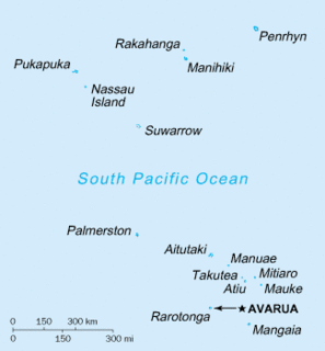
The Cook Islands can be divided into two groups: the Southern Cook Islands and the Northern Cook Islands. The country is located in Oceania, in the South Pacific Ocean, about one-half of the way from Hawaii to New Zealand.

An atoll, sometimes called a coral atoll, is a ring-shaped coral reef including a coral rim that encircles a lagoon partially or completely. There may be coral islands or cays on the rim. The coral of the atoll often sits atop the rim of an extinct seamount or volcano which has eroded or subsided partially beneath the water. The lagoon forms over the volcanic crater or caldera while the higher rim remains above water or at shallow depths that permit the coral to grow and form the reefs. For the atoll to persist, continued erosion or subsidence must be at a rate slow enough to permit reef growth upward and outward to replace the lost height.
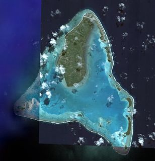
Aitutaki, also traditionally known as Araʻura and Utataki, is one of the Cook Islands, north of Rarotonga. It has a population of 1,712 in 2016. Aitutaki is the second most visited island of the Cook Islands. The main village is Arutanga (Arutunga) on the west side.

Pukapuka, formerly Danger Island, is a coral atoll in the northern group of the Cook Islands in the Pacific Ocean. It is one of most remote islands of the Cook Islands, situated about 1,140 kilometres northwest of Rarotonga. On this small island, an ancient culture and distinct language has been maintained over many centuries. The traditional name for the atoll is Te Ulu-o-Te-Watu, and the northern islet where the people normally reside is affectionately known as Wale ('Home'). The name Pukapuka is also ancient and referred originally to the people.

Manuae is an uninhabited atoll in the southern group of the Cook Islands, 100 kilometres south-east of Aitutaki. It is administratively part of Aitutaki, but it does not belong to any district or tapere of Aitutaki. It is, however, part of Arutanga-Reureu-Nikaupara Constituency.

Ee (island) is one of 22 islands in the Aitutaki atoll of the Cook Islands. Located between the smaller islands of Angarei and Mangere, it is the third largest of the Aitutaki motus, after Tekopua and Akaiami, and measures 975m long and up to 410m wide.
Tekopua is one of 22 islands in the Aitutaki atoll of the Cook Islands. It is located on the southeastern perimeter of Aitutaki Lagoon between the smaller islands of Muritapua and Tapuaetai, seven kilometres to the southeast of the main island of Aitutaki. It is the largest of the Aitutaki motu, measuring 2250m long and up to 480m wide.

Tapuaetai, or "One Foot Island", is one of 22 islands in the Aitutaki atoll of the Cook Islands. It is located on the southeastern perimeter of Aitutaki Lagoon immediately to the southwest of the larger island of Tekopua, seven kilometres to the east of the main island of Aitutaki. The island is 570m long and up to 210m wide, with an average elevation of 1.5m above sea level.
Motukitiu is one of 22 islands in the Aitutaki atoll of the Cook Islands. It is a small island located at the southeastern tip of Aitutaki Lagoon, one kilometre to the south of the larger island of Tekopua and eight kilometres to the southeast of the main island of Aitutaki. The island is 450m long and 300m wide.
Moturakau is one of 22 islands in the Aitutaki atoll of the Cook Islands. It is located in the southeast of Aitutaki Lagoon between the larger islands of Rapota and Tekopua, six kilometres to the southeast of the main island of Aitutaki. The island is 460m long and 120m wide. Moturakau served as a leper colony from the 1930s to 1967. More recently, it was home to the 'Sharks' for four years of the UK reality TV programme Shipwrecked: Battle of the Islands.
Rapota is one of 22 islands in the Aitutaki atoll of the Cook Islands. It is located in the south of Aitutaki Lagoon to the west of the smaller island of Moturakau, six kilometres to the southeast of the main island of Aitutaki. The island is volcanic, with a core of basalt surrounde dby basalt boulders.

Maina is one of 22 islands in the Aitutaki atoll of the Cook Islands. It is located at the southwestern extreme of Aitutaki Lagoon, five kilometres to the southwest of the main island of Aitutaki. The island is a sand cay 710m long and up to 310m wide. In front of Maina island stands a sandbar known as "Honeymoon Island" named after a Canadian couple who decided to get married here.
Akitua is one of 22 islands in the Aitutaki atoll of the Cook Islands. It is on the northeastern perimeter of Aitutaki Lagoon and is 750m long and up to 310m wide. The island is owned by the Aitutaki Lagoon Resort & Spa, a 5 star hotel equipped with luxury bungalows, restaurant and bar. It is known for its beautiful turquoise, indigo blue, beach.
Angarei is one of 22 islands in the Aitutaki atoll of the Cook Islands. It is located on the northeastern perimeter of Aitutaki Lagoon to the north of the larger island of Ee, three kilometres to the east of the main island of Aitutaki. The island is 480m long by 400m wide.
Mangere is one of 22 islands in the Aitutaki atoll of the Cook Islands. It is located on the northeastern perimeter of Aitutaki Lagoon to the south of the larger island of Ee, three kilometres to the east of the main island of Aitutaki. The island is 350m across.
Papau is one of 22 islands in the Aitutaki atoll of the Cook Islands. It is located on the eastern perimeter of Aitutaki Lagoon, four kilometres to the east of the main island of Aitutaki. The island is 400m long and 200m wide.
Tavaeruaiti is one of 22 islands in the Aitutaki atoll of the Cook Islands. It is located on the eastern perimeter of Aitutaki Lagoon to the north of the larger island of Tavaerua, four kilometres to the east of the main island of Aitutaki. The island is 250m long and 210m wide.
Tavaerua is one of 22 islands in the Aitutaki atoll of the Cook Islands. It is located on the eastern perimeter of Aitutaki Lagoon to the south of the smaller island of Tavaeruaiti, four kilometres to the east of the main island of Aitutaki. The island is 290m wide and 500m long and has an elevation of 7 metres (23 ft) above sea level.
Akaiami is one of 22 islands in the Aitutaki atoll of the Cook Islands. It is located on the eastern perimeter of Aitutaki Lagoon to the north of the smaller islands of Muritapua, five kilometres to the southeast of the main island of Aitutaki. It is the second-largest of the Aitutaki motus, after Tekopua, measuring 1120m long and 410m wide. During the 1950s the island was used as a stopover for TEAL flying boats on the famous Coral Route. These operations ceased in 1960, and the only reminder are the remains of the purpose-built jetty.
The Ootu Peninsula, though connected to the main island of Aitutaki atoll of the Cook Islands, may in many respects be considered as one of the reef islands, being the largest and longest of them. It is located at the northern end of the eastern perimeter of Aitutaki Lagoon to the north and then west of the northernmost true reef island, Akitua, from which is separated by a channel 50 metres wide and less than two metres deep. The southernmost point of the peninsula is called Aumoana. The northernmost point of the peninsula, Teaumera, is also the northernmost point of Aitutaki as a whole. In the northeast is Kopu a Ruatapu, a boat passage through the fringing coral reef.
