Related Research Articles

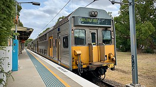
Waverton railway station is a heritage-listed railway station located on the North Shore line, serving the Sydney suburb of Waverton in New South Wales, Australia. It is served by Sydney Trains T1 North Shore line services. The station is located on Bay Road, Waverton, in the North Sydney Council local government area of New South Wales, Australia. It was designed and built by New South Wales Department of Railways. It is also known as Waverton Railway Station group. The station was added to the New South Wales State Heritage Register on 2 April 1999.

The Lapstone Zig Zag was a zig zag railway built between Emu Plains and Blaxland stations on the Main Western Line of New South Wales in Australia. Constructed between 1863 and 1865 to overcome an otherwise insurmountable climb up the eastern side of the Blue Mountains, the zig zag and associated Knapsack Viaduct, a sandstone arch viaduct, were designed by John Whitton, Engineer-in-Charge of New South Wales Government Railways, and were built by William Watkins. The zig zag was listed on the Blue Mountains local government heritage register on 27 December 1991; while the adjacent Knapsack Viaduct was listed on the New South Wales Heritage Database on 2 April 1999. The Lapstone Zig Zag was the world-first Zig Zag constructed on any main-line railway.

Albion Park railway station is a heritage-listed railway station located on the South Coast railway line on the Princes Highway in Albion Park Rail, New South Wales, Australia. The station was designed by New South Wales Government Railways and built during 1887 by William Monie & Company, with the single line railway line built by David Proudfoot and Thomas Logan. The complex is also known as the Albion Park Railway Station Group. The property was added to the New South Wales State Heritage Register on 2 April 1999. The station is located close to Shellharbour Airport.

Wollongong railway station is a heritage-listed railway station on the South Coast railway line in New South Wales, Australia. It serves the central business district of Wollongong. It was added to the New South Wales State Heritage Register on 2 April 1999.

Lake Bathurst is a shallow lake located 27 kilometres (17 mi) south-east of Goulburn, New South Wales in Australia. It is also the name of a nearby locality in the Goulburn Mulwaree Council.
Crowther station was located on the Blayney–Demondrille railway line, New South Wales, Australia.
Jerrawa was a small railway station, at the locality also known as Jerrawa, on the Main South railway line in New South Wales, Australia.
Argyle was a railway station on the Crookwell railway line, New South Wales, Australia. The station opened in 1902 with the opening of the line, and consisted of a 50 ft platform on the down side of the line. It gained its name from Argyle in Scotland, and was located adjacent to the Goulburn Training Centre.
Kenmore was a railway station on the Crookwell railway line, New South Wales, Australia. The station opened in 1902 with the opening of the line, and consisted of a 100 ft platform on the down side of the line. It gained its name from Kenmore a small village in Perthshire, Scotland, and was located adjacent to Kenmore Hospital. A 275 ft loop siding was constructed with the line, subsequently shortened in 1934 to 175 ft. In 1942, and additional siding was added. Passenger services ceased in 1974, and in 1975, the station and facilities closed and the platform was subsequently demolished. The line closed to goods traffic in 1984. The closed rail-line and loop remain in-situ.
The Norwood railway station was a railway station on the Crookwell railway line, New South Wales, Australia. The station opened in 1902 with the opening of the line, and consisted of a 30-metre (100 ft) platform on the down side of the line with a loop siding on the up side. The siding was removed in 1941 and the station closed in 1943 and was subsequently demolished. The line through Norwood closed to goods traffic in 1984.
The Forest was a railway station on the Crookwell railway line, New South Wales, Australia. The station opened in 1902 with the opening of the line, and consisted of a 100 ft platform on the down side of the line with a loop siding on the up side. It was named after an adjoining property named Forest Lodge. The platform was removed in 1969 and the loop closed in 1974 and was subsequently demolished. The line through The Forest closed to goods traffic in 1984.

Woodhouselee was a railway station on the Crookwell railway line, in Woodhouselee, New South Wales, Australia. The station opened in 1902 with the opening of the line, and consisted of a 100 ft platform on the up side of the line with a loop siding on the down side. It was named after a local resident Mr Woodhouse. The platform was closed in 1974 with the cessation of passenger services and subsequently demolished. The line through Woodhouselee closed to goods traffic in 1984, the loop has been removed but the mainline remains intact.

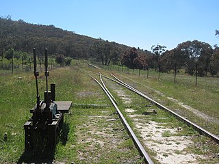
Roslyn was a railway station on the Crookwell railway line, New South Wales, Australia. The station opened in 1902 with the opening of the line, and consisted of a 100 ft platform on the down side of the line with a loop siding on the up side. Cattle loading facilities and goods sheds were also provided. It was named after the estate of a local resident Dr Mitchell. In 1925, the station became the location of the branch line to Taralga, with the new branch extending off the loop line.. The platform was shortened to 30 ft in 1969, and closed in 1974 with the cessation of passenger services. in 1975 the station and goods facilities were demolished. The line through Roslyn closed to goods traffic in 1984, and little remains at the site apart from the mainline track, the goods loading bank and the station master's residence.
McAlister was a railway station on the Crookwell railway line, New South Wales, Australia. The station opened in 1902 with the opening of the line, and consisted of a 100 ft platform on the up side of the line with a loop siding on the down side. It was named after magistrate Lachlan McAlister. Some goods facilities were removed in the 1930s. The remainder of the station and loop closed in 1969 and were subsequently removed. The line through McAlister closed to goods traffic in 1984. Little remains at the site apart from the mainline track and a loading bank.
Lilyvale railway station is a former railway station on the Illawarra railway line in New South Wales, Australia.
The Carlingford railway line was a railway line in Sydney, New South Wales, Australia. It was opened from Clyde to Subiaco in January 1885, then by means of the construction of a bridge across the Parramatta River, to Carlingford in April 1896. It closed on 5 January 2020 with much of the line to be converted to light rail as part of the Parramatta Light Rail network, while a short section of the line was retained for use by Sydney Trains.

Tirrannaville is a locality in the Goulburn Mulwaree Council, New South Wales, Australia. It is located about 11 km south of Goulburn on the road to Braidwood. It was formerly called Terranna, which is the name of the parish covering most of the locality. The northern part of the defined locality, including the small settlement of Tirrannaville and cemetery, is in the parish of Goulburn. At the 2016 census, it had a population of 237. The locality mostly consists of grazing land.
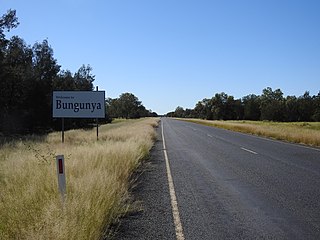
Bungunya is a rural town and locality in the Goondiwindi Region, Queensland, Australia. The locality is on the border of Queensland and New South Wales. In the 2016 census, Bungunya had a population of 75 people.
South Talwood is a rural locality in the Goondiwindi Region, Queensland, Australia. It is on the border of Queensland and New South Wales. In the 2016 census, South Talwood had a population of 95 people.
Tuggeranong is a former railway station, sometimes referred to as Tuggeranong Siding or Tuggeranong Platform, that was located on a now-disused portion of the Bombala railway line.
References
- ↑ Murrays Flats station. NSWrail.net. Accessed 19 August 2009.
- ↑ "Two Huge Depots For Bagged Wheat". The Land . No. 1491. New South Wales, Australia. 15 December 1939. p. 23. Retrieved 26 November 2016– via National Library of Australia.
34°43′22″S149°47′08″E / 34.722673°S 149.785688°E
| | This article about a railway station in New South Wales is a stub. You can help Wikipedia by expanding it. |