Related Research Articles

The Tumucumaque Mountains National Park is situated in the Amazon Rainforest in the Brazilian states of Amapá and Pará. It is bordered to the north by French Guiana and Suriname.

Amapá is one of the 26 states of Brazil. It is in the northern region of Brazil. It is the second least populous state and the eighteenth largest by area. Located in the far northern part of the country, Amapá is bordered clockwise by French Guiana to the north, the Atlantic Ocean to the east, Pará to the south and west, and Suriname to the northwest. The capital and largest city is Macapá. The state has 0.4% of the Brazilian population and is responsible for only 0.22% of the Brazilian GDP.

Macapá is a city in Brazil with a population of 512,902. It is the capital of Amapá state in the country's North Region. It is located on the northern channel of the Amazon River near its mouth on the Atlantic Ocean. The city is on a small plateau on the Amazon in the southeast of the state of Amapá. The only access by road from outside the province is from the overseas French department of French Guiana, although there are regular ferries to Belem, Brazil. Macapá is linked by road with some other cities in Amapá. The equator runs through the middle of the city, leading residents to refer to Macapá as "The capital of the middle of the world." It covers 6,407.12 square kilometres (2,473.80 sq mi) and is located northwest of the large inland island of Marajó and south of the border with French Guiana.
Oiapoque is a municipality in the north of the state of Amapá, Brazil. Its population is 27,906 and its area is 22,625 square kilometres (8,736 sq mi). Oiapoque is also a major river in the same state, forming the international border with French Guiana. The Oyapock River Bridge, connecting the village with Saint-Georges in French Guiana, was completed in 2011 but not opened to pedestrian or vehicle traffic until 2017.

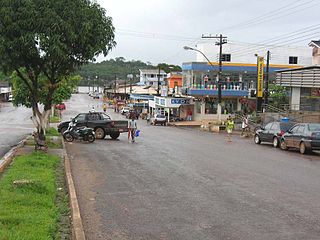
Amapá is a municipality located in the easternmost portion of the homonymous state of Amapá in Brazil. Its population is 9,187 and its area is 9,169 square kilometres (3,540 sq mi).

Cutias, formally known as Cutias do Araguari, is a municipality located in the southeast of the state of Amapá in Brazil. Its population is 6,101 and its area is 2,115 square kilometres (817 sq mi). The name of the municipality comes from a rodent of the same name, known in English as the agouti. Cutias do Araguari was elevated to the level of municipality on 1 May 1992.

Pedra Branca do Amapari, also known simply as Amapari, is a municipality located in the midwest of the state of Amapá in Brazil. Its population is 17,067 and its area is 9,495 square kilometres (3,666 sq mi). The municipality has a population density of 1.13/km2, and the population remains even divided between rural and village areas.

Santana is a municipality located in the southeast of the state of Amapá in Brazil. Its population is 123,096 and its area is 1,541 square kilometres, which makes it the smallest municipality of Amapá. Santana is a suburb of Macapá, the state capital, and the two cities make up the Metropolitan Area of Macapá. Its location is nearly on the equator. The planet's second longest river, the Amazon is to the south.
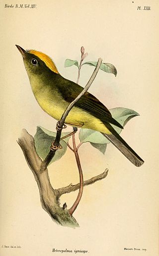
The saffron-crested tyrant-manakin, or saffron-crested neopelma, is a species of bird in the family Pipridae, the manakins.

The Palikur are an indigenous people located in the riverine areas of the Brazilian state of Amapá and in French Guiana, particularly in the south-eastern border region, on the north bank of the Oyapock River. The Palikur Nation, or naoné, is Arawak-speaking and socially organized in clans. In 2015, the estimated population was 2,300 people of which 1,400 lived in Brazil and 900 in French Guiana.
Karipuna or Caripuná may refer to:
Maracá-Jipioca Ecological Station is an ecological station covering two islands about 5 kilometres (3.1 mi) offshore from Amapá, a municipality in Amapá state, Brazil. It protects an area of coastal mangroves and tropical rainforest.

Jari Ecological Station is an ecological station in Brazil, located in the states of Amapá and Pará, created in 1984.

The Araguari River is the primary river of Amapá state in north-eastern Brazil. It became famous among surfers when some decided to ride its constant tidal bore, characterizing waves that can last for several minutes. In 2013, three dams were built in the river to generate hydroelectricity. The dams ended the tidal bore which altered the flow of water in the Amazon, and caused significant land erosion and damage to the Bailique Archipelago.

BR-156 is a federal highway of Brazil.

The Amapá National Forest is a national forest in the state of Amapá, Brazil. It supports sustainable exploitation of the natural resources in an area of Amazon rainforest in the Guiana Shield.
The Parazinho Biological Reserve is a biological reserve in the state of Amapá, Brazil. It protects an island at the mouth of the Amazon River.

The Karipuna do Amapá are an indigenous people located in the riverine areas of the Brazilian state of Amapá, particularly around the Caripi River. In 2014, the population was estimated at 2,922 people.

The Amapá Question, known in France as the Franco-Brazilian Dispute was a border dispute involving France and Brazil, in the end of the 19th century, culminating in the French intrusion in Amapá skirmishes in 1895.