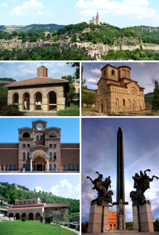
Veliko Tarnovo is a city in north central Bulgaria and the administrative centre of Veliko Tarnovo Province. It is the historical and cultural capital of Bulgaria.

Veliko Tarnovo is a province in the middle of the northern part of Bulgaria. Its capital city, Veliko Tarnovo, is of historical significance as it is known as the capital of the Bulgarian Empire. The province is divided into 10 municipalities with a total population, as of December 2009, of 275,395 inhabitants.
Pavlikeni is a town in Veliko Tarnovo Province, Northern Bulgaria, about 41 kilometers from the city of Veliko Tarnovo. It is the administrative centre of the homonymous Pavlikeni Municipality. As of December 2010, the town has a population of 11,604 inhabitants.
Byala Cherkva is a town in Pavlikeni Municipality, Veliko Turnovo Province, Central-North Bulgaria. The settlement is located close to the town of Pavlikeni about 28 km away from the city of Veliko Tarnovo. Its name in Bulgarian means white church, a popular placename around the world, equivalent to Bela Crkva, Weisskirchen, Whitechurch, etc. As of December 2009, the town has a population of 2,612 inhabitants.
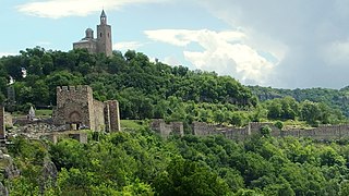
Tsarevets is a medieval stronghold located on a hill with the same name in Veliko Tarnovo in northern Bulgaria. Tsarevets is 206 metres (676 ft) above sea level. It served as the Second Bulgarian Empire's primary fortress and strongest bulwark between 1185 and 1393, housing the royal and the patriarchal palaces, and it is also a popular tourist attraction.
Gorna Oryahovitsa is a town in northern Bulgaria, situated in Veliko Tarnovo Province, 10 km (6 mi) from Veliko Tarnovo. It is the administrative centre of the homonymous Gorna Oryahovitsa Municipality. According to the 2021 Census, the town has a population of 27,317 inhabitants.

Dryanovo is a Bulgarian town situated at the northern foot of the Balkan Mountains in Gabrovo Province; amphitheatrically along the two banks of Dryanovo River, a tributary to the Yantra River. The town is a centre of the homonymous Dryanovo Municipality, which is composed of 62 villages, hamlets and huts picturesquely spread out of the mountain folds. As of 2015, it has a population of 7,968. In 2009, it was 8,043.

The stronghold of Cherven was one of the Second Bulgarian Empire's primary military, administrative, economic and cultural centres between the 12th and the 14th century. The ruins of the fortress are located near the village of the same name 30 to 35 kilometres south of Rousse, northeastern Bulgaria.

Lyaskovets is a town in central northern Bulgaria, located in homonymous municipality of Veliko Tarnovo Province, 10 km northeast of Veliko Tarnovo, 2 km southeast of Gorna Oryahovitsa and 5 km south of the Yantra River, north of the Balkan Mountains. Its name comes from the word leska ('hazel') or leshnik ('hazelnut'), because the tree was abundant in the area. As of December 2009, the town has a population of 10,314 inhabitants.

Kilifarevo is a small town in central northern Bulgaria, administratively part of Veliko Tarnovo Municipality, Veliko Tarnovo Province. Previously a village, it was proclaimed a town in 1973.
Bacho Kiro was the nickname of Kiro Petrov Zanev, a Bulgarian teacher, man of letters and revolutionary who took an active part in the April Uprising.

Veliko Tarnovo Municipality is a municipality (obshtina) in Veliko Tarnovo Province, Central-North Bulgaria, located mostly in the so-called Fore-Balkan area north of Stara planina mountain. It is named after its administrative centre - the old capital of the country, the city of Veliko Tarnovo which is also the main town of the province.

Elena Municipality is a municipality (obshtina) in Veliko Tarnovo Province, Central-North Bulgaria, located on the northern slopes of the central Stara planina mountain in the area of the so-called Fore-Balkan. It is named after its administrative centre, the town of Elena. It includes a territory of 671.39 km2 (259.23 sq mi) with a population of 10,407 inhabitants, as of December 2009.

Kovachevsko kale was a Roman city which lies 6 kilometres (4 mi) west of the Bulgarian town of Popovo. The Czech archaeologist Karel Škorpil called it Kovachoveshko kale, after the name of the nearby village, Kovachevets.
Vishovgrad is a village in the Veliko Tarnovo Province of northern Bulgaria.
Mihaltsi, or Mihalci, is a village in Pavlikeni Municipality, Veliko Tarnovo Province, northern Bulgaria. It is located at a distance of 9 km from the town of Pavlikeni, and 24 km from the city of Veliko Tarnovo.
Shemshevo is a village in northern Bulgaria, part of Veliko Tarnovo Municipality, Veliko Tarnovo Province. Shemshevo village is located on the left bank of the Yantra River about four kilometers west of the town of Veliko Tarnovo. Its land features diverse terrain with varying altitudes - from 130 m for the low lowlands to 210 meters in the southern part of the village. The population of the village is 579 people. The majority of the population is between 35 and 55 years old.
Prisovo is a village in the Veliko Tarnovo province of northern Bulgaria.

Ledenik is a village in Central North Bulgaria, in the Veliko Tarnovo Municipality, Veliko Tarnovo Province - near the municipal city of Veliko Tarnovo. South of the village passes the river Yantra. The name of the village comes from the fact that it was famous for its ice houses in the past.